- My Forums
- Tiger Rant
- LSU Score Board
- LSU Recruiting
- SEC Rant
- SEC Score Board
- Saints Talk
- Pelicans Talk
- More Sports Board
- Coaching Changes
- Fantasy Sports
- Golf Board
- Soccer Board
- O-T Lounge
- Tech Board
- Home/Garden Board
- Outdoor Board
- Health/Fitness Board
- Movie/TV Board
- Book Board
- Music Board
- Political Talk
- Money Talk
- Fark Board
- Gaming Board
- Travel Board
- Food/Drink Board
- Ticket Exchange
- TD Help Board
Customize My Forums- View All Forums
- Show Left Links
- Topic Sort Options
- Trending Topics
- Recent Topics
- Active Topics
Started By
Message
re: Tornado Outbreak: Survey Results: Page 49
Posted on 2/7/17 at 10:34 pm to rt3
Posted on 2/7/17 at 10:34 pm to rt3
I still can't figure out how the northshore tornado died literally minutes before wiping out Madisonville. One frame it look like it would be destroyed, the next frame circulation was gone
 1
1

Posted on 2/7/17 at 10:46 pm to tiggah1981
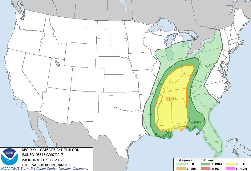
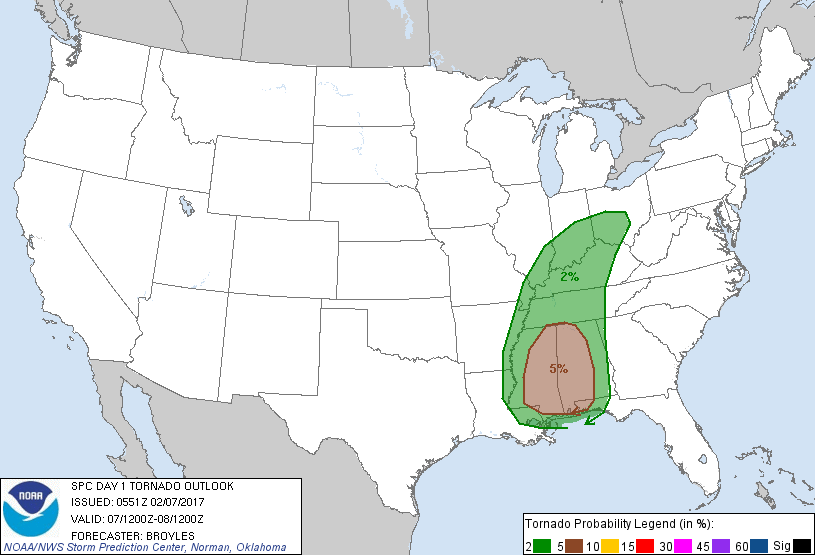
Today proves that the weather is hard. This was the last D2 outlook issued yesterday by SPC for today:

Then the D1 issued this morning:
Then the D1 updated issued mid morning:


The 00z NAM 4k certainly supported the low key outlooks going into today. It basically showed some decent parameters in place but had some capping and was not really firing off any storms:

With basically no signs of significant rotating updrafts (updraft helicity) that are typically associated with supercells that can produce tornadoes:

Then a pretty big shift on the 12z NAM 4k, it basically does away with any cap and fires off storms:

The model was now showing some updraft helicity but still nothing outrageous:

The morning surface analysis showed a "cold" front moving in from Texas and a subtle boundary draped across S. Louisiana with some minor wide shifts in the vicinity of New Orleans. The tornadoes appeared to have followed that boundary as they moved from west to east. There was nothing to scream, "tornado!" in the days leading up to today but SPC and local NWS offices did a great job of rapidly adjusting to the situation and getting watches and warnings out. As of now, it looks like no one was killed during the event. This will make for a great journal article for someone.
TL, DR


Then the D1 issued this morning:
Then the D1 updated issued mid morning:
The 00z NAM 4k certainly supported the low key outlooks going into today. It basically showed some decent parameters in place but had some capping and was not really firing off any storms:
With basically no signs of significant rotating updrafts (updraft helicity) that are typically associated with supercells that can produce tornadoes:
Then a pretty big shift on the 12z NAM 4k, it basically does away with any cap and fires off storms:
The model was now showing some updraft helicity but still nothing outrageous:
The morning surface analysis showed a "cold" front moving in from Texas and a subtle boundary draped across S. Louisiana with some minor wide shifts in the vicinity of New Orleans. The tornadoes appeared to have followed that boundary as they moved from west to east. There was nothing to scream, "tornado!" in the days leading up to today but SPC and local NWS offices did a great job of rapidly adjusting to the situation and getting watches and warnings out. As of now, it looks like no one was killed during the event. This will make for a great journal article for someone.
TL, DR
Posted on 2/7/17 at 11:03 pm to rds dc
you weather boys should collaborate with the climate scientists. there's a 99% concensus that their models are correct and they can project out over decades!
This post was edited on 2/7/17 at 11:06 pm
Posted on 2/8/17 at 5:41 am to TrebleHook
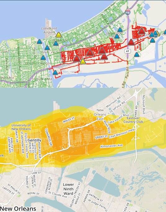
Has anyone seen a map with the damage path of the New Orleans East tornado.

Posted on 2/8/17 at 5:47 am to Roscoe
Predictive tornado track vs electricity outages.

Posted on 2/8/17 at 6:13 am to Roscoe
Posted on 2/8/17 at 7:30 am to CypressTrout10
quote:
I still can't figure out how the northshore tornado died literally minutes before wiping out Madisonville. One frame it look like it would be destroyed, the next frame circulation was gone
Complicated systems. It needs the atmosphere to have different wind speeds and different directions as you go up. It also needs a good feed of warm moist air to support the updraft.
What probably happened is the circulation started to catch the cooled air from the NOLA storms. Which limited the strength of the updraft as it rolled into the Northshore.
Posted on 2/8/17 at 7:55 am to Duke
Pretty good thought. Didnt think about other storms affecting it. Because if I remember correctly shortly after a NOLA storm and the Northshore storm combined

Posted on 2/8/17 at 8:21 am to TrebleHook
Shut the frick up
Posted on 2/8/17 at 8:24 am to rds dc
I'm taking mesoscale right now and I'm hoping to bring this up in class tomorrow. We've been talking about capping and all that good jazz so I feel like it fits in perfectly with everything.
Posted on 2/8/17 at 9:10 am to 1ranter1
hol-e-shite

Posted on 2/8/17 at 9:20 am to rds dc
quote:
TL;DR
pretty much what Carl Arredondo (WWL-TV Chief Meteorologist) said as I was watching their coverage... the atmospheric conditions changed so fast and became condusive for tornado development
Posted on 2/8/17 at 10:19 am to Pedro
quote:
I'm taking mesoscale right now and I'm hoping to bring this up in class tomorrow. We've been talking about capping and all that good jazz so I feel like it fits in perfectly with everything.
This event appears to have been driven by a dynamic mesoscale environment that was basically impossible to forecast ahead of time. I'll be interested to hear what comes out of your class discussions. I was traveling all day yesterday with limited internet access and noticed a few things looking at archived data last night.
This post was edited on 2/8/17 at 10:20 am
Posted on 2/8/17 at 10:37 am to rds dc
NWS has confirmed the NOLA tornado was an EF-3

Posted on 2/8/17 at 10:38 am to GEAUXmedic
Anyone know what the main streets that got fricked up in NOEast?
My buddy lives off of Crowder close the the dwyer canal between Chef hwy and I10
My buddy lives off of Crowder close the the dwyer canal between Chef hwy and I10

Posted on 2/8/17 at 10:44 am to SuperSaint
Mostly along Chef Hwy from what I can tell. From Mayo to the east.
This post was edited on 2/8/17 at 10:46 am

Posted on 2/8/17 at 10:47 am to MountainTiger
Thinking about you guys.
As someone who's lived through 3 major events like this since 1999, it's no bueno.
As someone who's lived through 3 major events like this since 1999, it's no bueno.
Posted on 2/8/17 at 11:07 am to GEAUXmedic
Holy shite, an F3. frick that.

 Page 48 of 49

Popular
Back to top