- My Forums
- Tiger Rant
- LSU Recruiting
- SEC Rant
- Saints Talk
- Pelicans Talk
- More Sports Board
- Fantasy Sports
- Golf Board
- Soccer Board
- O-T Lounge
- Tech Board
- Home/Garden Board
- Outdoor Board
- Health/Fitness Board
- Movie/TV Board
- Book Board
- Music Board
- Political Talk
- Money Talk
- Fark Board
- Gaming Board
- Travel Board
- Food/Drink Board
- Ticket Exchange
- TD Help Board
Customize My Forums- View All Forums
- Show Left Links
- Topic Sort Options
- Trending Topics
- Recent Topics
- Active Topics
Started By
Message
re: Tornado outbreak, 94 dead, Upwards of 100 unaccounted for search/rescue & cleanup ongoing
Posted on 12/10/21 at 9:45 am to deltaland
Posted on 12/10/21 at 9:45 am to deltaland
85% humidity. It’s 75 degrees out now so dewpoint now is 70 and will reach 77 at its peak. It will be 70-72 when storms get here
If this system were coming through mid afternoon it would be pretty bad
If this system were coming through mid afternoon it would be pretty bad
 1
1

Posted on 12/10/21 at 9:51 am to deltaland
here in CenLA... the streets are wet like it's recently rained... but I haven't seen a drop of rain since the last front came through earlier in the week
humid as a mofo
humid as a mofo

Posted on 12/10/21 at 10:27 am to rt3


Posted on 12/10/21 at 10:31 am to Briella
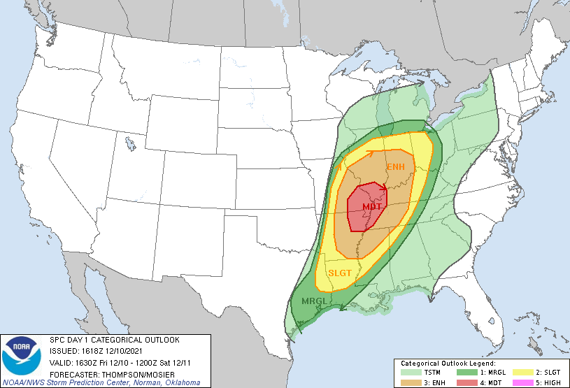
PSO issued
quote:
PUBLIC SEVERE WEATHER OUTLOOK NWS STORM PREDICTION CENTER NORMAN OK 1025 AM CST FRI DEC 10 2021 ...Severe thunderstorms expected over parts of the parts of the Mississippi and lower Ohio River Valleys this evening and overnight... * LOCATIONS... Eastern Missouri Eastern Arkansas Central and southern Illinois Western and middle Tennessee Western and central Kentucky Central and southern Indiana Northwestern Mississippi Extreme northwestern Alabama * HAZARDS... Several tornadoes, a few intense Scattered damaging winds Isolated large hail * SUMMARY... A few strong tornadoes, damaging gusts, and large hail are all expected beginning this evening across Arkansas and Missouri, with the greatest tornado threat close to the confluence of the Mississippi and Ohio Rivers. The damaging wind and tornado threat will persist overnight while spreading eastward into the Tennessee Valley and northeastward across the Ohio Valley overnight. Preparedness actions... Review your severe weather safety procedures for the possibility of dangerous weather today. Stay tuned to NOAA Weather Radio, weather.gov, or other media for watches and warnings. A tornado watch means that conditions are favorable for tornadoes to form during the next several hours. If a tornado warning is issued for your area, move to a place of safety, ideally in a basement or interior room on the lowest floor of a sturdy building.
Posted on 12/10/21 at 10:43 am to Briella
Moderate upgrade.
I can't read the discussion right now.
I can't read the discussion right now.
Posted on 12/10/21 at 10:47 am to LegendInMyMind
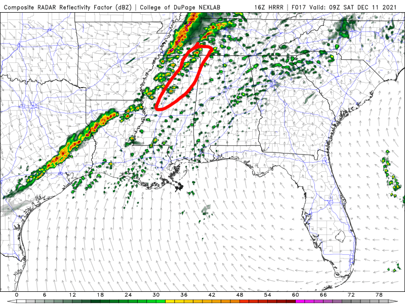
Still, for the Memphis area South into MS it is looking like multiple rounds of pre-frontal supercell storms. The 15z HRRR is the most concerning yet, in that regard.
This post was edited on 12/10/21 at 10:50 am
Posted on 12/10/21 at 10:51 am to LegendInMyMind
Question specifically for MS, west of I55: So we can expect isolate but severe storm cells. Any idea/projections of how widespread?
I understand isolated and widespread are contradictory but you know what I mean. I’m always on call when storms hit on the weekend. Looking at this from a power utility perspective.
I understand isolated and widespread are contradictory but you know what I mean. I’m always on call when storms hit on the weekend. Looking at this from a power utility perspective.

Posted on 12/10/21 at 10:53 am to LegendInMyMind
Don't see too many moderate risks in December.
Posted on 12/10/21 at 10:55 am to LegendInMyMind
Here is the discussion from SPC:
...THERE IS A MODERATE RISK OF SEVERE THUNDERSTORMS THIS EVENING
INTO TONIGHT FROM NORTHEAST AR/SOUTHEAST MO INTO WESTERN TN/KY AND
SOUTHERN IL...
...SUMMARY...
A few strong tornadoes, damaging gusts, and large hail are all
expected beginning this evening across Arkansas and Missouri, with
the greatest tornado threat close to the confluence of the
Mississippi and Ohio Rivers. The damaging wind and tornado threat
will persist overnight while spreading eastward into the Tennessee
Valley and northeastward across the Ohio Valley overnight.
...AR/MO this evening to TN/OH Valleys overnight...
A broad midlevel trough approaching the High Plains this morning
will continue eastward to the mid MS Valley overnight. The midlevel
trough is preceded by a remnant lee cyclone that will develop from
KS today to northern MO this evening, with more substantial
deepening overnight toward Lower MI. The surface warm sector will
spread northeastward from I-40 in eastern OK/AR to I-70 in MO/IL by
this evening, with additional expansion of the warm sector into
TN/KY/IN/OH through late tonight. Regional 12z soundings revealed
65-70 F boundary-layer dewpoints in the warm sector this morning,
beneath midlevel lapse rates close to 7.5 C/km. Surface heating in
cloud breaks and continued warm/moist advection through the day will
result in destabilization and weakening of convective inhibition in
the open warm sector and along the cold front by this evening, when
storm initiation is expected.
Deep-layer southwesterly winds will be strong with long hodographs
and some low-level, clockwise curvature in the warm sector
(effective bulk shear in excess of 70 kt and effective SRH in excess
of 300 m2/s2). MLCAPE of 1000-2000 J/kg, combined with the strong
vertical shear, will favor supercells capable of producing a few
strong tornadoes and large hail initially, with increasing storm
coverage and a greater threat for damaging winds overnight (in
addition to a continued tornado threat). A lead shortwave trough
now over the TX South Plains will likely provide the impetus for at
least widely scattered storm development in the open warm sector
from AR into MO by 21-00z, with storms expected increase in coverage
(both along and ahead of the cold front) and move rapidly
northeastward to the OH and TN Valleys overnight.
There is a 15% tornado probability in the moderate risk area:
This post was edited on 12/10/21 at 10:58 am
Posted on 12/10/21 at 10:55 am to MSUmtowndawg
Your area will likely see a good bit of activity with cells before the line forms. It looks like right now that the line will form either just to your West or right over you.
So, possibly multiple rounds for you tonight.
So, possibly multiple rounds for you tonight.

Posted on 12/10/21 at 11:24 am to LegendInMyMind
Is there a tornado probability outlook that includes Saturday for South LA? That current one stops at 12am correct? How bad we gonna get it?
Posted on 12/10/21 at 11:33 am to LegendInMyMind
Thanks. Glad to see the projections have moved north. Maybe we will just get some common variety thunderstorms
Posted on 12/10/21 at 11:36 am to rt3
quote:
Meteorologist Nick Mikulas
It’s a special kind of disgusting out there today. When it’s December, and it feels like this, typically something is about to happen. In this case, a severe weather event stretching from the Gulf Coast to Michigan is what’s on the table. The worst should stay to our north, but this summer meets winter airmass should bring a few severe storms to our area. Then tomorrow we put temperatures in reverse and will probably be 20 degrees colder at 4:00 PM than we were at midnight. Which is fine with me because I’ll be at a wedding, wearing a suit. Congratulations Weston and Janee’!
The details largely remain the same. Horrifying, rain forest humidity will continue through today. We will see 80 degrees across most of the area. This is the kind of air that makes my bald head have tiny little frizzy ends if you look really close. Tonight, after midnight, storms should form to our west, and push through between 2:00 and 10:00 AM. So a bit slower than originally anticipated. Rain should be less than an inch for most, and the main threat is isolated damaging wind, and perhaps a brief tornado. The better combination of severe weather ingredients will stay to our north, with cities like St. Louis and Indianapolis seeing a rare, December severe event. Sorry mom. I’d love to come up and storm chase. I mean come visit you for your birthday. Happy birthday you step getting champion of the north!
Behind this front, it’ll cool off quickly. There could be some lingering showers. Most models try and dry us out by noon, but a couple hang onto some scattered rain. I know I spoke with confidence that the afternoon parades would be dry tomorrow, but it does look like some scattered showers could linger. The severe threat will be long gone, but maybe an umbrella wouldn’t be the worst decision. A jacket will be required. I’m off to get some work done at the real job. I totally just snuck off to do this. But my boss is really cool. I’ll update this evening.
Posted on 12/10/21 at 11:38 am to trussthetruzz
quote:
Is there a tornado probability outlook that includes Saturday for South LA? That current one stops at 12am correct? How bad we gonna get it
It ends overnight, I think at 12z (6 am).
South Louisiana is too far south for the tornado dynamics. Not impossible to get a spin up but the threat is north into TN and MO, with a strong low cutting up that direction.
Posted on 12/10/21 at 12:13 pm to LegendInMyMind
quote:
multiple rounds for you tonight
That’s what she said?…

Posted on 12/10/21 at 12:17 pm to Duke
Surface low way too far north to be a big Louisiana event. We get hammered when the low rides up through central and east Texas.
Posted on 12/10/21 at 12:24 pm to MywifesAsst
That pre-frontal boundary isn't a good look for North MS. Then, you have a heavily segmented line behind it. I could see this type setup pushing the tornado threat farther East into the Enhanced and Slight areas of Alabama if those storms can stay discrete or the line doesn't fill in.
Posted on 12/10/21 at 12:32 pm to LegendInMyMind
I haven't followed any of this thread but just want to confirm that we are not having a White Christmas in New Orleans, correct?
Posted on 12/10/21 at 12:45 pm to MrLSU
quote:
I haven't followed any of this thread but just want to confirm that we are not having a White Christmas in New Orleans, correct?
Only if you're on the northshore.
Posted on 12/10/21 at 12:47 pm to Duke
New Orleans had a white Christmas in 2004. Can't ever rule it out 

 Page 5 of 90

Popular
Back to top