- My Forums
- Tiger Rant
- LSU Score Board
- LSU Recruiting
- SEC Rant
- SEC Score Board
- Saints Talk
- Pelicans Talk
- More Sports Board
- Coaching Changes
- Fantasy Sports
- Golf Board
- Soccer Board
- O-T Lounge
- Tech Board
- Home/Garden Board
- Outdoor Board
- Health/Fitness Board
- Movie/TV Board
- Book Board
- Music Board
- Political Talk
- Money Talk
- Fark Board
- Gaming Board
- Travel Board
- Food/Drink Board
- Ticket Exchange
- TD Help Board
Customize My Forums- View All Forums
- Show Left Links
- Topic Sort Options
- Trending Topics
- Recent Topics
- Active Topics
Started By
Message
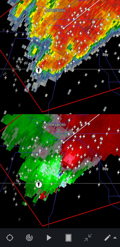
re: Tornado outbreak, 94 dead, Upwards of 100 unaccounted for search/rescue & cleanup ongoing
Posted on 12/10/21 at 7:01 pm to deltaland

Posted on 12/10/21 at 7:01 pm to deltaland
Severe Weather Statement
National Weather Service Memphis TN
656 PM CST Fri Dec 10 2021
ARC031-055-093-111-110130-
/O.CON.KMEG.TO.W.0060.000000T0000Z-211211T0130Z/
Greene AR-Craighead AR-Poinsett AR-Mississippi AR-
656 PM CST Fri Dec 10 2021
...A TORNADO WARNING REMAINS IN EFFECT UNTIL 730 PM CST FOR SOUTH
CENTRAL GREENE...CRAIGHEAD...NORTH CENTRAL POINSETT AND WESTERN
MISSISSIPPI COUNTIES...
At 655 PM CST, a confirmed large and extremely dangerous tornado was
located near Greenfield, or near Jonesboro, moving northeast at 60
mph.
This is a PARTICULARLY DANGEROUS SITUATION. TAKE COVER NOW!
HAZARD...Damaging tornado.
SOURCE...Weather spotters confirmed tornado.
IMPACT...You are in a life-threatening situation. Flying debris may
be deadly to those caught without shelter. Mobile homes
will be destroyed. Considerable damage to homes,
businesses, and vehicles is likely and complete destruction
is possible.
The tornado will be near...
Trumann and Bay around 705 PM CST.
Lake City and Brookland around 710 PM CST.
Monette and Caraway around 720 PM CST.
Other locations impacted by this tornadic thunderstorm include
Hergett, Apt, Vail, Valley View, Macey, Schug, Gum Point, Farrville,
Lester and Mandalay.
PRECAUTIONARY/PREPAREDNESS ACTIONS...
To repeat, a large, extremely dangerous and potentially deadly
tornado is on the ground. To protect your life, TAKE COVER NOW! Move
to a storm shelter or an interior room on the lowest floor of a
sturdy building. Avoid windows. If you are outdoors, in a mobile
home, or in a vehicle, move to the closest substantial shelter and
protect yourself from flying debris.
Tornadoes are extremely difficult to see and confirm at night. Do not
wait to see or hear the tornado. TAKE COVER NOW!
&&
LAT...LON 3561 9074 3580 9090 3609 9045 3575 9019
TIME...MOT...LOC 0055Z 244DEG 50KT 3573 9070
TORNADO...OBSERVED
TORNADO DAMAGE THREAT...CONSIDERABLE
MAX HAIL SIZE...1.00 IN
$$
 0
0

Posted on 12/10/21 at 7:02 pm to LegendInMyMind
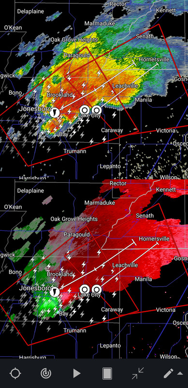
And the next scan is worse:
This post was edited on 12/10/21 at 7:05 pm
Posted on 12/10/21 at 7:04 pm to LegendInMyMind
There will be some decent video of this tornado. All the lightning will show it off.
This post was edited on 12/10/21 at 7:05 pm

Posted on 12/10/21 at 7:04 pm to LegendInMyMind

Posted on 12/10/21 at 7:06 pm to Bobby OG Johnson
quote:
SevereStudios
@severestudios
Confirmed tornado crossed Hwy 1 south of Jonesboro, AR about 5 min ago according to SS chaser @JordanHallWX

Posted on 12/10/21 at 7:06 pm to Bobby OG Johnson
Confirmed large and extremely dangerous tornado per NWS.
Posted on 12/10/21 at 7:06 pm to Bobby OG Johnson
They're going to end up warning that whole line.

Posted on 12/10/21 at 7:07 pm to Roll Tide Ravens
Just crossed 163
Posted on 12/10/21 at 7:07 pm to Bobby OG Johnson

Posted on 12/10/21 at 7:08 pm to Roll Tide Ravens
Meso strength of 6687 on that. Goodness.
Posted on 12/10/21 at 7:09 pm to pioneerbasketball
frick another warning south of Conway. My grandparents live between Beebe and Vilonia
Posted on 12/10/21 at 7:10 pm to LegendInMyMind
Just got alert for tornado warning in Central AR, northern Pulaski, southern Faulkner counties
Posted on 12/10/21 at 7:10 pm to deltaland
quote:
My grandparents live between Beebe and Vilonia
Tornado alley
Posted on 12/10/21 at 7:11 pm to LegendInMyMind
Situational awareness:


Sure as hell a potent environment right now, as evidence by *points at radar*
Sure as hell a potent environment right now, as evidence by *points at radar*
Posted on 12/10/21 at 7:11 pm to pioneerbasketball
I555
Posted on 12/10/21 at 7:12 pm to Bobby OG Johnson
quote:
Bobby OG Johnson
Could you post the text with those MCDs?
I am very lazy.
Posted on 12/10/21 at 7:13 pm to Duke
In regards to the Missouri storms:
You know wind is legit when you get similar readings on tilt one and tilt three. Jesus.
You know wind is legit when you get similar readings on tilt one and tilt three. Jesus.
Posted on 12/10/21 at 7:13 pm to Duke
Basketball game in bay
Posted on 12/10/21 at 7:13 pm to Bobby OG Johnson
quote:
damn... Moo St's Mike Leach has a town named after him in Arkansas?
SEC!
SEC!
SEC!
SEC!
This post was edited on 12/10/21 at 7:18 pm

 Page 13 of 90

Popular
Back to top