




 1
1











- My Forums
- Tiger Rant
- LSU Recruiting
- SEC Rant
- Saints Talk
- Pelicans Talk
- More Sports Board
- Fantasy Sports
- Golf Board
- Soccer Board
- O-T Lounge
- Tech Board
- Home/Garden Board
- Outdoor Board
- Health/Fitness Board
- Movie/TV Board
- Book Board
- Music Board
- Political Talk
- Money Talk
- Fark Board
- Gaming Board
- Travel Board
- Food/Drink Board
- Ticket Exchange
- TD Help Board
Customize My Forums- View All Forums
- Show Left Links
- Topic Sort Options
- Trending Topics
- Recent Topics
- Active Topics
Started By
Message
Posted on 4/26/26 at 8:01 pm to LegendInMyMind
Twin tornadoes near Foraker, OK.
Posted on 4/26/26 at 8:06 pm to Roll Tide Ravens
Here's some DOW radar porn from a storm a few days back:
Loading Twitter/X Embed...
If tweet fails to load, click here.Posted on 4/26/26 at 8:16 pm to LegendInMyMind
Looks like I'll have to stay up late tonight unfortunately.
The last tornado that came through my area in NWA was 2024. Storm was moving west to east if not SE.
These storms out in OK and KS are moving the same direction.
Most tornado warned storms fizzle out when they get towards NWA and they are typically moving SW to NE. I don't know if it's something topographic, or just strictly condition based. We have the occasional QLCS tornado, but rarely the super cell version like in 2024.
The last tornado that came through my area in NWA was 2024. Storm was moving west to east if not SE.
These storms out in OK and KS are moving the same direction.
Most tornado warned storms fizzle out when they get towards NWA and they are typically moving SW to NE. I don't know if it's something topographic, or just strictly condition based. We have the occasional QLCS tornado, but rarely the super cell version like in 2024.
Posted on 4/26/26 at 9:45 pm to rds dc
Confirmed tornado west of Joplin, MO.
Posted on 4/26/26 at 9:51 pm to Roll Tide Ravens
Looks like the same cell that dropped the independence one earlier
Posted on 4/26/26 at 9:53 pm to Pedro
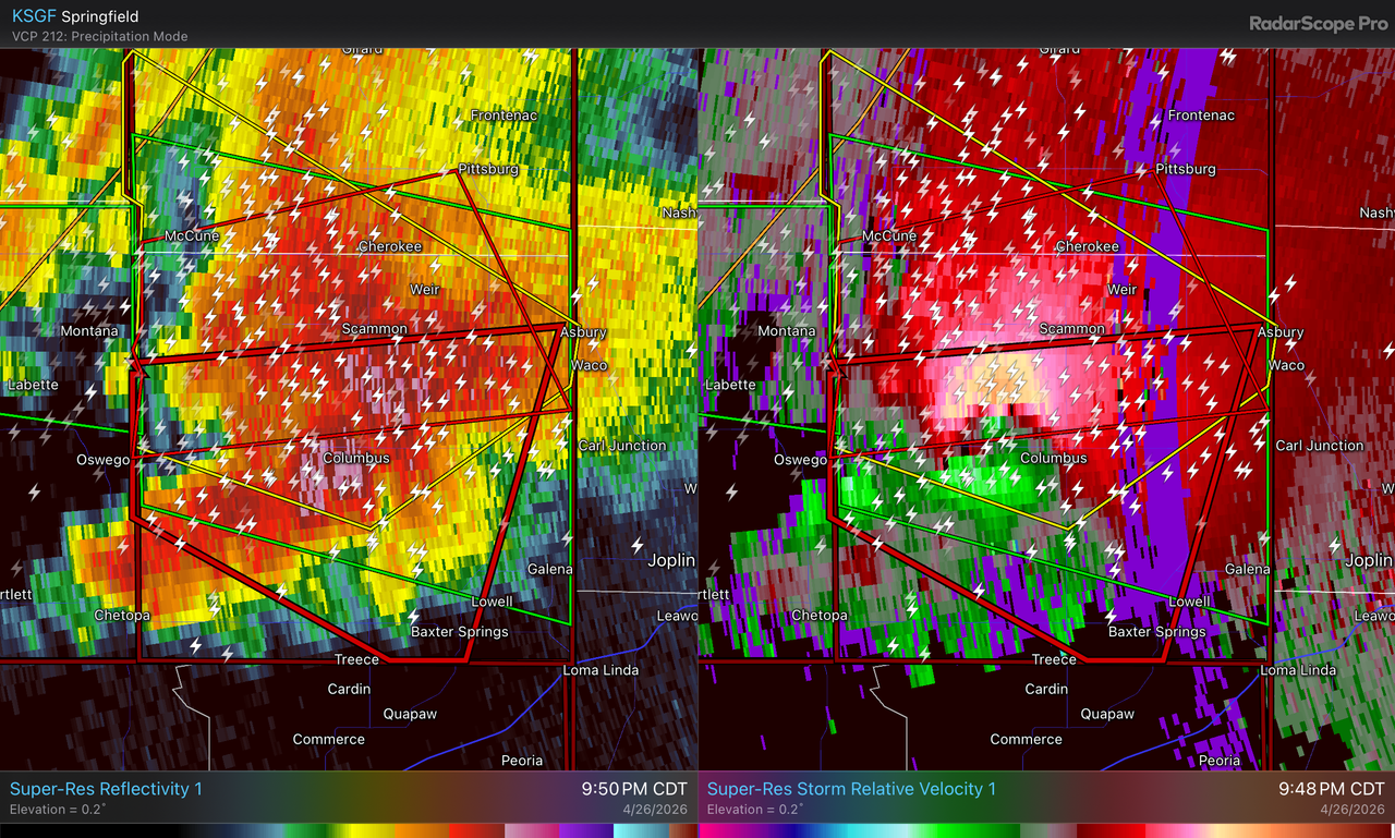
Severe Weather Statement
National Weather Service Springfield MO
951 PM CDT Sun Apr 26 2026
...A TORNADO WARNING REMAINS IN EFFECT UNTIL 1030 PM CDT FOR CENTRAL CHEROKEE COUNTY...
At 951 PM CDT, a confirmed large and extremely dangerous tornado was located near Columbus, moving east at 20 mph.
This is a PARTICULARLY DANGEROUS SITUATION. TAKE COVER NOW!
HAZARD...Damaging tornado.
SOURCE...Radar confirmed tornado.
IMPACT...You are in a life-threatening situation. Flying debris may be deadly to those caught without shelter. Mobile homes will be destroyed. Considerable damage to homes, businesses, and vehicles is likely and complete destruction is possible.
Locations impacted include... Baxter Springs, Columbus, Neutral, Skidmore, Hallowell, Sherwin, Riverton, Faulkner, Stippville, and Crestline.
Posted on 4/26/26 at 10:01 pm to Roll Tide Ravens
Sounds like a tornado is tracking towards Joplin? If true, that town is as big of a tornado magnet as any
Posted on 4/26/26 at 10:02 pm to Roll Tide Ravens
PDS tornado warning now includes Joplin, MO.
Tornado Warning
National Weather Service Springfield MO
1002 PM CDT Sun Apr 26 2026
The National Weather Service in Springfield has issued a
* Tornado Warning for... Eastern Cherokee County in southeastern Kansas... Northwestern Newton County in southwestern Missouri... Western Jasper County in southwestern Missouri...
* Until 1045 PM CDT.
* At 1001 PM CDT, a confirmed large and extremely dangerous tornado was located near Columbus, moving east at 40 mph.
This is a PARTICULARLY DANGEROUS SITUATION. TAKE COVER NOW!
HAZARD...Damaging tornado.
SOURCE...Weather spotters confirmed tornado.
IMPACT...You are in a life-threatening situation. Flying debris may be deadly to those caught without shelter. Mobile homes will be destroyed. Considerable damage to homes, businesses, and vehicles is likely and complete destruction is possible.
* Locations impacted include... Joplin, Carthage, Webb City, Carl Junction, Baxter Springs, Galena, Oronogo, Carterville, Duquesne, Duenweg, Jasper, Diamond, Airport Drive, Leawood, Lowell, Silver Creek, Alba, Purcell, Shoal Creek Drive, and Saginaw.
Tornado Warning
National Weather Service Springfield MO
1002 PM CDT Sun Apr 26 2026
The National Weather Service in Springfield has issued a
* Tornado Warning for... Eastern Cherokee County in southeastern Kansas... Northwestern Newton County in southwestern Missouri... Western Jasper County in southwestern Missouri...
* Until 1045 PM CDT.
* At 1001 PM CDT, a confirmed large and extremely dangerous tornado was located near Columbus, moving east at 40 mph.
This is a PARTICULARLY DANGEROUS SITUATION. TAKE COVER NOW!
HAZARD...Damaging tornado.
SOURCE...Weather spotters confirmed tornado.
IMPACT...You are in a life-threatening situation. Flying debris may be deadly to those caught without shelter. Mobile homes will be destroyed. Considerable damage to homes, businesses, and vehicles is likely and complete destruction is possible.
* Locations impacted include... Joplin, Carthage, Webb City, Carl Junction, Baxter Springs, Galena, Oronogo, Carterville, Duquesne, Duenweg, Jasper, Diamond, Airport Drive, Leawood, Lowell, Silver Creek, Alba, Purcell, Shoal Creek Drive, and Saginaw.
This post was edited on 4/26/26 at 10:04 pm
Posted on 4/26/26 at 10:03 pm to Roll Tide Ravens
Oh boy.. Joplin 
Hopefully it lifts.
NWA looks clear at this point.
Hopefully it lifts.
NWA looks clear at this point.
Posted on 4/26/26 at 10:06 pm to Roll Tide Ravens
Posted on 4/26/26 at 10:12 pm to Roll Tide Ravens
Posted on 4/26/26 at 10:16 pm to Roll Tide Ravens
Damn.
Posted on 4/26/26 at 10:16 pm to Roll Tide Ravens
frick I know so many people in that area…
Posted on 4/26/26 at 10:18 pm to Roll Tide Ravens
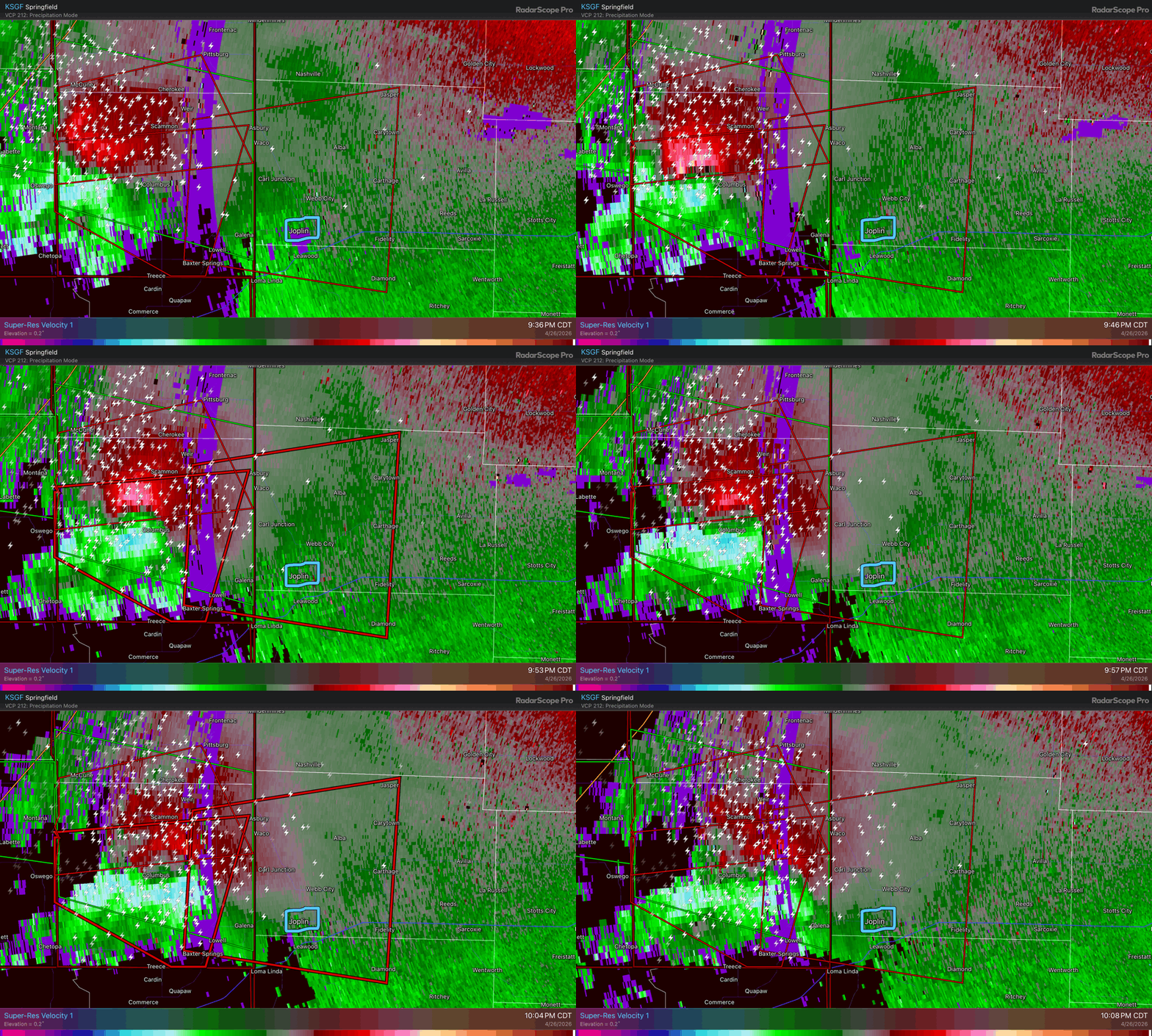
Hard to tell given the distance from the radar, but the rotation on the storm approaching Joplin doesn’t look as strong on velocity. Hopefully it’s not producing a tornado anymore.
Posted on 4/26/26 at 10:21 pm to Roll Tide Ravens
NWS has removed the PDS tag on the tornado warning for Joplin and they aren’t calling it a confirmed tornado in the text of the warning anymore.
Posted on 4/26/26 at 10:23 pm to Roll Tide Ravens
Well that’s good
Posted on 4/26/26 at 10:37 pm to Pedro
A new tornado watch was issued about an hour ago for much of western Oklahoma and southern Kansas, valid until 4:00 AM CDT.

URGENT - IMMEDIATE BROADCAST REQUESTED
Tornado Watch Number 155
NWS Storm Prediction Center Norman OK
940 PM CDT Sun Apr 26 2026
The NWS Storm Prediction Center has issued a
* Tornado Watch for portions of
Southern Kansas
Western and North Central Oklahoma
* Effective this Sunday night and Monday morning from 940 PM
until 400 AM CDT.
* Primary threats include...
A few tornadoes and a couple intense tornadoes possible
Scattered large hail and isolated very large hail events to 3
inches in diameter likely
Scattered damaging wind gusts to 70 mph likely
SUMMARY...Isolated supercell thunderstorms are expected tonight near
a warm front lifting northward into southern Kansas. These storms
will pose a risk for a few tornadoes (some may be strong), large to
very large hail, and damaging wind gusts. A more conditional risk
exists across western Oklahoma along a retreating dryline. If a
storm develops across this area, a very favorable environment will
support a risk for tornadoes, very large hail, and damaging wind
gusts.
URGENT - IMMEDIATE BROADCAST REQUESTED
Tornado Watch Number 155
NWS Storm Prediction Center Norman OK
940 PM CDT Sun Apr 26 2026
The NWS Storm Prediction Center has issued a
* Tornado Watch for portions of
Southern Kansas
Western and North Central Oklahoma
* Effective this Sunday night and Monday morning from 940 PM
until 400 AM CDT.
* Primary threats include...
A few tornadoes and a couple intense tornadoes possible
Scattered large hail and isolated very large hail events to 3
inches in diameter likely
Scattered damaging wind gusts to 70 mph likely
SUMMARY...Isolated supercell thunderstorms are expected tonight near
a warm front lifting northward into southern Kansas. These storms
will pose a risk for a few tornadoes (some may be strong), large to
very large hail, and damaging wind gusts. A more conditional risk
exists across western Oklahoma along a retreating dryline. If a
storm develops across this area, a very favorable environment will
support a risk for tornadoes, very large hail, and damaging wind
gusts.
This post was edited on 4/26/26 at 10:38 pm
Posted on 4/26/26 at 10:42 pm to Roll Tide Ravens
Glad to see that fall apart a bit heading into Joplin.
Posted on 4/26/26 at 10:47 pm to razorbackfan4life
quote:
The last tornado that came through my area in NWA was 2024. Storm was moving west to east if not SE.
Was that the Decatur tornado?

 Page 5 of 6


Popular

Back to top
 Follow TigerDroppings for LSU Football News