- My Forums
- Tiger Rant
- LSU Recruiting
- SEC Rant
- Saints Talk
- Pelicans Talk
- More Sports Board
- Fantasy Sports
- Golf Board
- Soccer Board
- O-T Lounge
- Tech Board
- Home/Garden Board
- Outdoor Board
- Health/Fitness Board
- Movie/TV Board
- Book Board
- Music Board
- Political Talk
- Money Talk
- Fark Board
- Gaming Board
- Travel Board
- Food/Drink Board
- Ticket Exchange
- TD Help Board
Customize My Forums- View All Forums
- Show Left Links
- Topic Sort Options
- Trending Topics
- Recent Topics
- Active Topics
Started By
Message
re: Tornado! Long-lived Tornadic Supercell Pushing into Western DFW
Posted on 4/26/26 at 10:50 pm to Roll Tide Ravens

Posted on 4/26/26 at 10:50 pm to Roll Tide Ravens
Well frick.
Usually these time out in the late afternoon for us. Don’t like having to worry about this going to bed with an infant that sleeps with a sound machine in our room
Usually these time out in the late afternoon for us. Don’t like having to worry about this going to bed with an infant that sleeps with a sound machine in our room
 0
0


Posted on 4/26/26 at 10:51 pm to Roll Tide Ravens
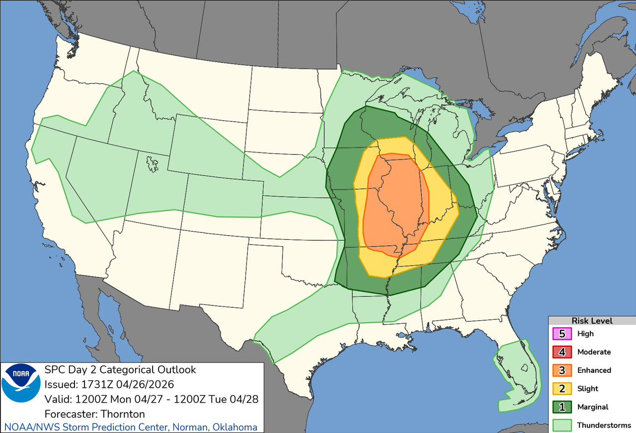
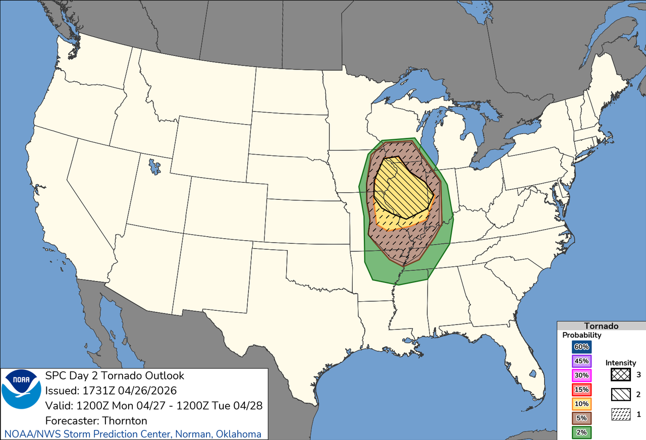
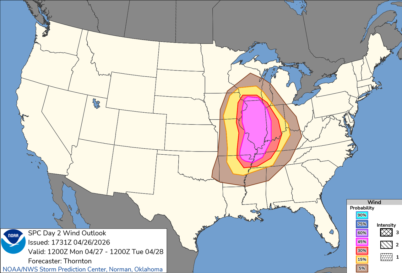
Severe weather outlook for tomorrow:
Posted on 4/26/26 at 10:54 pm to Roll Tide Ravens
Not often you see an entire state included in one of the elevated risk areas.
This post was edited on 4/26/26 at 10:54 pm
Posted on 4/26/26 at 10:57 pm to Pedro
We could see an upgrade to Moderate with the morning update.
Posted on 4/27/26 at 1:54 pm to LegendInMyMind
quote:
We could see an upgrade to Moderate with the morning update.

Posted on 4/27/26 at 2:26 pm to Roll Tide Ravens
Hopefully, we don't get a large outbreak
Posted on 4/27/26 at 6:49 pm to SidewalkTiger
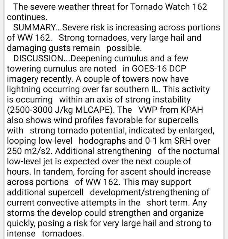
Just got home after being on the road all day and I’m surprised to see that SPC pulled the trigger on a PDS tornado watch, especially down into western TN.

URGENT - IMMEDIATE BROADCAST REQUESTED
Tornado Watch Number 162
NWS Storm Prediction Center Norman OK
245 PM CDT Mon Apr 27 2026
The NWS Storm Prediction Center has issued a
* Tornado Watch for portions of
Northeast Arkansas
Southern Illinois
Southern Indiana
Western Kentucky
Southeast Missouri
Western Tennessee
* Effective this Monday afternoon and evening from 245 PM until
1100 PM CDT.
...THIS IS A PARTICULARLY DANGEROUS SITUATION...
* Primary threats include...
Several tornadoes and a few intense tornadoes likely
Scattered large hail likely with isolated very large hail events
to 2.5 inches in diameter possible
Scattered damaging wind gusts to 70 mph likely
SUMMARY...Intense supercell development is expected to occur through
late afternoon, with a multi-round of severe storms expected to
occur across much of the region through this evening. As
deep-layer/low-level winds continue to strengthen, this includes the
potential for tornadoes, such of which are likely to be
strong/intense (EF2+/EF3+). Large hail and damaging winds are also
expected.
The tornado watch area is approximately along and 80 statute miles
east and west of a line from 45 miles west northwest of Evansville
IN to 10 miles east of Memphis TN.
This post was edited on 4/27/26 at 6:50 pm
Posted on 4/27/26 at 7:13 pm to Roll Tide Ravens
We gonna start a separate thread for tonight or roll with this one?
Posted on 4/27/26 at 7:19 pm to Wishnitwas1998
I’ve started a new one.
Posted on 4/27/26 at 7:30 pm to Roll Tide Ravens
quote:
Just got home after being on the road all day and I’m surprised to see that SPC pulled the trigger on a PDS tornado watch, especially down into western TN.
From the MCD for that watch:

 Page 6 of 6


Popular
Back to top