- My Forums
- Tiger Rant
- LSU Recruiting
- SEC Rant
- Saints Talk
- Pelicans Talk
- More Sports Board
- Coaching Changes
- Fantasy Sports
- Golf Board
- Soccer Board
- O-T Lounge
- Tech Board
- Home/Garden Board
- Outdoor Board
- Health/Fitness Board
- Movie/TV Board
- Book Board
- Music Board
- Political Talk
- Money Talk
- Fark Board
- Gaming Board
- Travel Board
- Food/Drink Board
- Ticket Exchange
- TD Help Board
Customize My Forums- View All Forums
- Show Left Links
- Topic Sort Options
- Trending Topics
- Recent Topics
- Active Topics
Started By
Message
 1
1

Posted on 11/29/22 at 11:07 am to trussthetruzz
And so it begins

Posted on 11/29/22 at 11:08 am to deltaland
Temp up to 68.5 at my location north of B'ham. Dew point at 56.
Posted on 11/29/22 at 11:14 am to Roll Tide Ravens
That severe warning near Amory is more interesting than the earlier one.
Posted on 11/29/22 at 11:14 am to Roll Tide Ravens
I'm pretty surprised by that shift
I'm pretty out of my depth with this set up but I really wasn't seeing how Tennsippibama was gonna get much severe development out of this
Our friends to the south however.....
I'm pretty out of my depth with this set up but I really wasn't seeing how Tennsippibama was gonna get much severe development out of this
Our friends to the south however.....
Posted on 11/29/22 at 11:17 am to Roll Tide Ravens
quote:
Meteorologist Nick Mikulas
Things continue to look like they’ll get quite rough today. These early showers weren’t expected to do much, but the heavier ones did exhibit some weak, mid level rotation. It appears the table is set for some to see multiple rounds of severe weather today, especially north of a DeRidder to Opelousas line.
I’ve already said pretty much everything that needs to be said. This has high end potential, and could bring all modes of severe weather. This is from the latest SPC update... “Present indications are that primary thunderstorm development will begin early this afternoon over parts of LA, spreading quickly into MS. This corridor may see multiple waves of severe convection as storms redevelop upstream through the evening.”
Again, multiple waves means that just because you experience a severe storm, you aren’t immune to seeing more rough weather. I’ve posted simulated radar images from the pretty consistent HRRR model at 3:00 and 7:00 PM showing the discrete nature of what will likely be supercell thunderstorms capable of producing tornadoes. This is a model representation, so it’s entirely likely these storms will be in slightly different positions, but this gives a good idea on the potential this afternoon brings. I’m rested up and ready to watch radar. I won’t be able to stream because I can’t say more than a few words without coughing. But I’ll be here analyzing, and posting all day.


Posted on 11/29/22 at 11:20 am to Wishnitwas1998
Already a discrete cell severe warned south of Tupelo
Little surprised this early but they throw the severe warnings out like candy so idk how significant it is. I wish I could see some severe thunderstorm warning FAR numbers. I bet it ain't pretty
Little surprised this early but they throw the severe warnings out like candy so idk how significant it is. I wish I could see some severe thunderstorm warning FAR numbers. I bet it ain't pretty

Posted on 11/29/22 at 11:24 am to Wishnitwas1998
Public schools in Memphis dismissing students early because of "rain".
Jesus tap dancing Christ.
Jesus tap dancing Christ.
Posted on 11/29/22 at 11:25 am to Wishnitwas1998
That storm should still be elevated. It looks to have a hail threat and maybe just enough wind.
Posted on 11/29/22 at 11:26 am to Rebel
quote:
Public schools in Memphis dismissing students early because of "rain".
That’s redundant that far north. Jackson I could understand but Memphis should mostly be fine
Posted on 11/29/22 at 11:28 am to Roll Tide Ravens
quote:
Consideration was made to introduce a small HIGH risk, but still too much uncertainty in the exact corridor of highest risk since moisture is not yet in place and there is no surface boundary to focus on.
The lack of boh large scale and mesoscale forcing has been the primary failure mode for the past few days. WAA showers may never get surfaced base but have enough coverage to keep things in check. However, there does appear to be a boundary setting up from Northern MS and sagging down through North LA and back along I20. That would be the area to watch for storms becoming surfaced based. Also, the lack of strong large scale forcing might favor discrete storm mode.

Posted on 11/29/22 at 11:31 am to LegendInMyMind
Well

Posted on 11/29/22 at 11:31 am to rds dc
quote:
However, there does appear to be a boundary setting up from Northern MS and sagging down through North LA and back along I20.
The HRRR picked that up pretty well. That's really the forcing at the moment, but more pre-frontal boundaries were evident as the afternoon/evening went on.
I think keeping an eye on any outflow boundaries is good idea, too.
This post was edited on 11/29/22 at 11:34 am
Posted on 11/29/22 at 11:31 am to Bobby OG Johnson
Yep. Figured that was coming.
Posted on 11/29/22 at 11:33 am to Bobby OG Johnson
quote:
Well
Matches up nicely with the apparent developing boundary and the 12z HREF.
Posted on 11/29/22 at 11:35 am to LegendInMyMind
In southwest Louisiana, it looks like we might get some straggling storms but will mostly miss the really bad stuff.
Posted on 11/29/22 at 11:37 am to deltaland
It also adds fuel to my grandmother's panic fire (she lives in east Memphis)
She watches the local news like it's her religion and takes absolutely everything they say as complete gospel so she thinks the end times are here
She watches the local news like it's her religion and takes absolutely everything they say as complete gospel so she thinks the end times are here
This post was edited on 11/29/22 at 11:38 am

Posted on 11/29/22 at 11:38 am to LegendInMyMind
How’s I12/10 looking for early afternoon?

Posted on 11/29/22 at 11:41 am to When in Rome
quote:
How’s I12/10 looking for early afternoon?
shitshow...but nothing to do with the weather
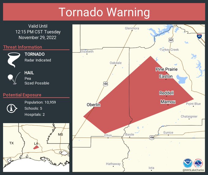
Posted on 11/29/22 at 11:45 am to BregmansWheelbarrow
CenLA is on the board
quote:
NWS Lake Charles @NWSLakeCharles
Tornado Warning including Mamou LA, Oberlin LA and Pine Prairie LA until 12:15 PM CST

 Page 6 of 21

Popular
Back to top