- My Forums
- Tiger Rant
- LSU Recruiting
- SEC Rant
- Saints Talk
- Pelicans Talk
- More Sports Board
- Fantasy Sports
- Golf Board
- Soccer Board
- O-T Lounge
- Tech Board
- Home/Garden Board
- Outdoor Board
- Health/Fitness Board
- Movie/TV Board
- Book Board
- Music Board
- Political Talk
- Money Talk
- Fark Board
- Gaming Board
- Travel Board
- Food/Drink Board
- Ticket Exchange
- TD Help Board
Customize My Forums- View All Forums
- Show Left Links
- Topic Sort Options
- Trending Topics
- Recent Topics
- Active Topics
Started By
Message
re: Tornado! Bama - State of Emergency - High Risk Portions of GA & SC
Posted on 4/5/17 at 9:40 am to Rhino5

Posted on 4/5/17 at 9:40 am to Rhino5
quote:
Almost all the surrounding counties near Columbus are shut down today
Interesting, didn't hear that. I don't remember severe weather shutdowns when I was a kid, but it's probably a good thing.
 1
1


Posted on 4/5/17 at 9:40 am to Pettifogger
Posted on 4/5/17 at 9:42 am to Pettifogger
quote:
. I don't remember severe weather shutdowns when I was a kid
Me neither that's what's sorta freaking me out. I remember snow days when a couple flurries hit but that's it
Posted on 4/5/17 at 9:45 am to Rhino5
We're getting some torrential rain here in Cobb County. Hasn't been too bad yet though. I'm working from home today and now I'm regretting it. 
Posted on 4/5/17 at 9:46 am to Rhino5
quote:
Me neither that's what's sorta freaking me out. I remember snow days when a couple flurries hit but that's it
Seems to me it has mostly started post Tuscaloosa (and maybe Enterprise). My best guess is that for today, they just didn't have any set timing for the storms that would allow for planning and contingencies.
Posted on 4/5/17 at 9:46 am to Rhino5
quote:
Me neither that's what's sorta freaking me out. I remember snow days when a couple flurries hit but that's it
I think it's more of an understanding of the weather conditions that lead to tornadoes... they can better pinpoint the "dangerous days ahead" (in the words of storm chaser Tim Samaras... which he tweeted out the night before the El Reno, OK tornado that killed him, his son, and his chase partner)

Posted on 4/5/17 at 9:46 am to rds dc
Nashville storm chance just decreased according to my trusty weather app.

edit to remove "rain chance down". Missed the 4:00 PM hour for 60% chance of rainstorm. With thanks, it's still been significantly lowered for storm activity today.
edit to remove "rain chance down". Missed the 4:00 PM hour for 60% chance of rainstorm. With thanks, it's still been significantly lowered for storm activity today.
This post was edited on 4/5/17 at 12:03 pm

Posted on 4/5/17 at 9:54 am to rt3
It seems like a smart idea to me. I have to imagine a tornado hitting a major city during rush hour is pretty much the nightmare scenario, so the fewer folks out and about during high tornado risk days, the better.
Posted on 4/5/17 at 9:57 am to HogX
Uograde to High Risk being considered:

Mesoscale Discussion 0440
NWS Storm Prediction Center Norman OK
0943 AM CDT Wed Apr 05 2017
Areas affected...Portions of AL/GA/SC
Concerning...Outlook upgrade
Valid 051443Z - 051645Z
SUMMARY...Portions of the states of AL/GA/SC are being considered
for an Outlook upgrade -- though the details are still being
analyzed. A very notable dry bias is apparent in the latest model
guidance, and observational data and previous model runs are being
heavily referenced in Outlook preparation.
DISCUSSION...GPS PW data are exhibiting a low bias by at least 0.5
inch from parts of AL into GA, which has influenced initialization
of the latest numerical weather prediction guidance. Per
coordination with the Weather Prediction Center, it appears that
related initialization is causing substantial dry biases in model
guidance -- extended through the Day 1 forecast period. With an
inland influx of rich moisture feeding ongoing intense supercells in
southern AL (with dewpoints into the middle 70s), and the
around-16.6-g/kg mean mixing ratio per LIX 12Z sounding, and around
1.5-inch PW per Atlanta and Birmingham 12Z soundings, it is evident
that rich moisture and related strong buoyancy does indeed extend
inland. As such, observational data and previous model runs will
play a major role in the consideration for a High Risk upgrade, as
the dry bias has influenced the latest model guidance. While an
Outlook upgrade is possible, it is not certain.
Posted on 4/5/17 at 9:59 am to BestBanker
Looking like those southern cells are going to travel right up I-85 or just south of it

Posted on 4/5/17 at 9:59 am to rds dc
Bout to get rough here in Lexington
Posted on 4/5/17 at 10:01 am to rds dc
quote:
notable dry bias
sounds kinky
Posted on 4/5/17 at 10:09 am to rds dc
What does that mean RDS?
Looks like Atlanta proper is right on the line of being included/not
Looks like Atlanta proper is right on the line of being included/not
Posted on 4/5/17 at 10:15 am to Pettifogger
I let my ATL friends know yesterday about todays threat.
I missed out on a Tornado by about 40 miles yesterday. Goodman, MO was struck head on.


I missed out on a Tornado by about 40 miles yesterday. Goodman, MO was struck head on.
This post was edited on 4/5/17 at 10:20 am

Posted on 4/5/17 at 10:16 am to Pettifogger
quote:
What does that mean RDS?
Posted on 4/5/17 at 10:29 am to Pettifogger
I think Enterprise got school systems attention and then April 11 tornadoes got everybody's attention. As more and more people are able to work from home it becomes an easier thing to go ahead and shut stuff down too, so technology plays a part.
Maybe to a smaller degree, but I think the snow in 2014 also changed some opinions on shutting down for severe weather
Maybe to a smaller degree, but I think the snow in 2014 also changed some opinions on shutting down for severe weather
Posted on 4/5/17 at 10:31 am to BottomlandBrew
quote:
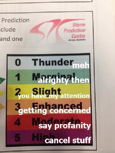
I would change "cancel stuff" to either "hide" or "put on medieval armor suit"
Posted on 4/5/17 at 10:32 am to Pettifogger
quote:
What does that mean RDS?
quote:
DISCUSSION...GPS PW data are exhibiting a low bias by at least 0.5
inch from parts of AL into GA, which has influenced initialization
of the latest numerical weather prediction guidance.
GPS data is put through radio occulation to measure the Doppler shift in the GPS data to determine atmospheric moisture content. Simple version, they can us GPS data to tell models how much water is in the air. That isn't working properly today and it is f'ing up the models.
Posted on 4/5/17 at 10:42 am to rds dc
What usually happens in Alabama, at least around Birmingham, is one of the larger school systems cancels, and the rest follow suit. My wife worked for Jefcoed and they have schools scattered all over the county, so they can’t just say “Schools XYZ” is cancelled today, but the rest of you teachers and students have to show up. So they cancel or call school early, and then you’ll have Hoover, Vestavia, Homewood etc all start cancelling as well. I think it was actually Hoover that called it first with today’s forecast. It was supposed to hit pretty hard between 3-5 AM, and it sort of did, just without any tornado activity. I still had to work, but my drive in this morning around 7:30 was pretty hairy. Some areas a light drizzle, others a torrential downpour. You don’t want kids on busses during all that, combined with the normal carpool traffic of parents dropping off, and especially inexperienced teenage drivers at high schools.
Posted on 4/5/17 at 11:11 am to Pettifogger
Tornado warning in Stewart and Randolph county GA

 Page 4 of 18

Popular
Back to top