- My Forums
- Tiger Rant
- LSU Recruiting
- SEC Rant
- Saints Talk
- Pelicans Talk
- More Sports Board
- Coaching Changes
- Fantasy Sports
- Golf Board
- Soccer Board
- O-T Lounge
- Tech Board
- Home/Garden Board
- Outdoor Board
- Health/Fitness Board
- Movie/TV Board
- Book Board
- Music Board
- Political Talk
- Money Talk
- Fark Board
- Gaming Board
- Travel Board
- Food/Drink Board
- Ticket Exchange
- TD Help Board
Customize My Forums- View All Forums
- Show Left Links
- Topic Sort Options
- Trending Topics
- Recent Topics
- Active Topics
Started By
Message
re: SW LA getting rocked by severe storms this morning.
Posted on 5/17/21 at 7:58 pm to Bobby OG Johnson

Posted on 5/17/21 at 7:58 pm to Bobby OG Johnson
This dinosaur looks ominous and his a-hole is on his side hip.
 2
2


Posted on 5/17/21 at 8:01 pm to redstick13
quote:
Weather Intercepts
@Wx_Intercepts
Incredible storm northeast of Sterling City, TX at 7:54pm

Posted on 5/17/21 at 8:03 pm to LegendInMyMind
quote:
54 (give or take) chasers on that storm.
There have been a couple of these storms turning today. I know that one has made it's right turn already but there have been a couple that have turned toward a cluster of chasers today.

Posted on 5/17/21 at 8:03 pm to Bobby OG Johnson
Those wind turbines gonna eat

Posted on 5/17/21 at 8:03 pm to Bobby OG Johnson
Anyone have any information on how things are going in LC? The rain has finally slacked off the last couple hours.

Posted on 5/17/21 at 8:04 pm to redstick13
He's lifting his leg to projectile shite on California
Posted on 5/17/21 at 8:05 pm to Bobby OG Johnson
Panorama of same storm:
@Zanzibar2251
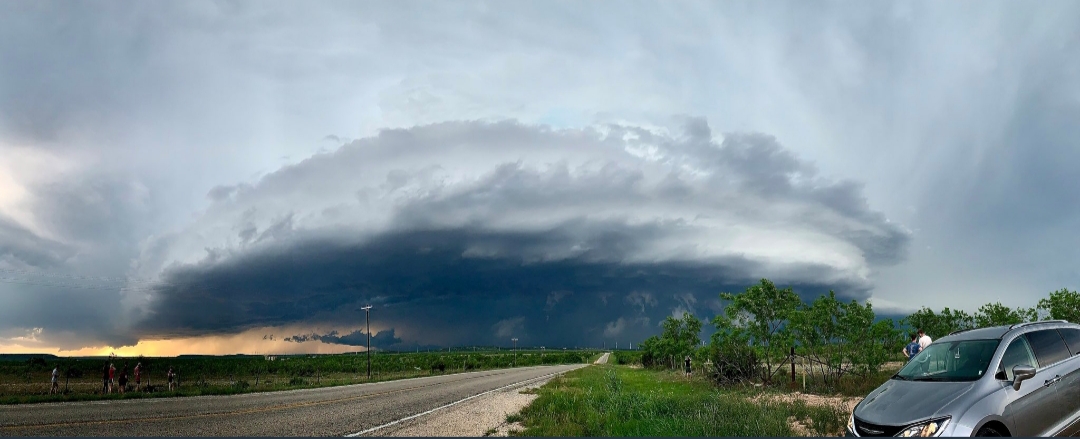
@Zanzibar2251
Posted on 5/17/21 at 8:05 pm to Bobby OG Johnson

Posted on 5/17/21 at 8:05 pm to Bobby OG Johnson
quote:
Spotr 12 miles N of STERLING CITY, TX @ 01:03 UTC TOR>-Tornado crossed 163 at Lucid Energy Silver Plant approximately 15 minutes ago. Dam

Posted on 5/17/21 at 8:06 pm to sledgehammer
Water going down slow. Lots of homes and businesses flooded. Some that were just rebuilt from Laura, others that haven’t been touched. Lots of campers blown over that people were living in.
The hospital on gautier is in worse shape than it was for the hurricanes. Standing water in some of the offices.
The hospital on gautier is in worse shape than it was for the hurricanes. Standing water in some of the offices.
Posted on 5/17/21 at 8:06 pm to Duke
quote:
There have been a couple of these storms turning today. I know that one has made it's right turn already but there have been a couple that have turned toward a cluster of chasers today.
Cameron Nixon posted that screen grab and tweeted:
quote:
Chasers PLEASE beware of sudden track deviations E/NE. Very dangerous storm LINK
He's been deep dive studying deviant storm motion for a while now.
This post was edited on 5/17/21 at 8:07 pm
Posted on 5/17/21 at 8:07 pm to Bobby OG Johnson
Posted on 5/17/21 at 8:08 pm to LegendInMyMind
Is it going to be this bad in LC area all week? I’m not sure how much more we can take.
Posted on 5/17/21 at 8:09 pm to DiamondDog
quote:
Is it going to be this bad in LC area all week?
The models struggle to forecast rain amounts
Posted on 5/17/21 at 8:09 pm to DiamondDog
quote:
Is it going to be this bad in LC area all week? I’m not sure how much more we can take.
There's going to be rain and storms, hopefully not like today, though.
Posted on 5/17/21 at 8:10 pm to Bobby OG Johnson
quote:
Spotr 2 miles ESE of WOLFFORTH, TX @ 01:08 UTC Funnel>-Long slender rope funnel halfway to the ground a couple miles W of me.
Posted on 5/17/21 at 8:10 pm to Bobby OG Johnson
KMAF radar is still down and it looks like KLBB is going to have a close call with a tornado warned storm in a few minutes.
Posted on 5/17/21 at 8:11 pm to Bobby OG Johnson
quote:
@Jeff_Piotrowski
Tornado crossed HWY 163 hit gas power plant with damage. 15 NW of Sterling City.

Posted on 5/17/21 at 8:11 pm to DiamondDog
quote:
Is it going to be this bad in LC area all week? I’m not sure how much more we can take.
Tomorrow looks sorta ok but the rest of the week looks like shite
Posted on 5/17/21 at 8:12 pm to Bobby OG Johnson
That storm approaching Lubbock is holding together so far. At least some large hail in populated areas. Hopefully no tornado reaches the ground.
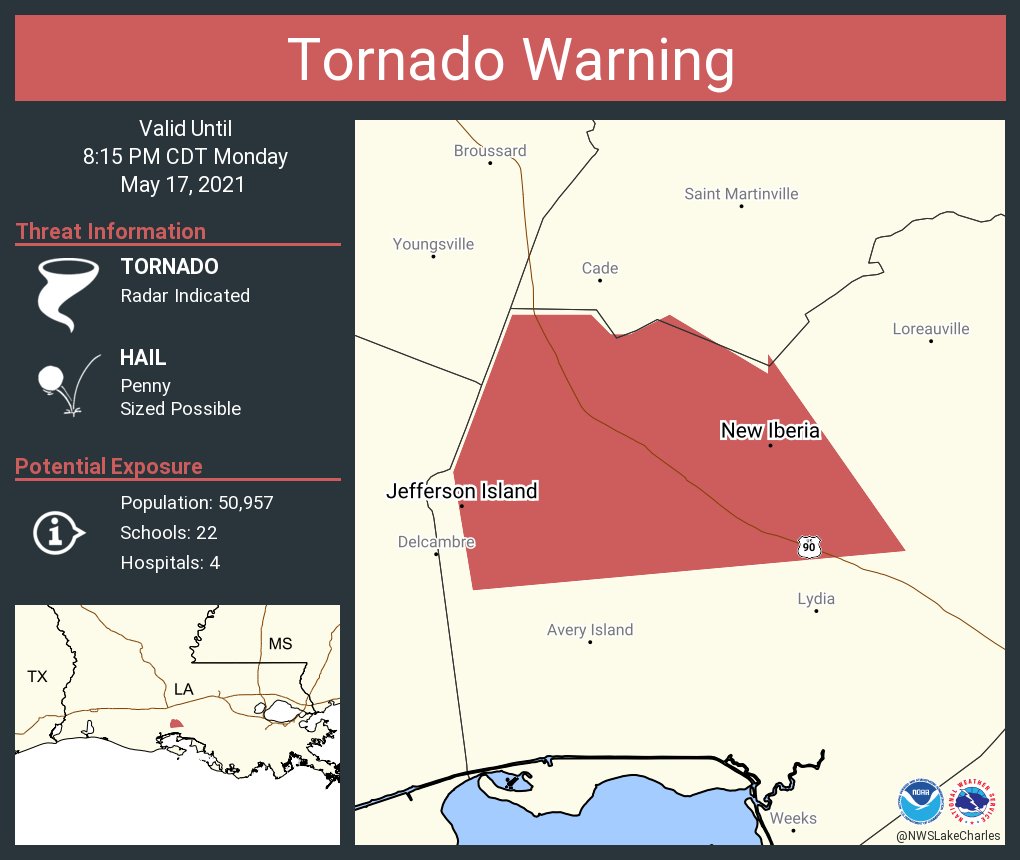
Severe Weather Statement
National Weather Service Lubbock TX
803 PM CDT Mon May 17 2021
TXC219-303-180130-
/O.CON.KLUB.TO.W.0027.000000T0000Z-210518T0130Z/
Lubbock TX-Hockley TX-
803 PM CDT Mon May 17 2021
...A TORNADO WARNING REMAINS IN EFFECT UNTIL 830 PM CDT FOR
SOUTHWESTERN LUBBOCK AND EAST CENTRAL HOCKLEY COUNTIES...
At 803 PM CDT, a severe thunderstorm capable of producing a tornado
was located over Wolfforth, or 8 miles west of Lubbock, moving east
at 25 mph.
HAZARD...Tornado and tennis ball size hail.
SOURCE...Radar indicated rotation.
IMPACT...Flying debris will be dangerous to those caught without
shelter. Mobile homes will be damaged or destroyed. Damage
to roofs, windows, and vehicles will occur. Tree damage is
likely.
Locations impacted include...
Lubbock, Wolfforth, Shallowater, Lubbock International Airport, Texas
Tech University, Downtown Lubbock, Lubbock South Plains Mall, Reese
Center, New Deal and Lubbock Science Spectrum.
PRECAUTIONARY/PREPAREDNESS ACTIONS...
TAKE COVER NOW! Move to a basement or an interior room on the lowest
floor of a sturdy building. Avoid windows. If you are outdoors, in a
mobile home, or in a vehicle, move to the closest substantial shelter
and protect yourself from flying debris.
&&
LAT...LON 3350 10212 3366 10208 3373 10181 3346 10178
TIME...MOT...LOC 0103Z 267DEG 23KT 3353 10203
TORNADO...RADAR INDICATED
HAIL...2.50IN

 Page 16 of 66

Popular
Back to top