- My Forums
- Tiger Rant
- LSU Recruiting
- SEC Rant
- Saints Talk
- Pelicans Talk
- More Sports Board
- Fantasy Sports
- Golf Board
- Soccer Board
- O-T Lounge
- Tech Board
- Home/Garden Board
- Outdoor Board
- Health/Fitness Board
- Movie/TV Board
- Book Board
- Music Board
- Political Talk
- Money Talk
- Fark Board
- Gaming Board
- Travel Board
- Food/Drink Board
- Ticket Exchange
- TD Help Board
Customize My Forums- View All Forums
- Show Left Links
- Topic Sort Options
- Trending Topics
- Recent Topics
- Active Topics
Started By
Message
re: Storm Tracking Thread: Post Tropical Storm Hermine
Posted on 8/24/16 at 7:03 am to geauxtigersgirl
Posted on 8/24/16 at 7:03 am to geauxtigersgirl
Hunh?
 2
2


Posted on 8/24/16 at 7:04 am to Janky
See it now
This post was edited on 8/24/16 at 7:08 am
Posted on 8/24/16 at 7:05 am to Janky
(no message)
This post was edited on 5/13/21 at 10:58 pm
Posted on 8/24/16 at 7:05 am to Bama and Beer
How many more projected paths do you need?
Posted on 8/24/16 at 7:06 am to Zach Lee To Amp Hill
A bunch
Eta. I see it on previous page
Eta. I see it on previous page
This post was edited on 8/24/16 at 7:07 am
Posted on 8/24/16 at 7:06 am to rds dc
Just a reminder, there is still plenty of reason to take anything you see over the next couple of days with a grain of salt. The system hasn't formed and there is still a lot of spread across the models. View the interwebz with caution and be highly skeptical of anyone posting an actual forecast at this point.
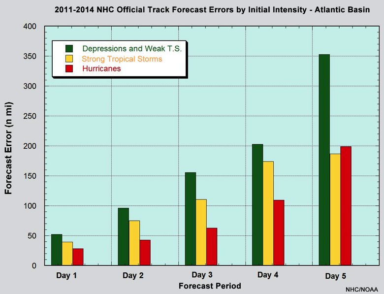
Track error would be even worse for invest, if they were included in this graphic:
Here is a product that WSI posted this morning showing the last 4 Euro EPS runs, a shift west but still a large spread:

Track error would be even worse for invest, if they were included in this graphic:
Here is a product that WSI posted this morning showing the last 4 Euro EPS runs, a shift west but still a large spread:
Posted on 8/24/16 at 7:06 am to geauxtigersgirl
On that map, is that where they are predicting landfall? I am not sure how to read the map. I thought it was a current storm position.

Posted on 8/24/16 at 7:09 am to Janky
projected path but a pretty wide spread

Posted on 8/24/16 at 7:10 am to Janky
Yes that is a projected landfall.
Coukd be wildly inaccurate since the storm isn't developed yet, so don't freak out. But keep an eye out and begin some prep
Coukd be wildly inaccurate since the storm isn't developed yet, so don't freak out. But keep an eye out and begin some prep
Posted on 8/24/16 at 7:11 am to Janky
Can you imagine 90+ mph winds with all the piles of debris everywhere.
Posted on 8/24/16 at 7:13 am to Hulkklogan
Oh, I won't freak out. I will lock my shite up and head to Toledo bend.
Posted on 8/24/16 at 7:16 am to Janky
I've gathered that this would make landfall around Wed AM, is that fair to say?

Posted on 8/24/16 at 7:17 am to Rebel
quote:
That seems like a silly name.
Even more silly, is that it's pronounced Her-MEEN

Posted on 8/24/16 at 7:19 am to gsvar2004
quote:
Can you imagine 90+ mph winds with all the piles of debris everywhere.
this along with the areas that still have water in ditches and ponds that haven't drained yet due to the backflow.

Posted on 8/24/16 at 7:24 am to 4WHLN
quote:
Can you imagine 90+ mph winds with all the piles of debris everywhere.
this along with the areas that still have water in ditches and ponds that haven't drained yet due to the backflow.
That's what we were saying after Cindy hit and Katrina was about to hit Florida.
Posted on 8/24/16 at 7:29 am to t00f
99L is approximately 1660 mile SE of Beaufort SC tracking WNW at 15 mph over the St Maarten, Barbuda, Anguilla et. al. .Convection is better organized this morning than yesterday despite the fact that 99L is pushing against a big slug of dry air. 99L remains challenged by aforementioned dry air and island topography of Puerto Rico and Hispaniola keeping intensity in check for at least 48 hours. Conditions become more favorable for 99L to rapidly intensify near the northern Bahamas and the coast of Florida. In our favor, a strong ridge of high pressure builds in over the US east coast that would “persuade” 99L or its named successor to remain a more westerly track into the GoMex, a la Hurricanes Andrew and Katrina, and if you recall that did not end well. Despite the lack of a well-defined center of circulation, the models have an eerily good near consensus on a westerly track in to the GoMex on Sunday.
This post was edited on 8/24/16 at 7:29 am

Posted on 8/24/16 at 7:33 am to gsvar2004
quote:
Can you imagine 90+ mph winds with all the piles of debris everywhere.
That is terrifying

Posted on 8/24/16 at 7:36 am to GEAUXmedic
So not Her-miney?
Posted on 8/24/16 at 7:41 am to slackster
Is it ok to be kinda relieved that Louisiana is in the bullseye? With a storm this far out, chances have to be very slim that it actually ends up where they are predicting. Could we see more westerly shift?
Posted on 8/24/16 at 7:42 am to RidiculousHype
At least you can use homeowners to cover damages. No flood insurance? Go pull shingles off your roof and have a tree "accidentally" fall on your house.
Problem solved
Problem solved
This post was edited on 8/24/16 at 7:50 am

 Page 29 of 175

Popular
Back to top