- My Forums
- Tiger Rant
- LSU Recruiting
- SEC Rant
- Saints Talk
- Pelicans Talk
- More Sports Board
- Coaching Changes
- Fantasy Sports
- Golf Board
- Soccer Board
- O-T Lounge
- Tech Board
- Home/Garden Board
- Outdoor Board
- Health/Fitness Board
- Movie/TV Board
- Book Board
- Music Board
- Political Talk
- Money Talk
- Fark Board
- Gaming Board
- Travel Board
- Food/Drink Board
- Ticket Exchange
- TD Help Board
Customize My Forums- View All Forums
- Show Left Links
- Topic Sort Options
- Trending Topics
- Recent Topics
- Active Topics
Started By
Message
re: Storm Aftermath - Hurricane Matthew will be Retired
Posted on 9/26/16 at 5:15 pm to dabigfella
Posted on 9/26/16 at 5:15 pm to dabigfella
I'm no weather man so don't hold me to it. 
 0
0


Posted on 9/26/16 at 5:27 pm to rds dc
All the spaghetti plots are pointing to the Gulf, and we're a week and a day out...
Que the "armchair meteorologists" meltdown....

Que the "armchair meteorologists" meltdown....
Posted on 9/26/16 at 5:37 pm to lsuman25
quote:
ugh,hopefully data tomorrow from the hurricane hunters gives us a better idea with the models
Hopefully, they find a rapidly organizing system. The sooner this strengthens the more likely it is to take the first exit opportunity. The GFS has been pretty consistent with getting this going early on. I have some reasons to believe the GFS is being overly aggressive with development but will be glad to be proven wrong
Posted on 9/26/16 at 5:49 pm to rds dc
Going to Florida panhandle on Oct 9th. Be an issue?
Posted on 9/26/16 at 5:58 pm to rds dc

Posted on 9/26/16 at 6:10 pm to DustyDinkleman
quote:
All the spaghetti plots are pointing to the Gulf, and we're a week and a day out.
Looks like a fish to me with a cold front bending it out.
Posted on 9/26/16 at 6:16 pm to t00f
The Euro is troubling but it has been pretty horrible this season. However, I am seeing other models slowly coming around. I think the GFS is simply out to lunch.
Even if the Euro is right and this comes west, maybe even making it to the gulf via the Yucatan channel, odds are that a trough will pick it up and swing it to our east but while this will be October it will still be early October and it is also possible that it gets picked up just enough to start heading NW and never really hooks to the East, which would be quite bad for us depending when that happens.
I think it has a quite low chance of coming to LA but the chance is there so I will keep watching.
Posted on 9/26/16 at 8:33 pm to rds dc
rds is this for real??
Posted on 9/26/16 at 8:49 pm to BigB0882
Another slight shift westward with the early 00z models:

Posted on 9/26/16 at 9:04 pm to tiger91
quote:
is this for real??
Like real clouds out over the ocean? Yes. Like a real threat for Louisiana, the Gulf, Florida, etc? No one can really say at this point. There is a lot of uncertainty regarding the future track of the system.
Posted on 9/26/16 at 10:11 pm to lsuman25
quote:
Doesn't a system that is not a strong system tend to not do well in the eastern Caribbean?
Yes, but climo suggest that the unfavorable conditions should start to lessen as we move into October but the data points to it still being pretty unfavorable over the next two weeks.
This is showing when systems were first named during the last week of September:

and the first week of October:

So, there is a pretty signifiant dead spot from about 63W over to 73W. So will it get a name before 63W? That is certainly an intriguing question and genesis forecasting is still one of the areas that the models and everyone else still struggles with
There area a few clues as to what might be going on. The 00z Best Track has this near 10N 50W:

and currently all the deep convection is pretty far to the north associated with some stronger shear.

Then add to that that this still has a pretty big circulation that is going to take time to consolidate and genesis doesn't seem imminent.

I saw some calls today for this to be a named system in the morning. While that certainly could happen, it would take a sustained burst of deep convection near the center overnight. Can that happen? Who knows but the current back ground state of the MDR is being surpressed by the MJO:

The top panel is for today, it shows a suppressed MJO state for the MDR (orange shaded areas). However, there is a KW pushing across the basin (blue contours) and it should be superimposed over 97L later this evening or tomorrow. That should help to counter the background state and give convection a nice boost. Current research suggest that the most favorable conditions for genesis occur around 2 or 3 days after passage of a KW. So that would put genesis occurring pretty close to the beginning of the 63W dead zone.
Another look at analysis of the KW shows it but maybe not as robust as the image above:

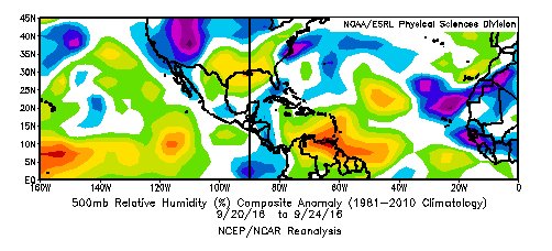
However, the timing is in agreement b/w the two different analysis tools. So that is a pretty strong signal for possibly more favorable conditions for genesis as the system nears 60-63W. Another thing, NOAA ESRL shows a lot of mid-level dry air out ahead and to the SW of the system. That could also slow development:
TL, DR - who knows but NHC has the odds at 90% over the next 5 days and recon should fly tomorrow
Posted on 9/26/16 at 10:18 pm to rds dc
Posted on 9/26/16 at 10:31 pm to rds dc
That may be one of the most technical post ever made on here. .01% of TD users understand any of that.
Show off
Show off

Posted on 9/26/16 at 10:44 pm to FelicianaTigerfan
I usually just read his helpful summaries at the bottom and ignore all the pretty colors
Posted on 9/27/16 at 6:22 am to Aspercel
quote:
I usually just read his helpful summaries at the bottom and ignore all the pretty colors
And I though I was the only one that did that.
Posted on 9/27/16 at 7:56 am to fishfighter
The westward trend in the models continued overnight with the GFS going from Bermuda yesterday to the East Coast overnight. There was a slight shift with the Euro package and the 00z Euro is still on the eastern side of that guidance but not as far as previous runs.
The 00z Euro EPS has this near the western tip of Cuba at D10 with the members being pretty tightly clustered between Louisiana and Florida.
00z Euro EPS @ D10:

The kicker trough that was coming in from the west was a lot less pronounced in the 00z Euro EPS run with the D10 steering pattern a bit more concerning:

Recon flies today and it will be interesting to see if they can close off the system with some west winds making it a large Pacific like depression or if its still an open wave.
The 00z Euro EPS has this near the western tip of Cuba at D10 with the members being pretty tightly clustered between Louisiana and Florida.
00z Euro EPS @ D10:
The kicker trough that was coming in from the west was a lot less pronounced in the 00z Euro EPS run with the D10 steering pattern a bit more concerning:
Recon flies today and it will be interesting to see if they can close off the system with some west winds making it a large Pacific like depression or if its still an open wave.
Posted on 9/27/16 at 8:14 am to rds dc
quote:
The kicker trough that was coming in from the west was a lot less pronounced in the 00z Euro EPS run with the D10 steering pattern a bit more concerning:
quote:
between Louisiana and Florida.


Posted on 9/27/16 at 8:23 am to meauxjeaux2
WTF

Posted on 9/27/16 at 8:23 am to meauxjeaux2
Crazy stuff
ETA: Damn you Cosmo
This post was edited on 9/27/16 at 8:24 am
Posted on 9/27/16 at 8:24 am to ForeverLSU02

 Page 7 of 181

Popular
Back to top