- My Forums
- Tiger Rant
- LSU Recruiting
- SEC Rant
- Saints Talk
- Pelicans Talk
- More Sports Board
- Fantasy Sports
- Golf Board
- Soccer Board
- O-T Lounge
- Tech Board
- Home/Garden Board
- Outdoor Board
- Health/Fitness Board
- Movie/TV Board
- Book Board
- Music Board
- Political Talk
- Money Talk
- Fark Board
- Gaming Board
- Travel Board
- Food/Drink Board
- Ticket Exchange
- TD Help Board
Customize My Forums- View All Forums
- Show Left Links
- Topic Sort Options
- Trending Topics
- Recent Topics
- Active Topics
Started By
Message
re: Storm Aftermath - Hurricane Matthew will be Retired
Posted on 10/6/16 at 10:00 pm to tigerskin
Posted on 10/6/16 at 10:00 pm to tigerskin
quote:
So what's the latest summary and expectations? Thanks
11:00 pm EST update from NHC is out but they are having some issues with the website it appears. That will be the best source for an update. Matthew is on the eastern side of the guidance envelope at this time but it is impossible to tell if that will hold.
 2
2

Posted on 10/6/16 at 10:01 pm to ReauxlTide222
quote:
My cousin lives there(St. John's Island), and is staying. She doesn't seem concerned at all.
John's Island is a big island and has a good bit of high ground unless you're right on the marsh, IC, or river. Not a bad place to stay but getting power back will be a bitch. I live on the island directly east of that. Almost all of my neighbors are staying put - they were here in Hugo and said the neighborhood wasn't even close to getting significant water.
Posted on 10/6/16 at 10:02 pm to rds dc
From the 11:00 pm EST NHC advisory:
Posted on 10/6/16 at 10:03 pm to rds dc
ZCZC MIATCDAT4 ALL
TTAA00 KNHC DDHHMM
HURRICANE MATTHEW DISCUSSION NUMBER 36
NWS NATIONAL HURRICANE CENTER MIAMI FL AL142016
1100 PM EDT THU OCT 06 2016
The satellite appearance of Matthew has improved during the past
several hours, with an eye embedded within a more circular central
dense overcast and an increase in the outer banding. Reports from
a NOAA Hurricane Hunter aircraft and coastal radar data show the
presence of centric eyewalls with diameters of about 8 and 60 n mi
respectively. The NOAA aircraft earlier reported a minimum pressure
of 937 mb, and an Air Force Reserve Hurricane Hunter just reported
estimated surface winds of 109 kt from the SFMR and a pressure of
939 mb. Based on these data, the initial intensity is 115 kt.
The initial motion is 325/11 kt. For the next 24-48 hours, Matthew
should move around the western end of the subtropical ridge, with
the motion gradually turning northward and then northeastward.
During this time, the center of the guidance envelope and the
various consensus models have shifted a little to the east. However,
the ECMWF, GFS, and UKMET continue to suggest the possibility of the
hurricane making landfall in Florida and then moving near the coasts
of Georgia and South Carolina. This part of the forecast is nudged
a little to the east and lies between the model consensus and the
previous forecast. After 48 hours, a mid- to upper-level ridge is
forecast to build north and west of Matthew, and the track guidance
forecasts a southeasterly to southerly motion in response. While
there is still a large spread, the GFS, ECMWF, and UKMET are in
better agreement that Matthew should move south between the ridge
and Hurricane Nicole to the east. This part of the forecast follows
this guidance and lies between the GFS and ECMWF.
During the next 12-24 hours, Matthew will likely weaken a little as
it undergoes an eyewall replacement cycle. After that time, it is
expected to encounter strong southwesterly vertical shear, and later
in the forecast period dry air is likely to entrain into the
cyclone. This combination should cause steady weakening, and
Matthew is forecast to drop below hurricane strength by 72 hours.
The new intensity forecast is in best agreement with the SHIPS
model.
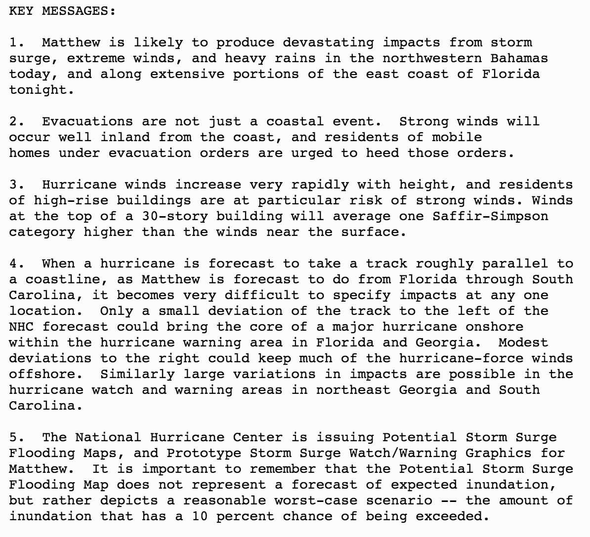
KEY MESSAGES:
1. Matthew is likely to produce devastating impacts from storm
surge, extreme winds, and heavy rains in the northwestern Bahamas
today, and along extensive portions of the east coast of Florida
tonight.
2. Evacuations are not just a coastal event. Strong winds will
occur well inland from the coast, and residents of mobile
homes under evacuation orders are urged to heed those orders.
3. Hurricane winds increase very rapidly with height, and residents
of high-rise buildings are at particular risk of strong winds. Winds
at the top of a 30-story building will average one Saffir-Simpson
category higher than the winds near the surface.
4. When a hurricane is forecast to take a track roughly parallel to
a coastline, as Matthew is forecast to do from Florida through South
Carolina, it becomes very difficult to specify impacts at any one
location. Only a small deviation of the track to the left of the
NHC forecast could bring the core of a major hurricane onshore
within the hurricane warning area in Florida and Georgia. Modest
deviations to the right could keep much of the hurricane-force winds
offshore. Similarly large variations in impacts are possible in the
hurricane watch and warning areas in northeast Georgia and South
Carolina.
5. The National Hurricane Center is issuing Potential Storm Surge
Flooding Maps, and Prototype Storm Surge Watch/Warning Graphics for
Matthew. It is important to remember that the Potential Storm Surge
Flooding Map does not represent a forecast of expected inundation,
but rather depicts a reasonable worst-case scenario -- the amount of
inundation that has a 10 percent chance of being exceeded.
FORECAST POSITIONS AND MAX WINDS
INIT 07/0300Z 27.1N 79.2W 115 KT 130 MPH
12H 07/1200Z 28.5N 80.2W 110 KT 125 MPH
24H 08/0000Z 30.3N 80.8W 105 KT 120 MPH
36H 08/1200Z 31.8N 80.2W 90 KT 105 MPH
48H 09/0000Z 32.6N 78.7W 75 KT 85 MPH
72H 10/0000Z 31.5N 75.5W 60 KT 70 MPH
96H 11/0000Z 29.0N 75.5W 50 KT 60 MPH
120H 12/0000Z 27.0N 77.0W 40 KT 45 MPH
$$
Forecaster Beven
TTAA00 KNHC DDHHMM
HURRICANE MATTHEW DISCUSSION NUMBER 36
NWS NATIONAL HURRICANE CENTER MIAMI FL AL142016
1100 PM EDT THU OCT 06 2016
The satellite appearance of Matthew has improved during the past
several hours, with an eye embedded within a more circular central
dense overcast and an increase in the outer banding. Reports from
a NOAA Hurricane Hunter aircraft and coastal radar data show the
presence of centric eyewalls with diameters of about 8 and 60 n mi
respectively. The NOAA aircraft earlier reported a minimum pressure
of 937 mb, and an Air Force Reserve Hurricane Hunter just reported
estimated surface winds of 109 kt from the SFMR and a pressure of
939 mb. Based on these data, the initial intensity is 115 kt.
The initial motion is 325/11 kt. For the next 24-48 hours, Matthew
should move around the western end of the subtropical ridge, with
the motion gradually turning northward and then northeastward.
During this time, the center of the guidance envelope and the
various consensus models have shifted a little to the east. However,
the ECMWF, GFS, and UKMET continue to suggest the possibility of the
hurricane making landfall in Florida and then moving near the coasts
of Georgia and South Carolina. This part of the forecast is nudged
a little to the east and lies between the model consensus and the
previous forecast. After 48 hours, a mid- to upper-level ridge is
forecast to build north and west of Matthew, and the track guidance
forecasts a southeasterly to southerly motion in response. While
there is still a large spread, the GFS, ECMWF, and UKMET are in
better agreement that Matthew should move south between the ridge
and Hurricane Nicole to the east. This part of the forecast follows
this guidance and lies between the GFS and ECMWF.
During the next 12-24 hours, Matthew will likely weaken a little as
it undergoes an eyewall replacement cycle. After that time, it is
expected to encounter strong southwesterly vertical shear, and later
in the forecast period dry air is likely to entrain into the
cyclone. This combination should cause steady weakening, and
Matthew is forecast to drop below hurricane strength by 72 hours.
The new intensity forecast is in best agreement with the SHIPS
model.
KEY MESSAGES:
1. Matthew is likely to produce devastating impacts from storm
surge, extreme winds, and heavy rains in the northwestern Bahamas
today, and along extensive portions of the east coast of Florida
tonight.
2. Evacuations are not just a coastal event. Strong winds will
occur well inland from the coast, and residents of mobile
homes under evacuation orders are urged to heed those orders.
3. Hurricane winds increase very rapidly with height, and residents
of high-rise buildings are at particular risk of strong winds. Winds
at the top of a 30-story building will average one Saffir-Simpson
category higher than the winds near the surface.
4. When a hurricane is forecast to take a track roughly parallel to
a coastline, as Matthew is forecast to do from Florida through South
Carolina, it becomes very difficult to specify impacts at any one
location. Only a small deviation of the track to the left of the
NHC forecast could bring the core of a major hurricane onshore
within the hurricane warning area in Florida and Georgia. Modest
deviations to the right could keep much of the hurricane-force winds
offshore. Similarly large variations in impacts are possible in the
hurricane watch and warning areas in northeast Georgia and South
Carolina.
5. The National Hurricane Center is issuing Potential Storm Surge
Flooding Maps, and Prototype Storm Surge Watch/Warning Graphics for
Matthew. It is important to remember that the Potential Storm Surge
Flooding Map does not represent a forecast of expected inundation,
but rather depicts a reasonable worst-case scenario -- the amount of
inundation that has a 10 percent chance of being exceeded.
FORECAST POSITIONS AND MAX WINDS
INIT 07/0300Z 27.1N 79.2W 115 KT 130 MPH
12H 07/1200Z 28.5N 80.2W 110 KT 125 MPH
24H 08/0000Z 30.3N 80.8W 105 KT 120 MPH
36H 08/1200Z 31.8N 80.2W 90 KT 105 MPH
48H 09/0000Z 32.6N 78.7W 75 KT 85 MPH
72H 10/0000Z 31.5N 75.5W 60 KT 70 MPH
96H 11/0000Z 29.0N 75.5W 50 KT 60 MPH
120H 12/0000Z 27.0N 77.0W 40 KT 45 MPH
$$
Forecaster Beven
This post was edited on 10/6/16 at 10:06 pm

Posted on 10/6/16 at 10:04 pm to rds dc
It moved east. Good news for the coast. Looks like they're going to dodge a major disaster from wind damage, but still lots of damage anyway.

Posted on 10/6/16 at 10:04 pm to rds dc
They've shifted the center just off shore, but it is still close. Some of the models still have it coming on shore. Also important to remember is that even if the center stays off shore, the onshore flow will still cause significant storm surge for Florida.
This post was edited on 10/6/16 at 10:05 pm

Posted on 10/6/16 at 10:06 pm to metallica81788
You really can't judge what one storm will do by another. Very dangerous mindset.
Posted on 10/6/16 at 10:06 pm to Roll Tide Ravens

Posted on 10/6/16 at 10:06 pm to rds dc
Now saying a chance the eye will stay offshore
Posted on 10/6/16 at 10:07 pm to Roll Tide Ravens
After this thing is over, I'll be interested to go back and see how much the EWRC and double eye wall impacted the overall strength and path of Matthew.
This post was edited on 10/6/16 at 10:09 pm
Posted on 10/6/16 at 10:08 pm to ReauxlTide222
quote:
My cousin lives there(St. John's Island), and is staying. She doesn't seem concerned at all.
A lot of people are used to close calls and over-reactions. There are a lot of people staying but I think this is going to be the exception to the rule. Heading to Rockhill in the morning. Don't want to deal with the flooding that I think is coming.

Posted on 10/6/16 at 10:09 pm to rds dc
Crazy to see this thing basically circling back to where it started.
Posted on 10/6/16 at 10:10 pm to rds dc
How can i get a map of current windspeeds in and around the system?
nvm. Isn't the air recon flight the best way to determine this?
nvm. Isn't the air recon flight the best way to determine this?
This post was edited on 10/6/16 at 10:12 pm
Posted on 10/6/16 at 10:12 pm to AubieALUMdvm
quote:
How can i get a map of current windspeeds in and around the system?
nvm. Isn't the air recon flight the best way to determine this?


Posted on 10/6/16 at 10:16 pm to rds dc
What's the bastard gonna do when it gets back down around the tip of fla? Chances it goes to the gulf?
Posted on 10/6/16 at 10:17 pm to rds dc
Just found out i have some more distant inlaws who live in Stuart, FL that decided to stay home. Dumb
Posted on 10/6/16 at 10:17 pm to AubieALUMdvm
quote:
nvm. Isn't the air recon flight the best way to determine this?
Yeah basically. Or take the advisory and look at the wind fields in each quadrant.
quote:
ESTIMATED MINIMUM CENTRAL PRESSURE 939 MB
EYE DIAMETER 10 NM
MAX SUSTAINED WINDS 115 KT WITH GUSTS TO 140 KT.
64 KT....... 50NE 40SE 30SW 50NW.
50 KT....... 70NE 70SE 50SW 70NW.
34 KT.......160NE 140SE 90SW 120NW.
12 FT SEAS..180NE 150SE 120SW 120NW.
WINDS AND SEAS VARY GREATLY IN EACH QUADRANT. RADII IN NAUTICAL
MILES ARE THE LARGEST RADII EXPECTED ANYWHERE IN THAT QUADRANT.
Posted on 10/6/16 at 10:21 pm to AubieALUMdvm
I'm in Jax and the new track is very reassuring. We will hold out at home and just have a larger hurricane party.
We were close to bugging out at 2pm based on the Euro.
We were close to bugging out at 2pm based on the Euro.
Posted on 10/6/16 at 10:23 pm to slackster
Our streak of no major hurricane landfalls in the US might just have a chance to stay intact.

 Page 152 of 181

Back to top