- My Forums
- Tiger Rant
- LSU Recruiting
- SEC Rant
- Saints Talk
- Pelicans Talk
- More Sports Board
- Fantasy Sports
- Golf Board
- Soccer Board
- O-T Lounge
- Tech Board
- Home/Garden Board
- Outdoor Board
- Health/Fitness Board
- Movie/TV Board
- Book Board
- Music Board
- Political Talk
- Money Talk
- Fark Board
- Gaming Board
- Travel Board
- Food/Drink Board
- Ticket Exchange
- TD Help Board
Customize My Forums- View All Forums
- Show Left Links
- Topic Sort Options
- Trending Topics
- Recent Topics
- Active Topics
Started By
Message
 0
0


Posted on 12/9/23 at 3:07 pm to deltaland
Facebook link, unfortunately, but here is close up footage of the tornado near Clarksville, TN a little while ago.
Facebook video
Facebook video
This post was edited on 12/9/23 at 3:08 pm

Posted on 12/9/23 at 3:08 pm to Roll Tide Ravens
Looks like a decent tornado passing through Waverly, TN. They just got everything rebuilt from a catastrophic flood a few years ago.
Posted on 12/9/23 at 3:13 pm to BottomlandBrew
Kinda seems like the cells out in front won't have time to do anything before getting to Tennsippibama
North Alabama may need to watch out though
North Alabama may need to watch out though

Posted on 12/9/23 at 3:17 pm to Wishnitwas1998
Looks like we picked a great time to roll through Nashville in the RV...
Posted on 12/9/23 at 3:19 pm to Wishnitwas1998
The storm near Gorman, TN west of Nashville really looks to be wrapping up.
Posted on 12/9/23 at 3:20 pm to Roll Tide Ravens
New tornado warning on a storm that is about halfway between Nashville and Clarksville.
Posted on 12/9/23 at 3:21 pm to Roll Tide Ravens
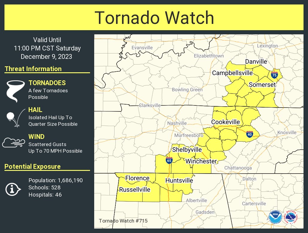
New tornado watch, just east of the current watch.
Posted on 12/9/23 at 3:23 pm to Roll Tide Ravens
Yeah, my phone just went off for the new watch.
Posted on 12/9/23 at 3:26 pm to Roll Tide Ravens
Starting to see those pre-frontal confluence bands fire heading into north AL. It is a little earlier than expected. Hopefully, that throws off the timing with when the LLJ kicks in later.
Posted on 12/9/23 at 3:27 pm to LegendInMyMind
Noticing some discreet showers/storms developing across central and south MS. Gonna have to watch those as they move northeast.
Posted on 12/9/23 at 3:27 pm to Roll Tide Ravens
Tornado hit near Ft. Campbell. Can confirm firsthand drive through the debris field not long after. Crossed I24.
Posted on 12/9/23 at 3:47 pm to LegendInMyMind
quote:I prefer country and western bands...
those pre-frontal confluence bands
Posted on 12/9/23 at 3:52 pm to Roll Tide Ravens
quote:
Noticing some discreet showers/storms developing across central and south MS. Gonna have to watch those as they move northeast.
Posted on 12/9/23 at 3:57 pm to Mid Iowa Tiger
All the warnings here. Stuff is north and west of us for now, but we'll see how that lines acts as it moves. I heard 2 confirmed touch downs (Dickson and Ft Campbell areas) on the radio just now.
Posted on 12/9/23 at 4:02 pm to Roll Tide Ravens
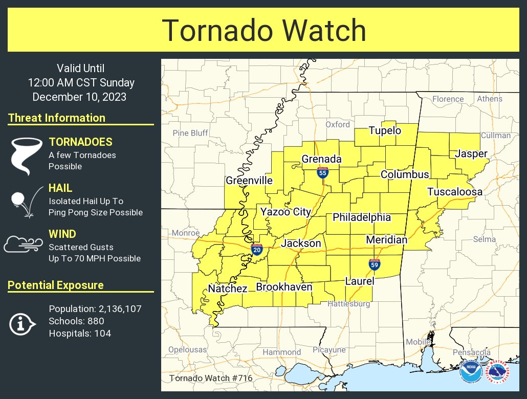
New tornado watch:
Posted on 12/9/23 at 4:04 pm to Roll Tide Ravens
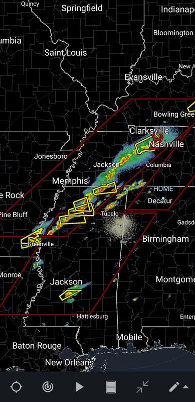
Close to having a tornado between Ashland and Falkner, MS.
ETA: immediately following this post the warning was issued.
ETA: immediately following this post the warning was issued.
This post was edited on 12/9/23 at 4:05 pm
Posted on 12/9/23 at 4:06 pm to LegendInMyMind
This storm just west of Nashville has a tight circulation.
Posted on 12/9/23 at 4:07 pm to Roll Tide Ravens

Posted on 12/9/23 at 4:08 pm to LegendInMyMind
Weird drawing and disjointed issuance has left some counties out of the Tornado Watch that should probably be included:
This post was edited on 12/9/23 at 4:08 pm

 Page 4 of 14

Popular
Back to top