- My Forums
- Tiger Rant
- LSU Recruiting
- SEC Rant
- Saints Talk
- Pelicans Talk
- More Sports Board
- Fantasy Sports
- Golf Board
- Soccer Board
- O-T Lounge
- Tech Board
- Home/Garden Board
- Outdoor Board
- Health/Fitness Board
- Movie/TV Board
- Book Board
- Music Board
- Political Talk
- Money Talk
- Fark Board
- Gaming Board
- Travel Board
- Food/Drink Board
- Ticket Exchange
- TD Help Board
Customize My Forums- View All Forums
- Show Left Links
- Topic Sort Options
- Trending Topics
- Recent Topics
- Active Topics
Started By
Message

 1
1

Posted on 12/28/24 at 2:35 pm to Roll Tide Ravens
Yep as the afternoon goes on the PDS watch will move east
Posted on 12/28/24 at 2:56 pm to SWLA92
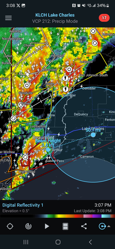
The bay tornado is still rolling. It has a gate to gate of 187.9. Stout arse couplet.
Posted on 12/28/24 at 2:56 pm to Roll Tide Ravens
Tornado warned storms entering the ArkLaMiss radar hole.
Posted on 12/28/24 at 2:58 pm to Roll Tide Ravens

Posted on 12/28/24 at 2:59 pm to LegendInMyMind
You'd think with the showers we are having this afternoon here in Central Alabama that would tamp down severity levels later tonight
Posted on 12/28/24 at 3:00 pm to LegendInMyMind
That storm has triggered a PDS tornado warning heading towards Port Arthur. Very well could be a strong EF3+ tornado
This post was edited on 12/28/24 at 3:02 pm
Posted on 12/28/24 at 3:02 pm to LegendInMyMind
Port Arthur included in the new PDS warning for the bay tornado.
This post was edited on 12/28/24 at 3:03 pm
Posted on 12/28/24 at 3:03 pm to East Coast Band
quote:
You'd think with the showers we are having this afternoon here in Central Alabama that would tamp down severity levels later tonight
I think it may. It definitely doesn't hurt.
Posted on 12/28/24 at 3:03 pm to SWLA92
BULLETIN - EAS ACTIVATION REQUESTED
Tornado Warning
National Weather Service Lake Charles LA
258 PM CST Sat Dec 28 2024
The National Weather Service in Lake Charles has issued a
* Tornado Warning for...
Jefferson County in southeastern Texas...
* Until 345 PM CST.
* At 257 PM CST, a large and extremely dangerous tornado was located
near Stowell, or 12 miles southwest of Hamshire, moving east at 50
mph.
This is a PARTICULARLY DANGEROUS SITUATION. TAKE COVER NOW!
HAZARD...Damaging tornado.
SOURCE...Radar indicated rotation.

Posted on 12/28/24 at 3:09 pm to Roll Tide Ravens
About and hour out from lake charles. Heads up!
Posted on 12/28/24 at 3:09 pm to LegendInMyMind
You can see a weaker return on Reflectivity where precip has cleared from the "eye" of the tornado.

Posted on 12/28/24 at 3:12 pm to LSURoss
That one has the look of a long tracker.
Posted on 12/28/24 at 3:12 pm to LSURoss
This tornado/storm has been nearly steady state for well over an hour now. It hasn't really cycled at all.
Posted on 12/28/24 at 3:16 pm to LSURoss
All the tornadoes in Texas, is that from the line that will be in Baton Rouge tonight ? Will it still be as strong ?
Posted on 12/28/24 at 3:18 pm to LegendInMyMind
NWS Lake Charles took over on the storm and now has a PDS warning for Port Arthur and LaBelle.
quote:
At 308 PM CST, a confirmed large and extremely dangerous tornado was
located near Stowell, or 11 miles south of Hamshire, moving northeast
at 30 mph.
This is a PARTICULARLY DANGEROUS SITUATION. TAKE COVER NOW!
HAZARD...Damaging tornado.
SOURCE...Radar confirmed tornado.
IMPACT...You are in a life-threatening situation. Flying debris may
be deadly to those caught without shelter. Mobile homes
will be destroyed. Considerable damage to homes,
businesses, and vehicles is likely and complete destruction
is possible.
The tornado will be near...
La Belle around 330 PM CST.
Port Arthur around 340 PM CST.
Other locations impacted by this tornadic thunderstorm include Sea
Rim State Park.
Posted on 12/28/24 at 3:19 pm to Old Man and a Porch
quote:
All the tornadoes in Texas, is that from the line that will be in Baton Rouge tonight ? Will it still be as strong ?
Yes, along with other storms ahead of or between lines. It very likely could be as strong.
Posted on 12/28/24 at 3:20 pm to G2160
Big tornado on the ground from SW of Alvin all the way to south of Winnie in southeast Texas-- considerable damage reported, but no reports yet of injuries
Posted on 12/28/24 at 3:22 pm to LegendInMyMind
Storms are lining out in East Texas. Hopefully, that line can overtake the front running supers.

 Page 7 of 26

Popular
Back to top