




- My Forums
- Tiger Rant
- LSU Recruiting
- SEC Rant
- Saints Talk
- Pelicans Talk
- More Sports Board
- Fantasy Sports
- Golf Board
- Soccer Board
- O-T Lounge
- Tech Board
- Home/Garden Board
- Outdoor Board
- Health/Fitness Board
- Movie/TV Board
- Book Board
- Music Board
- Political Talk
- Money Talk
- Fark Board
- Gaming Board
- Travel Board
- Food/Drink Board
- Ticket Exchange
- TD Help Board
Customize My Forums- View All Forums
- Show Left Links
- Topic Sort Options
- Trending Topics
- Recent Topics
- Active Topics
Started By
Message

Significant Severe Weather Outbreak Saturday (Iowa/Illinois)
Posted on 3/27/20 at 10:29 pm


Posted on 3/27/20 at 10:29 pm
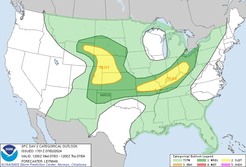
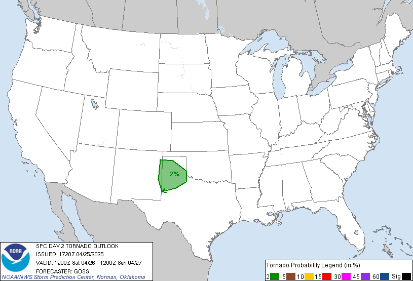
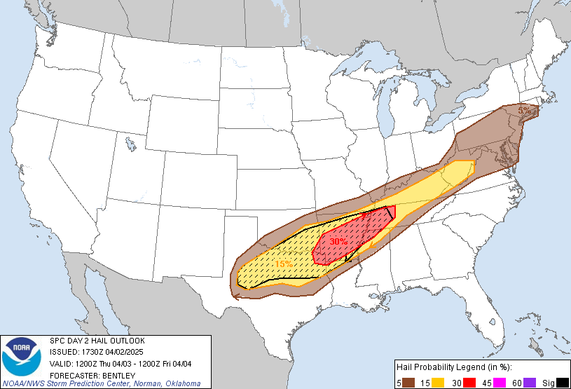
quote:
...SUMMARY... A significant severe weather outbreak is possible for portions of the middle Mississippi Valley on Saturday. The threats with the stronger storms include tornadoes, a few which may be significant, large to very large hail, and severe gusts.
 6
6


Posted on 3/27/20 at 10:33 pm to GEAUXmedic
That’s only one step down from “Hide the women and children!” Quad Cities might be down to two or three.
Posted on 3/27/20 at 10:44 pm to RockChalkTiger
Happy Tornado Season, everyone

Posted on 3/27/20 at 10:48 pm to GEAUXmedic
In all seriousness, will it get into central MS and make me have to go to work? Or will it get bad in north MS and I have to travel. Look into your crystal ball and tell me friend!

Posted on 3/27/20 at 10:50 pm to GEAUXmedic
Is it crazy that I am actually happy to see one of these threads instead of a covid one?

Posted on 3/27/20 at 10:51 pm to GEAUXmedic
I’m having a significant severe outbreak myself..
Posted on 3/27/20 at 10:58 pm to DavidTheGnome
quote:
I’m having a significant severe outbreak myself..
Eww...
Posted on 3/28/20 at 11:07 am to GEAUXmedic
SPC Update

It looks like some early day convection might prevent this event from reaching some of the higher end solutions that have been tossed around.
00z HRRR at 18z Today showing a pretty clean target area allowing for the parameter space to really ramp up heading towards 00z.

15z HRRR at 18z today showing multiple showers and storms ongoing across the target area. That could keep things in check but maybe some time for recovery in the SW portions of the MOD risk area.

It looks like some early day convection might prevent this event from reaching some of the higher end solutions that have been tossed around.
00z HRRR at 18z Today showing a pretty clean target area allowing for the parameter space to really ramp up heading towards 00z.
15z HRRR at 18z today showing multiple showers and storms ongoing across the target area. That could keep things in check but maybe some time for recovery in the SW portions of the MOD risk area.
Posted on 3/28/20 at 11:17 am to rds dc
Unrelated to today's event but the SPC has highlighted parts of LA and E. TX for Monday

Posted on 3/28/20 at 11:20 am to rds dc
quote:
Unrelated to today's event but the SPC has highlighted parts of LA and E. TX for Monday
yay... I get to weather watch on Monday

Posted on 3/28/20 at 2:43 pm to rt3
potential PDS Tornado Watch about to come out

Posted on 3/28/20 at 3:25 pm to rt3
we do in fact have a PDS Tornado Watch issued
quote:
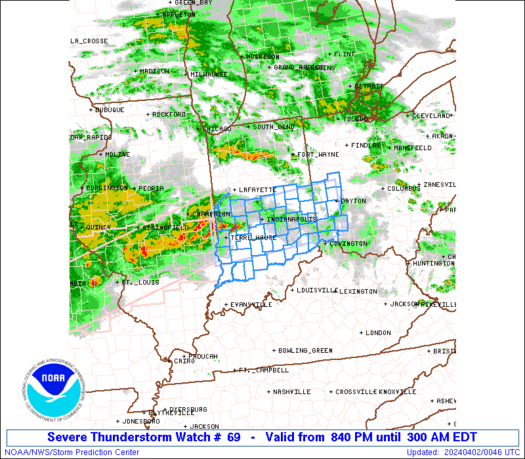
URGENT - IMMEDIATE BROADCAST REQUESTED
Tornado Watch Number 69
NWS Storm Prediction Center Norman OK
240 PM CDT Sat Mar 28 2020
The NWS Storm Prediction Center has issued a
* Tornado Watch for portions of
parts of central and eastern Iowa
portions of central and northern Illinois
northeastern Missouri
* Effective this Saturday afternoon and evening from 240 PM until
900 PM CDT.
...THIS IS A PARTICULARLY DANGEROUS SITUATION...
* Primary threats include...
Several tornadoes and a few intense tornadoes likely
Scattered large hail and isolated very large hail events to 2.5
inches in diameter likely
Scattered damaging wind gusts to 70 mph possible
SUMMARY...Thunderstorms are forecast to gradually increase in both
coverage and intensity over the next few hours, with several intense
supercell storms expected to evolve. Along with risk for damaging
winds and very large hail, several tornadoes -- including the
potential for a few being significant/long-track -- can be expected.
The tornado watch area is approximately along and 110 statute miles
either side of a line from 35 miles north northwest of Cedar Rapids
IA to 70 miles south southeast of Quincy IL. For a complete
depiction of the watch see the associated watch outline update
(WOUS64 KWNS WOU9).
PRECAUTIONARY/PREPAREDNESS ACTIONS...
REMEMBER...A Tornado Watch means conditions are favorable for
tornadoes and severe thunderstorms in and close to the watch
area. Persons in these areas should be on the lookout for
threatening weather conditions and listen for later statements
and possible warnings.
&&
OTHER WATCH INFORMATION...CONTINUE...WW 67...WW 68...
AVIATION...Tornadoes and a few severe thunderstorms with hail
surface and aloft to 2.5 inches. Extreme turbulence and surface wind
gusts to 60 knots. A few cumulonimbi with maximum tops to 500. Mean
storm motion vector 22040.
...Goss

Posted on 3/28/20 at 3:53 pm to rt3
Is there not also concern for Arkansa/MS/TN this evening? I see Arky is currently under a tornado watch
Posted on 3/28/20 at 5:06 pm to Wishnitwas1998
Arky DOT camera caught a tornado on the ground in Jonesboro... and that tornado is getting worse right now heading right for Brookland
Posted on 3/28/20 at 5:08 pm to rt3
That was nuts to see it come into the camera view and get larger.
Posted on 3/28/20 at 5:09 pm to lsuman25
quote:
That was nuts to see it come into the camera view and get larger.
a storm chaser couldn't have gotten a better view of that tornado
Posted on 3/28/20 at 5:13 pm to rt3
quote:
a storm chaser couldn't have gotten a better view of that tornado
It reminds me alot of the Cullman tornado on April 27. They had it coming toward the camera for quite a while until it took out the camera.
This post was edited on 3/28/20 at 5:15 pm

Posted on 3/28/20 at 5:19 pm to GEAUXmedic
The one on the ground just east of Jonesboro, Arkanasas looks insane.
This post was edited on 3/28/20 at 5:19 pm
Posted on 3/28/20 at 5:19 pm to LegendInMyMind
quote:
It reminds me alot of the Cullman tornado on April 27. They had it coming toward the camera for quite a while until it took out the camera.
I've watched all 8 hours of James Spann's coverage of the day of that super outbreak with the Cullman & Tuscaloosa tornadoes... the skycams were perfectly placed that day for those 2 twisters

 Page 1 of 3

Popular
Back to top
 Follow TigerDroppings for LSU Football News