- My Forums
- Tiger Rant
- LSU Recruiting
- SEC Rant
- Saints Talk
- Pelicans Talk
- More Sports Board
- Fantasy Sports
- Golf Board
- Soccer Board
- O-T Lounge
- Tech Board
- Home/Garden Board
- Outdoor Board
- Health/Fitness Board
- Movie/TV Board
- Book Board
- Music Board
- Political Talk
- Money Talk
- Fark Board
- Gaming Board
- Travel Board
- Food/Drink Board
- Ticket Exchange
- TD Help Board
Customize My Forums- View All Forums
- Show Left Links
- Topic Sort Options
- Trending Topics
- Recent Topics
- Active Topics
Started By
Message
re: Severe weather threat continues today for parts of the southeast - Threat is Over.
Posted on 3/16/21 at 12:03 pm to LegendInMyMind
Posted on 3/16/21 at 12:03 pm to LegendInMyMind
quote:
quote:
He is saying there may be severe storms in the southeast Tonight?. I don’t understand
It is possible in the early morning hours in those areas, yes. It is more him saying that the overnight threat is there for tonight, and if storms do develop they could go severe fairly easily and catch people off guard.
The Slight along I20 in N. Louisiana and up into Ark & Miss is mainly for overnight storms that, if discrete in nature, could pose a tornado threat.

 3
3


Posted on 3/16/21 at 12:18 pm to rds dc
GA, SC, and NC baws in the red on Thursday night. OP should probably add these to OP as well.

Posted on 3/16/21 at 12:20 pm to rds dc
quote:
Based on 12z guidance, maybe a south shift of the MOD or an expansion of the MOD SW into NE LA. Don't think anything in the 12z guidance justifies an upgrade.
I would almost bet that the Moderate area will be expanded Southwest. There's little reason not to at this point. I don't think they will bump anywhere to High right now. I imagine the SPC is content to leave the Moderate and do area-based threat guidance as storms unfold. It makes sense with the nature of this setup.
This post was edited on 3/16/21 at 12:23 pm
Posted on 3/16/21 at 12:21 pm to Duckhammer_77
quote:
Awesome. The one day I have to drive BR to morgan city then lafayette for work.
Dude you might want to think about Easter Sunday last year and leave today.
Posted on 3/16/21 at 12:22 pm to deeprig9
quote:
GA, SC, and NC baws in the red on Thursday night. OP should probably add these to OP as well.
Yep. Looks to be mostly a QLCS threat for them. It will be the best/highest severe/tornado threat they've seen in quite a while.

Posted on 3/16/21 at 12:24 pm to deeprig9
quote:
GA, SC, and NC baws in the red on Thursday night.
Thanks, baw. Now I know to stock up on beer and liquor.

Posted on 3/16/21 at 12:30 pm to deeprig9
I added the Convective outlook for Thursday to the OP and updated the thread title.
Posted on 3/16/21 at 12:31 pm to LegendInMyMind
About that chaser dilemma I mentioned earlier in the thread. They are, as expected, lining up to chase the Deep South. Chasing discreet, or semi-discreet, storms down here is one thing. Chasing a line of storms that has a risk of strong, embedded tornadoes in this terrain is an entirely different prospect. They better choose wisely where they set up, and do some considerable research on the roads in the area. If we end up with cells out front of a legit tornado-producing QLCS they could get into a mess in a hurry.
This isn't one for a novice chaser to dick around with. Though, for you baws who love watching weather drama, it could be gold.
This isn't one for a novice chaser to dick around with. Though, for you baws who love watching weather drama, it could be gold.

Posted on 3/16/21 at 12:37 pm to LegendInMyMind
Getting windy in Br
Posted on 3/16/21 at 12:38 pm to rds dc
quote:
Based on 12z guidance, maybe a south shift of the MOD or an expansion of the MOD SW into NE LA. Don't think anything in the 12z guidance justifies an upgrade.

Posted on 3/16/21 at 12:40 pm to LegendInMyMind
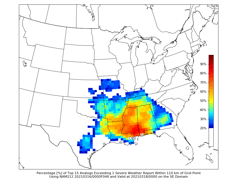
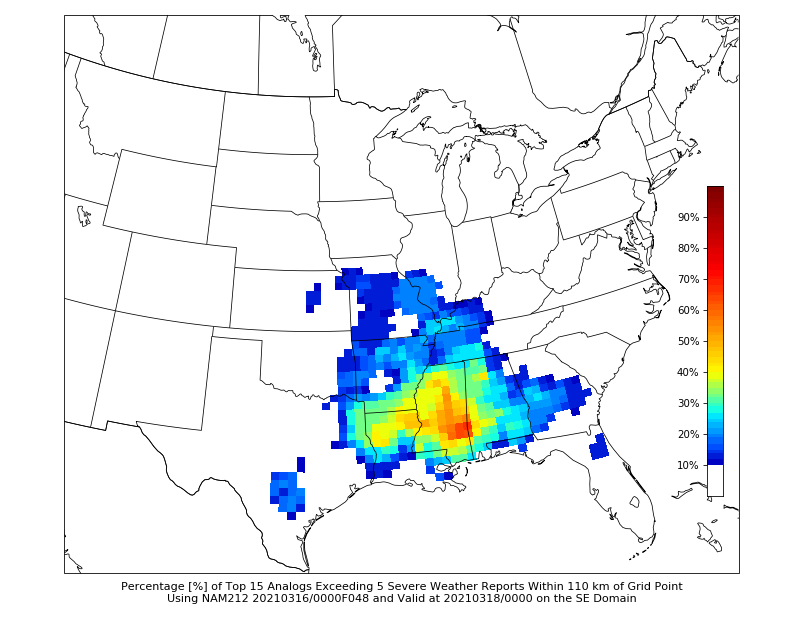
Latest CIPS Analog guidance for severe reports across the area. It is hinting at Southern MS, as well. It will be interesting to see how the Historic Analogs do with this event, as it doesn't have an ideal analog to draw on.

Posted on 3/16/21 at 12:41 pm to rds dc
So I live in GA just east of where the first map's enhanced zone ends and just west of where the second map's enhanced zone begins. Lucky me... 
Posted on 3/16/21 at 12:42 pm to LegendInMyMind
New Day 2 Convective outlook. Moderate risk has been expanded southwest.

Tornado probabilities:

Tornado probabilities:
Posted on 3/16/21 at 12:42 pm to SM6
quote:
So I live in GA just east of where the first map's enhanced zone ends and just west of where the second map's enhanced zone begins. Lucky me...
That just means you jumped time, baw. You're between the timeframes of both outlooks. It could go either way for you.
Posted on 3/16/21 at 12:43 pm to Roll Tide Ravens
This is one of the biggest moderate risks I can recall seeing in the southeast in a while.
Posted on 3/16/21 at 12:43 pm to Roll Tide Ravens
quote:
Moderate risk has been expanded southwest.
Makes damn good sense. That SW MS area looks primed right now.
Posted on 3/16/21 at 12:44 pm to Roll Tide Ravens
quote:
This is one of the biggest moderate risks I can recall seeing in the southeast in a while.
Definitely a nod to the complex setup.
Posted on 3/16/21 at 12:51 pm to LegendInMyMind
Even the "badass" who started the Twitter shitshow a few days ago has changed his tune about where he will chase:
This is the same guy who said just yesterday that his "favorite terrain to chase" is Southern AL.
quote:
Gonna try to give the MS Delta a shot tomorrow. Originally wanted to position further east but want to give the better terrain a shot given its position on the western edge of the LLJ maxima and signs of clearing in E AR from latest HRRR and WRFs. It's trial and error every time.
This is the same guy who said just yesterday that his "favorite terrain to chase" is Southern AL.
Posted on 3/16/21 at 12:55 pm to Roll Tide Ravens
quote:
New Day 2 Convective outlook
quote:
If these trends are maintained, an upgrade to a High risk
could be necessary with the initial Day 1 Convective Outlook at 06z
tonight.

Posted on 3/16/21 at 12:55 pm to LegendInMyMind
It's the largest MOD since they started issuing MODs in 2014.

 Page 9 of 64

Popular
Back to top