- My Forums
- Tiger Rant
- LSU Recruiting
- SEC Rant
- Saints Talk
- Pelicans Talk
- More Sports Board
- Coaching Changes
- Fantasy Sports
- Golf Board
- Soccer Board
- O-T Lounge
- Tech Board
- Home/Garden Board
- Outdoor Board
- Health/Fitness Board
- Movie/TV Board
- Book Board
- Music Board
- Political Talk
- Money Talk
- Fark Board
- Gaming Board
- Travel Board
- Food/Drink Board
- Ticket Exchange
- TD Help Board
Customize My Forums- View All Forums
- Show Left Links
- Topic Sort Options
- Trending Topics
- Recent Topics
- Active Topics
Started By
Message
re: Severe weather threat continues today for parts of the southeast - Threat is Over.
Posted on 3/17/21 at 4:53 pm to East Coast Band

Posted on 3/17/21 at 4:53 pm to East Coast Band
Drone footage of tornado from Silas
https://mobile.twitter.com/brianemfinger/status/1372302378758770690
https://mobile.twitter.com/brianemfinger/status/1372302378758770690
 2
2

Posted on 3/17/21 at 4:55 pm to LegendInMyMind
Sorry no luck
Posted on 3/17/21 at 4:55 pm to Bobby OG Johnson
Nevermind
This post was edited on 3/17/21 at 4:56 pm
Posted on 3/17/21 at 4:57 pm to LegendInMyMind
Posted on 3/17/21 at 4:57 pm to red sox fan 13
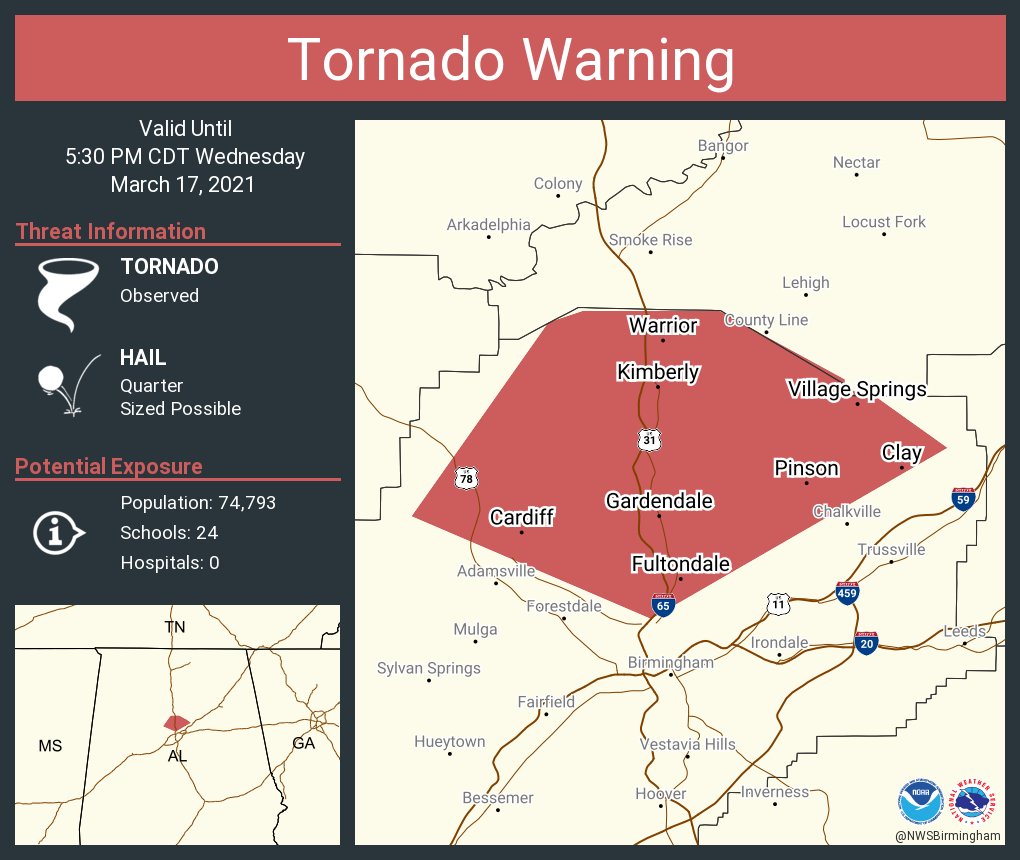
Severe Weather Statement
National Weather Service Birmingham AL
455 PM CDT Wed Mar 17 2021
ALC073-172230-
/O.CON.KBMX.TO.W.0028.000000T0000Z-210317T2230Z/
Jefferson AL-
455 PM CDT Wed Mar 17 2021
...A TORNADO WARNING REMAINS IN EFFECT UNTIL 530 PM CDT FOR
NORTHEASTERN JEFFERSON COUNTY...
At 454 PM CDT, a confirmed tornado was located over Brookside, or
near Gardendale, moving northeast at 25 mph.
HAZARD...Damaging tornado and quarter size hail.
SOURCE...Radar confirmed tornado.
IMPACT...Flying debris will be dangerous to those caught without
shelter. Mobile homes will be damaged or destroyed. Damage
to roofs, windows, and vehicles will occur. Tree damage is
likely.
Locations impacted include...
Northern Birmingham, Gardendale, Fultondale, Center Point, Clay,
Pinson, Tarrant, Adamsville, Warrior, Kimberly, Graysville, Morris,
Brookside, Trafford, County Line, Cardiff, Chalkville, Sayre,
Palmerdale and Village Springs.
PRECAUTIONARY/PREPAREDNESS ACTIONS...
To repeat, a tornado is on the ground. TAKE COVER NOW! Move to a
basement or an interior room on the lowest floor of a sturdy
building. Avoid windows. If you are outdoors, in a mobile home, or in
a vehicle, move to the closest substantial shelter and protect
yourself from flying debris.

Posted on 3/17/21 at 4:58 pm to LegendInMyMind
I don’t understand why the Mount Olive MS cell is not warned. They are about to get clapped.
Posted on 3/17/21 at 5:00 pm to 50_Tiger
quote:
I don’t understand why the Mount Olive MS cell is not warned. They are about to get clapped.
Damn sure looks like it should be.

Posted on 3/17/21 at 5:03 pm to Bobby OG Johnson
quote:
My coworker lives in the red. We all went home early. He should've stayed at the office...
Posted on 3/17/21 at 5:05 pm to Funky Tide 8
Posted on 3/17/21 at 5:05 pm to LegendInMyMind
Talk about boundaries. It was 82 degrees in Tupelo, MS and 61 in Madison, AL about an hour ago. For me, with the South wind, it is jacket weather. Such a weird setup.
Posted on 3/17/21 at 5:05 pm to LegendInMyMind
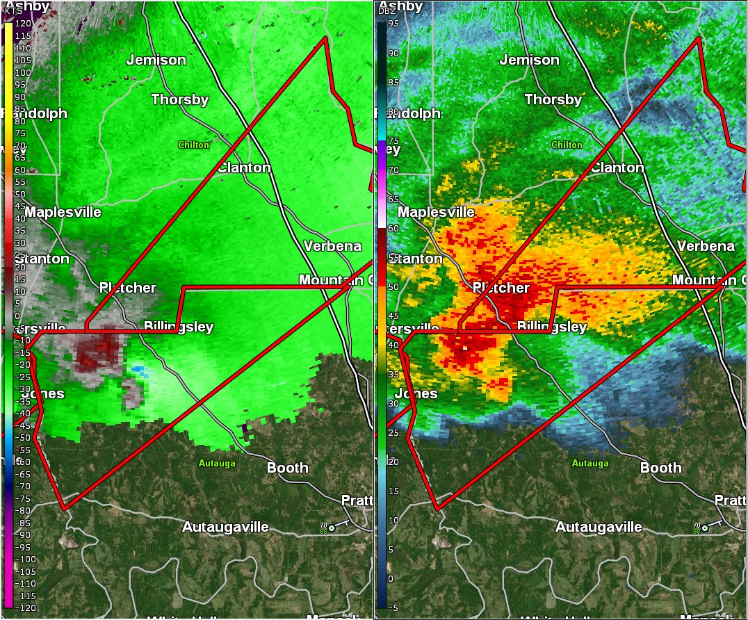
I wonder if anything was on the ground as the velo couplet went directly over town
Posted on 3/17/21 at 5:07 pm to 50_Tiger
Posted on 3/17/21 at 5:08 pm to 50_Tiger
quote:
I wonder if anything was on the ground as the velo couplet went directly over town
I don't know. It got a TVS tag shortly after you mentioned it. CC didn't show much.
Posted on 3/17/21 at 5:08 pm to NorthEndZone
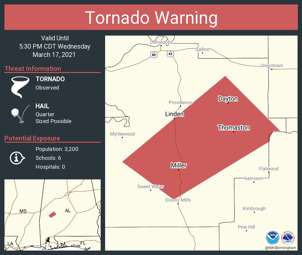
Severe Weather Statement
National Weather Service Birmingham AL
503 PM CDT Wed Mar 17 2021
ALC091-172230-
/O.CON.KBMX.TO.W.0027.000000T0000Z-210317T2230Z/
Marengo AL-
503 PM CDT Wed Mar 17 2021
...A TORNADO WARNING REMAINS IN EFFECT UNTIL 530 PM CDT FOR CENTRAL
MARENGO COUNTY...
At 503 PM CDT, a confirmed tornado was located over Miller, or 10
miles south of Linden, moving northeast at 40 mph.
HAZARD...Damaging tornado and quarter size hail.
SOURCE...Weather spotters confirmed tornado.
IMPACT...Flying debris will be dangerous to those caught without
shelter. Mobile homes will be damaged or destroyed. Damage
to roofs, windows, and vehicles will occur. Tree damage is
likely.
Locations impacted include...
Linden, Thomaston, Sweet Water, Dayton, Wayne, Freddie Jones Field,
Miller, Consul, Calvary, Half Acre and Octagon.
Posted on 3/17/21 at 5:12 pm to Wishnitwas1998
Just getting done with work, I'm in Santa Rosa County in Florida. Did these storms shift north or still expecting bad weather from it?

Posted on 3/17/21 at 5:13 pm to NorthEndZone
Was just listening to police scanner in parts of Alabama and parts got hit pretty bad. We have a bad one headed our way ( Just outside Jackson, Ms and that will eventually be going into Alabama also.
Posted on 3/17/21 at 5:17 pm to NorthEndZone
Just getting a little rain here. Not even any wind or thunder and the front is here.
Posted on 3/17/21 at 5:18 pm to deltaland
So radar makes it look like Nola is going to get it pretty bad in the next couple hours.
Posted on 3/17/21 at 5:22 pm to NorthEndZone
Severe Weather Statement
National Weather Service Birmingham AL
518 PM CDT Wed Mar 17 2021
ALC073-172230-
/O.CON.KBMX.TO.W.0028.000000T0000Z-210317T2230Z/
Jefferson AL-
518 PM CDT Wed Mar 17 2021
...A TORNADO WARNING REMAINS IN EFFECT UNTIL 530 PM CDT FOR
NORTHEASTERN JEFFERSON COUNTY...
At 518 PM CDT, a confirmed tornado was located over Morris, or near
Gardendale, moving northeast at 25 mph.
HAZARD...Damaging tornado and quarter size hail.
SOURCE...Public confirmed tornado.
IMPACT...Flying debris will be dangerous to those caught without
shelter. Mobile homes will be damaged or destroyed. Damage
to roofs, windows, and vehicles will occur. Tree damage is
likely.
Locations impacted include...
Warrior, Kimberly, Morris, Trafford and County Line.

 Page 53 of 64

Popular
Back to top