- My Forums
- Tiger Rant
- LSU Recruiting
- SEC Rant
- Saints Talk
- Pelicans Talk
- More Sports Board
- Fantasy Sports
- Golf Board
- Soccer Board
- O-T Lounge
- Tech Board
- Home/Garden Board
- Outdoor Board
- Health/Fitness Board
- Movie/TV Board
- Book Board
- Music Board
- Political Talk
- Money Talk
- Fark Board
- Gaming Board
- Travel Board
- Food/Drink Board
- Ticket Exchange
- TD Help Board
Customize My Forums- View All Forums
- Show Left Links
- Topic Sort Options
- Trending Topics
- Recent Topics
- Active Topics
Started By
Message
re: Severe weather threat continues today for parts of the southeast - Threat is Over.
Posted on 3/15/21 at 3:45 pm to Roll Tide Ravens

Posted on 3/15/21 at 3:45 pm to Roll Tide Ravens
He's probably loosening the suspenders as we speak.
 1
1


Posted on 3/15/21 at 3:47 pm to HempHead
They’re definitely sounding all of the alarm bells now.
Posted on 3/15/21 at 3:47 pm to Roll Tide Ravens
so what’s the timing on this? what time during the day on Wendesday?
Posted on 3/15/21 at 3:47 pm to Roll Tide Ravens
Looks like there is already some activity hovering over JeffCo and Shelby right now.
Posted on 3/15/21 at 3:50 pm to HempHead
Hemp! What's up brother! You back in North Alabama?
Posted on 3/15/21 at 3:51 pm to HoLeInOnEr05
Back and forth between God's country and Birmingham. 
Posted on 3/15/21 at 3:52 pm to East Coast Band
It’s stupid for enhanced risk to be milder than moderate risk. Should be other way around, enhanced sounds worse than moderate
Posted on 3/15/21 at 3:53 pm to East Coast Band
Eastern MS and West Alabama will get the worst of it as they storms will roll through during the hot part of the day
Posted on 3/15/21 at 3:55 pm to East Coast Band
quote:
thought the 30% was something along the lines of reasoning that there is a 30% chance of a severe weather event, thunderstorm or tornado, that will occur within so many miles of any particular location.
It is. Mostly because severe supercells are isolated events so you could have a tornado outbreak all over your state but not get within 50 miles of a severe storm.
Posted on 3/15/21 at 3:57 pm to tgrbaitn08
quote:
But PeeJ said.... nothing to worry about
Wanna make something of it PUNK,,,,,,,,?
Posted on 3/15/21 at 4:01 pm to Roll Tide Ravens
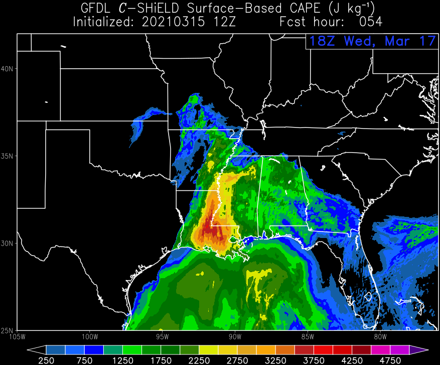
Interesting latest run on CAPE. I didn't expect to see those values so far south. I expected that more over Central MS/AL.

Posted on 3/15/21 at 4:02 pm to Bestbank Tiger
When did I say this????
Posted on 3/15/21 at 4:05 pm to LegendInMyMind
What do the numbers on the bottom mean?

Posted on 3/15/21 at 4:05 pm to deltaland
quote:
It’s stupid for enhanced risk to be milder than moderate risk. Should be other way around, enhanced sounds worse than moderate
They're guarding against AI and computers fully taking over
They have to be around to explain why slight actually means "kind of bad", enhanced is "pretty bad" and "moderate" means "you might be legit fricked"
Posted on 3/15/21 at 4:05 pm to LegendInMyMind
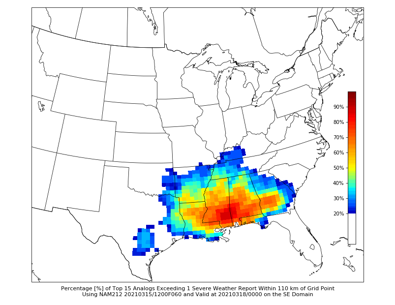
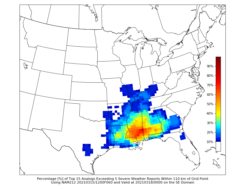
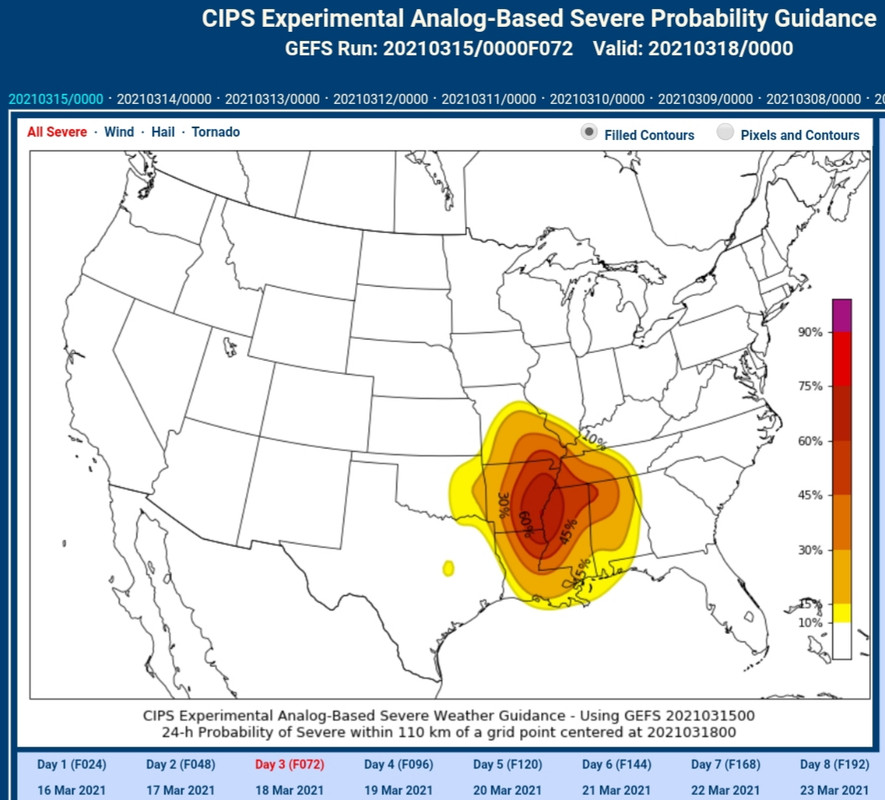
CIPS Analog Threat Guidance has shifted it a bit further to the South, too.
Posted on 3/15/21 at 4:05 pm to Roll Tide Ravens
quote:
The STP on their radar system provided the STP for specific storms. It was supposed to be a 0-10 scale. When the first severe storm of that afternoon popped over Walker County, AL (this would ultimately produce the Cullman EF-4 tornado), they looked at the STP on the storm (which wasn’t even tornado warned yet), and it was 12.6. They were blown away.
The storms produced by that outbreak were something.
Here is a pic of all the warnings from that system

Posted on 3/15/21 at 4:07 pm to Bestbank Tiger
quote:
What do the numbers on the bottom mean?
CAPE is essentially a measure of potential energy available in the atmosphere for a storm. The higher number/brighter the color, the more available potential energy you have for storms to draw on.
Posted on 3/15/21 at 4:11 pm to LegendInMyMind
Similar placement on the CIPS analog severe probability map.
Posted on 3/15/21 at 4:17 pm to LegendInMyMind
Their afternoon forecast discussion is a bit too complicated for posting here, but the National Weather Service in Birmingham discussed the possibility for three rounds of severe weather across Alabama on Wednesday: storms that form along a northward moving warm front Wednesday morning, discrete cells that form during the midday and afternoon, and then the storms ahead of the actual cold front.
Posted on 3/15/21 at 4:20 pm to Pettifogger
quote:
They're guarding against AI and computers fully taking over
It’s really more of a matter of the fact that the categories of slight, moderate and high already existed and then they added marginal and enhanced but didn’t want to create confusion by removing or changing the other categories. You have to remember, many people can’t even point to their location on a map, so if you change the categories they’re used to, they will be lost.

 Page 4 of 64

Popular
Back to top