- My Forums
- Tiger Rant
- LSU Recruiting
- SEC Rant
- Saints Talk
- Pelicans Talk
- More Sports Board
- Fantasy Sports
- Golf Board
- Soccer Board
- O-T Lounge
- Tech Board
- Home/Garden Board
- Outdoor Board
- Health/Fitness Board
- Movie/TV Board
- Book Board
- Music Board
- Political Talk
- Money Talk
- Fark Board
- Gaming Board
- Travel Board
- Food/Drink Board
- Ticket Exchange
- TD Help Board
Customize My Forums- View All Forums
- Show Left Links
- Topic Sort Options
- Trending Topics
- Recent Topics
- Active Topics
Started By
Message
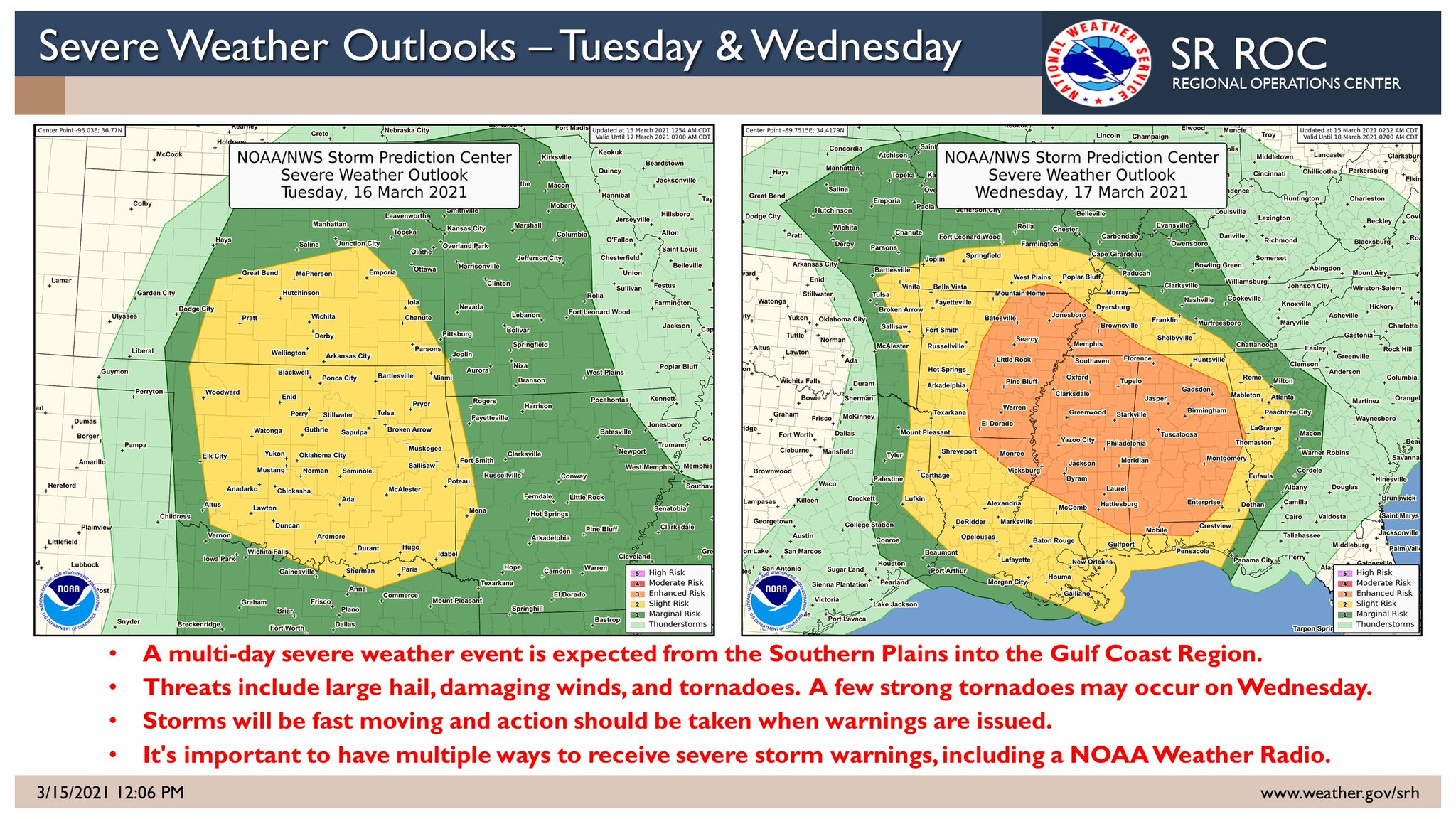
re: Severe weather threat continues today for parts of the southeast - Threat is Over.
Posted on 3/15/21 at 12:03 pm to East Coast Band

Posted on 3/15/21 at 12:03 pm to East Coast Band
quote:
I assume those numbers embedded are not good for you if it's a "7"
Nope, not good. Typically any number on the STP that is over 1 or 2 is pretty significant. 6s and 7s are bad news.
 1
1

Posted on 3/15/21 at 12:04 pm to Roll Tide Ravens
Always amazing to me how much worse Alabama and Mississippi get smoked by weather that just essentially dies as it crosses the Georgia line.
Posted on 3/15/21 at 12:04 pm to East Coast Band
quote:
I assume those numbers embedded are not good for you if it's a "7"
I remember back on April 27 Spann and Jason Simpson didn't know exactly STP topped out at. It was a relatively new product that they hadn't used much. They really were learning some stuff on the fly that day.
Posted on 3/15/21 at 12:07 pm to LegendInMyMind
quote:
I remember back on April 27 Spann and Jason Simpson didn't know exactly STP topped out at. It was a relatively new product that they hadn't used much. They really were learning some stuff on the fly that day.
The STP on their radar system provided the STP for specific storms. It was supposed to be a 0-10 scale. When the first severe storm of that afternoon popped over Walker County, AL (this would ultimately produce the Cullman EF-4 tornado), they looked at the STP on the storm (which wasn’t even tornado warned yet), and it was 12.6. They were blown away.
Posted on 3/15/21 at 12:10 pm to Roll Tide Ravens
This is the worst looking CAPE yet for Wednesday. Not off of the charts as we've seen in the past, but plenty enough energy to go around. It almost follows the contour of the SPC Enhanched area.
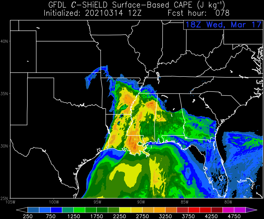
This post was edited on 3/15/21 at 12:16 pm
Posted on 3/15/21 at 12:12 pm to NorthGwinnettTiger
quote:
Always amazing to me how much worse Alabama and Mississippi get smoked by weather that just essentially dies as it crosses the Georgia line
It is definitely an interesting phenomenon.
And for those doubting this, it is absolutely true. We still get our tornadoes and severe storms here in Georgia but not near the volume that AL & MS get. It's like the air is more stable as soon as you cross into Georgia.

Posted on 3/15/21 at 12:14 pm to Lsuhoohoo
quote:
I'm no weather expert but it seems like this stretch of Southeastern states has really ramped up in activity to rival or even surpass Tornado alley as the more notorious tornado belt.
A study back in 2018 did indeed show that it seems 'tornado alley' has shifted more eastward.
Posted on 3/15/21 at 12:15 pm to SM6
quote:
I've been in west central Georgia for a few years now and always follow severe weather events in the area. It seems like without fail, they largely dissipate by the time they reach the Georgia/Alabama border. I know Georgia will occasionally get hit, but it seems like Alabama always gets slammed then it quickly calms down.
Is there some reason for that, or am I just imagining things?
Nope. You are correct.
I am also in west central Georgia. Griffin. Where are you located at?
Posted on 3/15/21 at 12:16 pm to LegendInMyMind
But PeeJ said.... nothing to worry about
Posted on 3/15/21 at 12:21 pm to Roll Tide Ravens
This Composite Reflectivity for earlier in the day Wednesday
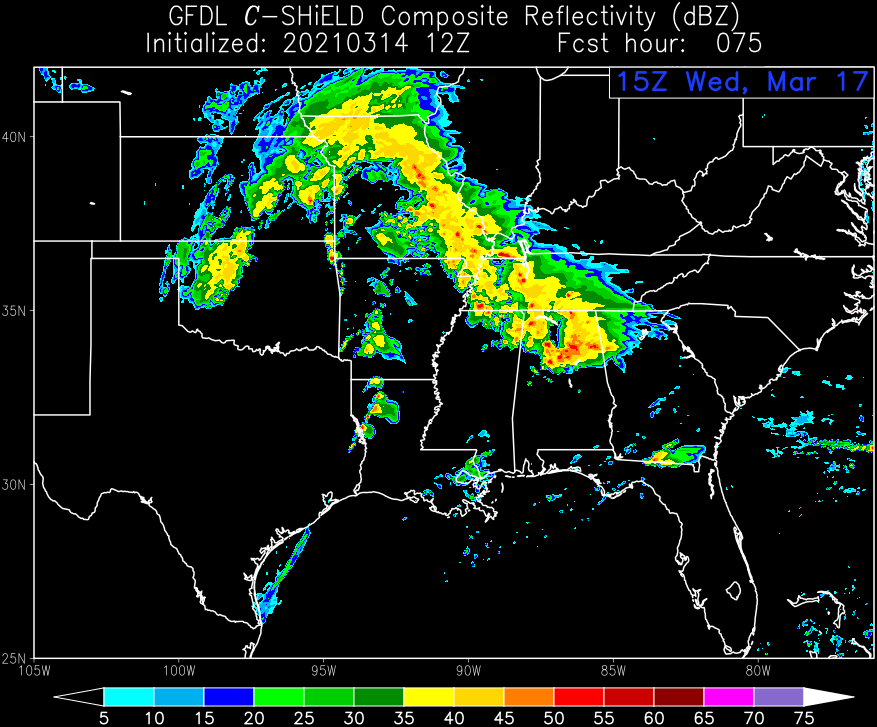
may help with this later in the day/evening.
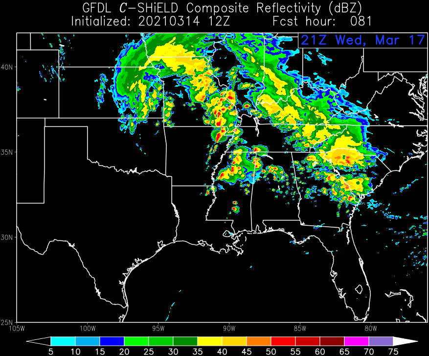
Hopefully that first round can suck up some of the energy, because I don't like those cells out in front of that second round.
may help with this later in the day/evening.
Hopefully that first round can suck up some of the energy, because I don't like those cells out in front of that second round.
Posted on 3/15/21 at 12:22 pm to tgrbaitn08
quote:
But PeeJ said.... nothing to worry about
This is why we can't have nice things....

Posted on 3/15/21 at 12:23 pm to SteelerBravesDawg
quote:
Griffin. Where are you located at?
I’m in Fayette just about 30 minutes west of you.
This post was edited on 3/15/21 at 12:51 pm
Posted on 3/15/21 at 12:24 pm to SM6
quote:
I’m in Fayette just about 30 minutes west of you.
Neighbor BINGO!
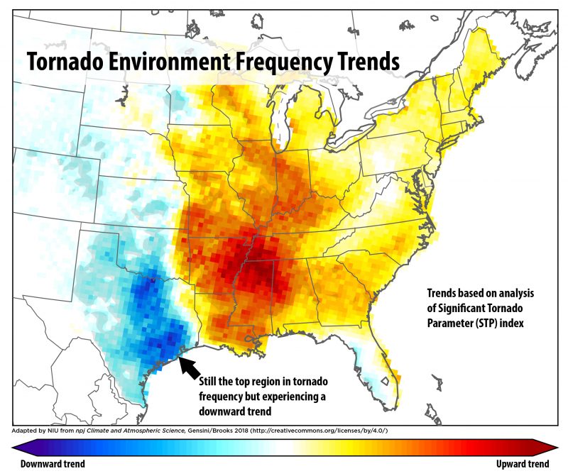
Posted on 3/15/21 at 12:51 pm to LegendInMyMind
This is a good info graphic for this event:
This post was edited on 3/15/21 at 12:52 pm
Posted on 3/15/21 at 1:33 pm to SM6
quote:
I’m in Fayette just about 30 minutes west of you.
We shop/eat in F'Ville & PTC a lot. Twisted Taco is our favorite place. Along w/Mellow Mushroom on 74 in PTC and Maguire's in Senoia.
Our church is also in F'Ville. St.Gabe's.
We live in SW Spalding. 2.5 miles from the Pike line and 20 from F'Ville and PTC and 15 from Senoia.
This post was edited on 3/15/21 at 1:37 pm
Posted on 3/15/21 at 1:36 pm to LegendInMyMind
quote:
Neighbor BINGO!
Southside, also?

Posted on 3/15/21 at 1:37 pm to SteelerBravesDawg
quote:
Southside, also?
No, he's my neighbor and I claim that spot on the bingo board.
Posted on 3/15/21 at 3:00 pm to HempHead
quote:
No, he's my neighbor and I claim that spot on the bingo board
Cowetian?
Posted on 3/15/21 at 3:07 pm to SM6
Limestoner
Posted on 3/15/21 at 3:44 pm to HempHead
Spann is now referring to this threat Wednesday as a “major severe weather threat.”
This is what he said in his afternoon weather blog discussion:
This is what he said in his afternoon weather blog discussion:
quote:
MAJOR SEVERE WEATHER THREAT WEDNESDAY: Parameters are coming together for a potentially dangerous severe weather event for Alabama and Mississippi Wednesday afternoon and Wednesday night. The combination of a negative tilt upper trough with strong wind fields, unstable air, high storm relative helicity values, and a strong low level jet will bring the risk of severe storms to the state with large hail, damaging winds, and tornadoes. A few strong/violent tornadoes can’t be ruled out. SPC has most of Alabama in an “enhanced risk” (level 3/5) for Wednesday afternoon and Wednesday night… I would not be surprised if that is upgraded to a “moderate risk” (level 4/5) in the new outlook late tonight.
Thunderstorms could begin over West Alabama during the afternoon hours… but for much of the state the core severe weather comes Wednesday evening and Wednesday night… into the pre-dawn hours Thursday.
This post was edited on 3/15/21 at 3:46 pm

 Page 3 of 64

Popular
Back to top