- My Forums
- Tiger Rant
- LSU Recruiting
- SEC Rant
- Saints Talk
- Pelicans Talk
- More Sports Board
- Fantasy Sports
- Golf Board
- Soccer Board
- O-T Lounge
- Tech Board
- Home/Garden Board
- Outdoor Board
- Health/Fitness Board
- Movie/TV Board
- Book Board
- Music Board
- Political Talk
- Money Talk
- Fark Board
- Gaming Board
- Travel Board
- Food/Drink Board
- Ticket Exchange
- TD Help Board
Customize My Forums- View All Forums
- Show Left Links
- Topic Sort Options
- Trending Topics
- Recent Topics
- Active Topics
Started By
Message
re: Severe Weather: Southern Plains & Mid-South to the Great Lakes - May 21-23, 2024
Posted on 5/21/24 at 11:24 pm to OU Guy
Posted on 5/21/24 at 11:24 pm to OU Guy
This drone video and the Andover, Kansas tornado drone video are going to greatly advance Leigh Orf's supercomputer research into tornado-producing thunderstorms. Both tornadoes have such great contrast at times that aspects of how a tornado forms and continues to "work" can be picked up on frame-by-frame.
The use of drones has not only changed storm chasing, but I believe the footage that is gathered can lead to tangible understanding of what has only been conceptualized and theorized up to this point. Orf's work on the supercomputer has picked up on a lot of what is seen in these videos, particularly as he renders the storm he's working with (the 2011 El Reno-Piedmont EF5) in higher resolutions. I do believe it will eventually lead to a much better understanding of the "how" of tornadoes and tornado-producing storms.
Reed's Andover footage from 2022
Dr. Leigh Orf's most recent visualization of the 2011 El Reno-Piedmont EF5
 1
1

Posted on 5/22/24 at 1:00 am to LegendInMyMind
quote:
Notice how very little engagement there is on Chicago Midwest Storm Chaser's posts? He's earned that. While what he's showing today is legit, I'd be careful with following him. He may be one of the most hated people in storm chasing and on WxXwitter.
What did/does he do?
ETA: nvm I now see you answered somebody else
This post was edited on 5/22/24 at 1:01 am
Posted on 5/22/24 at 7:56 am to LegendInMyMind
quote:
Notice how very little engagement there is on Chicago Midwest Storm Chaser's posts? He's earned that. While what he's showing today is legit, I'd be careful with following him. He may be one of the most hated people in storm chasing and on WxXwitter.
Thanks for the tip, I only ran across that one clip but don’t follow him. I’lll try to stay clear of him now that I know
Posted on 5/22/24 at 9:07 am to OU Guy
You literally can't get much better than the forecast for this one.
Loading Twitter/X Embed...
If tweet fails to load, click here.
Posted on 5/22/24 at 1:51 pm to Roll Tide Ravens
Heavy winds and hail right now. So much rain I can’t see more than a few feet out the back door.
Posted on 5/22/24 at 2:10 pm to LSUGrrrl
quote:
Heavy winds and hail right now. So much rain I can’t see more than a few feet out the back door.
Not many severe thunderstorm warnings that list "Frognot" as an "other location" affected by the storm
We tried to steal the Frognot town sign in h.s. It was bolted multiple times to the sign pole and wasn't going anywhere.
Posted on 5/22/24 at 2:19 pm to chinhoyang
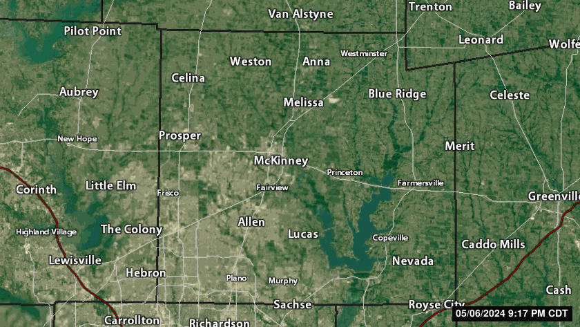
Frisco / Plano / Allen getting round 2 right now from 2nd t-storm.
This post was edited on 5/22/24 at 2:22 pm
Posted on 5/22/24 at 2:23 pm to NorthEndZone
the bottom of the storm skimmed by the family farm on the way out of Collin County
Posted on 5/22/24 at 2:26 pm to chinhoyang
Might be some hail near The Colony based on that radar.
Posted on 5/22/24 at 2:33 pm to NorthEndZone
Loading Twitter/X Embed...
If tweet fails to load, click here. And they followed with this:
quote:
We understand there is a lot of chatter about ratings for various reasons.
Please understand that as damage severity (and by virtue, tor rating) increases, extreme care is taken to ensure assessments are accurate and thorough.
They're the first office I've seen actually address what they knew would be the fallout if that tornado earns an EF3 rating.

Posted on 5/22/24 at 2:39 pm to NorthEndZone
Those storms are producing an outflow boundary that maybe halts things for a minute like last week
Posted on 5/22/24 at 2:47 pm to LegendInMyMind
man that was scary AF - I have been through that town on business before, and it was a nice enough place. i really feel for them.
Posted on 5/22/24 at 3:05 pm to NorthEndZone
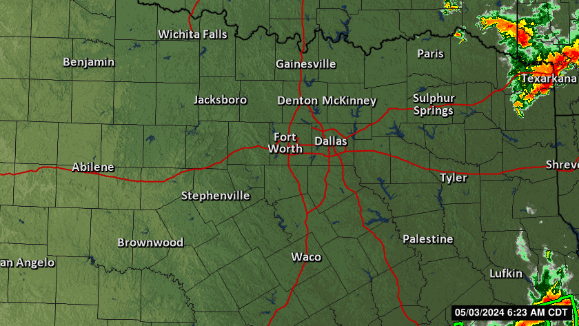
Nasty looking supercell west of Brownwood, TX is now tornado warned for radar indicated rotation.
quote:
BULLETIN - EAS ACTIVATION REQUESTED
Tornado Warning
National Weather Service San Angelo TX
257 PM CDT Wed May 22 2024
The National Weather Service in San Angelo has issued a
* Tornado Warning for...
West central Brown County in west central Texas...
East central Coleman County in west central Texas...
* Until 345 PM CDT.
* At 257 PM CDT, a severe thunderstorm capable of producing a tornado
was located near Valera, moving east at 35 mph.
HAZARD...Tornado and tennis ball size hail.
SOURCE...Radar indicated rotation.
IMPACT...Flying debris will be dangerous to those caught without
shelter. Mobile homes will be damaged or destroyed.
Damage to roofs, windows, and vehicles will occur. Tree
damage is likely.
* This dangerous storm will be near...
Coleman and Santa Anna around 300 PM CDT.
Bangs around 315 PM CDT.
Lake Brownwood around 320 PM CDT.
Lake Brownwood Near Thrifty around 325 PM CDT.
Other locations impacted by this tornadic thunderstorm include Fisk,
Thrifty, and Hords Creek Reservoir.
This post was edited on 5/22/24 at 3:11 pm

Posted on 5/22/24 at 3:27 pm to LegendInMyMind
quote:
They're the first office I've seen actually address what they knew would be the fallout if that tornado earns an EF3 rating.
They in a tizzy over that car lift with the bolts pulled up?
I have been out for a while so I have not seen any updates

Posted on 5/22/24 at 3:34 pm to NorthEndZone
Apparently one of the deaths in Iowa yesterday was a storm chaser. Sad but not surprising since there are so many amateurs chasers out there.
Posted on 5/22/24 at 3:40 pm to red sox fan 13

Posted on 5/22/24 at 3:44 pm to Bobby OG Johnson

Posted on 5/22/24 at 3:46 pm to Bobby OG Johnson
That one could threaten San Angelo, TX if it holds together.
quote:
At 338 PM CDT, a confirmed large and extremely dangerous tornado was located 18 miles south of Sterling City, moving east at 15 mph.
This is a PARTICULARLY DANGEROUS SITUATION. TAKE COVER NOW!
HAZARD...Damaging tornado.
SOURCE...Law enforcement confirmed tornado.
IMPACT...You are in a life-threatening situation. Flying debris may be deadly to those caught without shelter. Mobile homes will be destroyed. Considerable damage to homes, businesses, and vehicles is likely and complete destruction is possible.
This tornadic thunderstorm will remain over mainly rural areas of southern Sterling, northwestern Tom Green and north central Irion Counties.
Posted on 5/22/24 at 3:49 pm to Bobby OG Johnson
Front is closer than models indicated yesterday.
Posted on 5/22/24 at 3:51 pm to 50_Tiger
I always like being outside when an outflow boundary comes over.

 Page 4 of 10

Popular
Back to top