




- My Forums
- Tiger Rant
- LSU Recruiting
- SEC Rant
- Saints Talk
- Pelicans Talk
- More Sports Board
- Fantasy Sports
- Golf Board
- Soccer Board
- O-T Lounge
- Tech Board
- Home/Garden Board
- Outdoor Board
- Health/Fitness Board
- Movie/TV Board
- Book Board
- Music Board
- Political Talk
- Money Talk
- Fark Board
- Gaming Board
- Travel Board
- Food/Drink Board
- Ticket Exchange
- TD Help Board
Customize My Forums- View All Forums
- Show Left Links
- Topic Sort Options
- Trending Topics
- Recent Topics
- Active Topics
Started By
Message
re: Severe weather possible tomorrow.
Posted on 12/22/15 at 7:05 pm to Paul Allen


Posted on 12/22/15 at 7:05 pm to Paul Allen
quote:
For some odd reason areas south of Alexandria don't get the bad tornadoes as compared to the northern part of the state and areas north of Alexandria.
Well the fronts come from the northern west coast and work their way across the country..Some go straight across and some dip south.. They hardly ever dip south enough to get to south LA.. now it does depend on whats east of the front.. But the jet stream usually dips toward Dallas and then shifts to the northeast... Its strange on why.... We would have a better shot of tornados if the storm or front came from south of Mexico by the BAJA coast...
 1
1

Posted on 12/22/15 at 7:16 pm to dukke v
How's my drive from GA to LA tomorrow afternoon looking? fricked...
Posted on 12/22/15 at 7:21 pm to sloopy
quote:
How's my drive from GA to LA tomorrow afternoon looking? fricked...
Yup...You screwed..Alot of rain and wind..But no tornados or hail... What part of GA????
Posted on 12/22/15 at 7:24 pm to dukke v
Atl

Posted on 12/22/15 at 7:33 pm to LSU1NSEC
I found this just now, I think it's just a little overhyped;
Tuesday Night, December 22-23, 2015
Severe thunderstorms mainly after midnight in east TX, west and north LA, AR, southeast OK. TOR:CON - 4 TX, LA, and AR areas; 3 southeast OK.
Wednesday, December 23, 2015
Tornado outbreak likely, possibly starting in the morning, in extreme east TX, LA, MS, AL, northwest GA, west FL panhandle, TN, KY, extreme southwest OH, south and central IN, south and central IL, east-central and south MO, southwest, central and east AR. TOR:CON - 7 west TN, northwest AL, north MS; 6 - southeast MO, south IL, west KY, southeast AR; 5 northeast and central AL, central MS, north LA, northeast AR; 3 to 4 rest of area;
Tuesday Night, December 22-23, 2015
Severe thunderstorms mainly after midnight in east TX, west and north LA, AR, southeast OK. TOR:CON - 4 TX, LA, and AR areas; 3 southeast OK.
Wednesday, December 23, 2015
Tornado outbreak likely, possibly starting in the morning, in extreme east TX, LA, MS, AL, northwest GA, west FL panhandle, TN, KY, extreme southwest OH, south and central IN, south and central IL, east-central and south MO, southwest, central and east AR. TOR:CON - 7 west TN, northwest AL, north MS; 6 - southeast MO, south IL, west KY, southeast AR; 5 northeast and central AL, central MS, north LA, northeast AR; 3 to 4 rest of area;


Posted on 12/22/15 at 7:49 pm to Boston911
Damn looks like i'm in that 70% zone


Posted on 12/22/15 at 7:50 pm to Boston911
For Wednesday
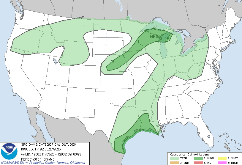
quote:
DAY 2 CONVECTIVE OUTLOOK NWS STORM PREDICTION CENTER NORMAN OK 1130 AM CST TUE DEC 22 2015 VALID 231200Z - 241200Z ...THERE IS AN ENH RISK OF SVR TSTMS FROM THE LOWER MS VALLEY INTO THE TN VALLEY... ...THERE IS A SLGT RISK OF SVR TSTMS FROM THE CNTRL GULF COAST TO JUST SOUTH OF CHICAGO... ...THERE IS A MRGL RISK OF SVR TSTMS SURROUNDING THE SLGT RISK FROM THE UPPER TX COAST TO SRN LOWER MI... ...SUMMARY... THE POTENTIAL FOR SEVERE THUNDERSTORMS WILL EXTEND FROM THE CENTRAL GULF COAST TO THE LOWER GREAT LAKES REGION ON WEDNESDAY INTO WEDNESDAY NIGHT. THE GREATEST POTENTIAL FOR SEVERE THUNDERSTORMS IS FORECAST FROM PORTIONS OF THE MID-SOUTH REGION TO THE TENNESSEE VALLEY...WHERE TORNADOES...SOME SIGNIFICANT...ALONG WITH DAMAGING WINDS AND HAIL WILL BE POSSIBLE. ...DISCUSSION... STRONG HIGH-LEVEL FLOW IS FORECAST TO TRANSLATE ALONG A CORRIDOR FROM THE GREAT BASIN...INTO THE BASE OF CNTRL U.S. TROUGH OVER TX...THEN NEWD INTO THE GREAT LAKES EARLY IN THE PERIOD. FOCUSED 12HR MID-LEVEL HEIGHT FALLS WILL SHIFT FROM KS/OK INTO THE UPPER GREAT LAKES BY LATE AFTERNOON AS SFC CYCLONE SHIFTS FROM NERN KS INTO THE U.P. OF MI. IN RESPONSE TO THIS LARGE-SCALE ADJUSTMENT...STRONG WARM ADVECTION WILL BE RESPONSIBLE FOR LATE DAY1 INTO EARLY DAY2 CONVECTION ACROSS MUCH OF THE GULF STATES AND MID-SOUTH REGION. THIS EARLY PERIOD TSTM ACTIVITY WILL INHIBIT DESTABILIZATION WITHIN BROADER RECOVERY PORTIONS OF THE OH/ERN TN VALLEY. LATEST THINKING IS A PW SURGE WILL ADVANCE NWD ACROSS ERN TX/OK LATE DAY1 AHEAD OF SURGING COLD FRONT. THIS MOISTURE PLUME SHOULD SHIFT INTO THE LOWER/MID MS VALLEY BY MID DAY AND THE MOST SIGNIFICANT DESTABILIZATION IS EXPECTED ALONG WRN FRINGE OF AFOREMENTIONED WARM ADVECTION TSTM ACTIVITY. LATEST MODEL GUIDANCE SUGGESTS STRONGEST BOUNDARY LAYER HEATING AND STEEPEST LOW-LEVEL LAPSE RATES WILL EVOLVE FROM CNTRL AR...NEWD INTO IL. IF SUFFICIENT LOW-LEVEL MOISTURE CAN RETURN INTO THIS CORRIDOR THEN A MORE CONCENTRATED AREA OF STRONG/SEVERE TSTMS CAN BE EXPECTED AHEAD OF COLD FRONT. AT THIS TIME IT APPEARS ROBUST UPDRAFTS WILL DEVELOP BY MID DAY ACROSS AR/NRN LA THEN TRACK NEWD INTO THE WRN TN VALLEY. VERY STRONG SHEAR ALONG SRN FRINGES OF MID-LEVEL HEIGHT FALL REGION APPEARS TO BE THE FAVORED CORRIDOR FOR POTENTIAL LONG-LIVED SUPERCELLS AND PERHAPS A FEW STRONG TORNADOES. IF SUFFICIENT BUOYANCY CAN DEVELOP FARTHER NORTH ACROSS IL/IND THEN A DAMAGING SQUALL LINE COULD EVOLVE WITH SEVERE WIND GUSTS. STRONG FORCING WILL BE MORE SUPPORTIVE OF A LINEAR MCS ACROSS THE OH VALLEY AS 90KT 500MB SPEED MAX EJECTS INTO THIS REGION DURING THE EVENING HOURS. FOR THIS REASON HAVE EXPANDED SEVERE PROBS A BIT NORTH TO ACCOUNT FOR STRONG FORCING.
Posted on 12/22/15 at 7:52 pm to sloopy
quote:
Atl
The farther south you go the better[kinda]. If you are coming to the BR area, Getting to I-10 as soon as you can will be the easiest route to avoid the real bad stuff...
Posted on 12/22/15 at 7:55 pm to dukke v
i'm gonna be pissed if storm chasers show up in my area tomorrow
Posted on 12/22/15 at 7:56 pm to TheCaterpillar
quote:
I'm driving from Nashville to Jackson, MS at 4 pm tomorrow.
If your going to Jackson, weather would be the least of my worries.

Posted on 12/22/15 at 7:59 pm to LSU1NSEC
quote:
i'm gonna be pissed if storm chasers show up in my area tomorrow
And where is that????
Posted on 12/22/15 at 8:04 pm to dukke v
southwest LA

Posted on 12/22/15 at 8:24 pm to LSU1NSEC
Where the hell is geauxmedic with all of our maps?


Posted on 12/22/15 at 8:25 pm to captainahab

Posted on 12/22/15 at 8:45 pm to HoLeInOnEr05
I always look at TVNweather stormchaser map in severe weather. If you see a bunch of them piled up in an area you know something's up.
LINK
LINK
Posted on 12/22/15 at 9:05 pm to LSU1NSEC
quote:
southwest LA
You will be fine as far as tornados and hail... Prob some wind and spots of heavy rain...........

Posted on 12/22/15 at 9:06 pm to Paul Allen
i only see 50% chance of rain south louisiana tomorrow where i am. but i think either thurs or friday is big time rain. idk
Posted on 12/22/15 at 9:13 pm to beauchristopher
quote:
i only see 50% chance of rain south louisiana tomorrow where i am
You must be in SW La... But it will rain both Thursday and xmas.... Another system is on the west coast as of now and it will reach us by then... Just a shitload of rain this whole week. Covering the whole state... No droughts anymore here...


Posted on 12/22/15 at 9:43 pm to beauchristopher
Been raining in Metairie since lunchtime

Posted on 12/22/15 at 9:46 pm to dukke v
quote:
From where to where???? There will be a break in the A.M. Not sure who makes the call on the flying in though.. Check the weather and get with those who make those choices.....
You're fricked, kiss of peej'd
This post was edited on 12/22/15 at 9:47 pm

 Page 3 of 5

Popular
Back to top
 Follow TigerDroppings for LSU Football News