- My Forums
- Tiger Rant
- LSU Recruiting
- SEC Rant
- Saints Talk
- Pelicans Talk
- More Sports Board
- Coaching Changes
- Fantasy Sports
- Golf Board
- Soccer Board
- O-T Lounge
- Tech Board
- Home/Garden Board
- Outdoor Board
- Health/Fitness Board
- Movie/TV Board
- Book Board
- Music Board
- Political Talk
- Money Talk
- Fark Board
- Gaming Board
- Travel Board
- Food/Drink Board
- Ticket Exchange
- TD Help Board
Customize My Forums- View All Forums
- Show Left Links
- Topic Sort Options
- Trending Topics
- Recent Topics
- Active Topics
Started By
Message
 2
2

Posted on 4/9/21 at 9:17 pm to LegendInMyMind
Madison count MS we are getting a. shite ton of lightning and 60 MPH wind gusts

Posted on 4/9/21 at 9:19 pm to LegendInMyMind
quote:
NWS Memphis
@NWSMemphis
Damaging winds moving across Monroe County. Take cover now!#mswx
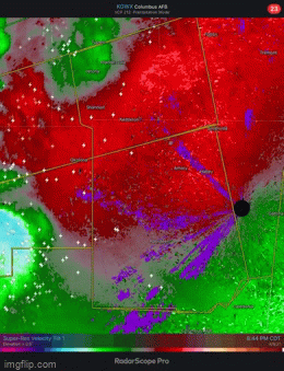
Posted on 4/9/21 at 9:22 pm to Bobby OG Johnson
quote:
RadarOmega
@RadarOmega_WX
Dangerous storms with potential for 80 MPH wind gusts are moving through south of Tupelo, MS. Severe Thunderstorm Warning including Amory MS, Aberdeen MS, Fulton MS until 10:00 PM CDT!

Posted on 4/9/21 at 9:25 pm to Bobby OG Johnson


Posted on 4/9/21 at 9:35 pm to rt3
For Alabama and Mississippi folks, note that this current line is not the end of this. Sounds like another line will form back near the Mississippi River around or after midnight and March eastward during the overnight and morning hours.
Posted on 4/9/21 at 9:36 pm to rt3
I'm just going to sit here and wait. Figuring out which part of the line is going to come over us is impossible with the speed and every track pointing a different direction.
Posted on 4/9/21 at 9:50 pm to Roll Tide Ravens
quote:
another line will form back near the Mississippi River around or after midnight and March eastward during the overnight and morning hours.
Yep...it’s particularly dangerous due to the time of night that it will come through. It will hit my area at about 1:30 am and the Alabama line at around 3 AM
Posted on 4/9/21 at 9:54 pm to Spankum
Quick note, the HRRR continues to show a high wind threat for the gulf coast as the line comes down. Louisiana being home to the most instability. Wouldn't be surprised if this comes through with a roar overnight.
NAM looks about the same.
NAM looks about the same.
This post was edited on 4/9/21 at 9:56 pm
Posted on 4/9/21 at 10:00 pm to Duke
I’ll say this, I got 4.04” of rain today from severe storms where I live north of Birmingham. I really hope I avoid getting 1-2 more inches of rain through tomorrow morning.
Posted on 4/9/21 at 10:02 pm to Roll Tide Ravens
You can see what should be the second line forming back in eastern Oklahoma.
Posted on 4/9/21 at 10:04 pm to Roll Tide Ravens
Going to be interested to see if line two catches line one or not.
Posted on 4/9/21 at 10:07 pm to Roll Tide Ravens
quote:
I’ll say this, I got 4.04” of rain today from severe storms where I live north of Birmingham
Got less than half inch SW of Bham
Posted on 4/9/21 at 10:09 pm to Duke
Brett

quote:
Tornado a little earlier near Pelahatchie, MS. #MSwx
Posted on 4/9/21 at 10:15 pm to Bobby OG Johnson
Were there ever any damage reports from that? That pic is a pic of a still on his camera. Zoomed in it looks like you can see lightning through the funnel. Hard to tell if it ever touched down. Even Brett said on the stream he couldn't tell if it fully touched down.
Posted on 4/9/21 at 10:17 pm to LegendInMyMind
This first line looks to be losing steam as it moves into Alabama. Just one severe thunderstorm warning as it approaches the state line, West of Tuscaloosa.
This post was edited on 4/9/21 at 10:20 pm
Posted on 4/9/21 at 10:20 pm to LegendInMyMind
I think I heard the cop he was talking to say that area was woods. Said if it was down then it was not down long.
Posted on 4/9/21 at 10:40 pm to rt3
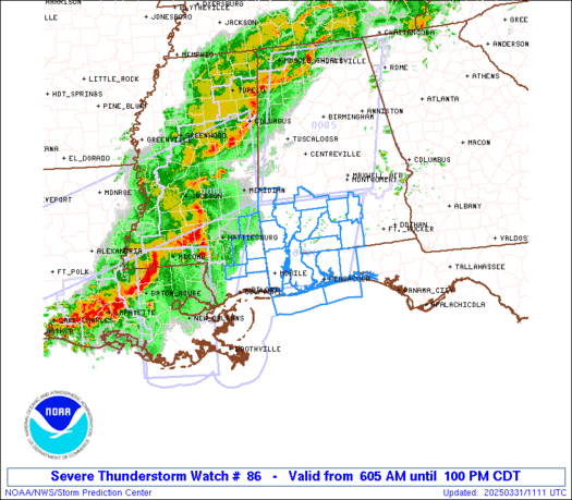
New Severe Thunderstorm Watch includes Baton Rouge
This post was edited on 4/9/21 at 10:41 pm
Posted on 4/9/21 at 10:41 pm to NorthEndZone

Posted on 4/9/21 at 11:02 pm to rt3
Where do you get those notifications? Which app?

 Page 22 of 28

Popular
Back to top