- My Forums
- Tiger Rant
- LSU Recruiting
- SEC Rant
- Saints Talk
- Pelicans Talk
- More Sports Board
- Coaching Changes
- Fantasy Sports
- Golf Board
- Soccer Board
- O-T Lounge
- Tech Board
- Home/Garden Board
- Outdoor Board
- Health/Fitness Board
- Movie/TV Board
- Book Board
- Music Board
- Political Talk
- Money Talk
- Fark Board
- Gaming Board
- Travel Board
- Food/Drink Board
- Ticket Exchange
- TD Help Board
Customize My Forums- View All Forums
- Show Left Links
- Topic Sort Options
- Trending Topics
- Recent Topics
- Active Topics
Started By
Message
re: Severe Weather for Friday
Posted on 4/9/21 at 12:06 pm to udtiger
Posted on 4/9/21 at 12:06 pm to udtiger
@TTrogdon
quote:
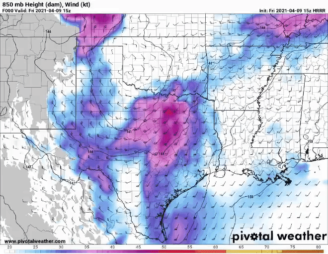
Confidence is increasing in a widespread damaging wind event this afternoon. The HRRR is explicitly modeling a strong rear inflow jet immediately behind the squall line passage as a result of an intense pressure couplet. If this materializes, a high-end wind event is possible. LINK
 0
0

Posted on 4/9/21 at 12:24 pm to udtiger
Severe T-Storm Watch until 6 PM...
Posted on 4/9/21 at 12:28 pm to NorthEndZone
The storm near Mount Pleasant/Naples, TX may be the first big hailer of the day. It has been going a while.
Posted on 4/9/21 at 12:41 pm to LegendInMyMind
To whoever asked yeaterday about Alabama beach weather today/tomorrow:
Posted on 4/9/21 at 12:50 pm to LegendInMyMind
Looks like just after 7 AM when SE LA will get the squall line,
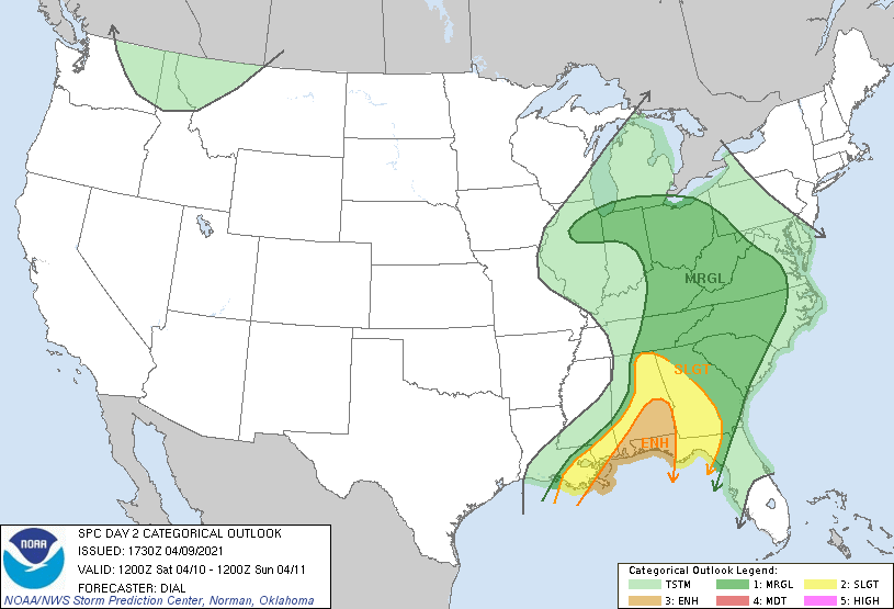
Day 2 Convective Outlook
NWS Storm Prediction Center Norman OK
1230 PM CDT Fri Apr 09 2021
Valid 101200Z - 111200Z
...THERE IS AN ENHANCED RISK OF SEVERE THUNDERSTORMS OVER A PORTION
OF THE GULF COAST STATES...
...SUMMARY...
Scattered severe thunderstorms are expected from southeast Louisiana
eastward to the Florida Panhandle, and northward into Alabama and
western Georgia Saturday. Damaging wind appears to be the main
threat, but isolated tornadoes are also possible.
...Synopsis...
Within a broad synoptic upper trough a shortwave trough will move
from the middle MS Valley early Saturday into the OH Valley later in
the afternoon. A low-amplitude southern-stream shortwave trough will
move along the Gulf Coast then northeast into the Carolinas by late
afternoon and evening. By 12Z Saturday a cold front will extend from
a low near St. Louis southwestward into the lower MS Valley and
southeast TX. A warm front will extend southeast from the surface
low through the TN Valley and Southeast States. The surface low will
lift northward to near the Chicago area by late afternoon while the
cold front continues east through the OH/TN Valleys and into the
southeast States. By early evening the warm front should extend from
the surface low southeast through the OH Valley and into the Middle
Atlantic area.
...Gulf Coast States...
It is likely that storms will have consolidated into an organized
squall line by 12Z Saturday with embedded mesovortices and bowing
structures. A few discrete supercells may also be ongoing ahead of
the line. These storms will be embedded within strong deep-layer
winds and accompanying intense (60+ kt) low-level jet associated
with the southern-stream shortwave trough. Effective bulk shear from
40-50 kt and large 0-1 km hodographs will support the potential for
scattered damaging wind and isolated significant wind damage as well
as a few tornadoes, as storms advance east through the moist and
moderately unstable warm sector across southern portions of the Gulf
Coast states during the day.
Posted on 4/9/21 at 12:56 pm to NorthEndZone
@NickLilja
quote:
The CAMs guidance showing the outflow from afternoon AL/FL convection sliding back west into a rather potent environment in south Mississippi overnight is... in a word... troubling.
quote:
For two reasons...
1 - any storms initiated along that boundary would have a bit of extra low-level torque
2 - as the line interacts with that boundary, it may offer an extra bump in surface-based lift, low-level shear, or both.
Posted on 4/9/21 at 12:59 pm to NorthEndZone
HEADS-UP for you Bama guys...
Posted on 4/9/21 at 1:10 pm to NorthEndZone
Big hail in Alabama already
quote:
1215
2.50
4 SSE COFFEEVILLE CLARKE AL
HAIL UP TO TENNIS BALL SIZE REPORTED ON HIGHWAY 69 BETWEEN COFFEEVILLE AND SALITPA. THE HAIL RESULTED IN VEHICLE DAMAGE. (MOB)
Posted on 4/9/21 at 1:12 pm to LegendInMyMind
quote:
For two reasons...
1 - any storms initiated along that boundary would have a bit of extra low-level torque
2 - as the line interacts with that boundary, it may offer an extra bump in surface-based lift, low-level shear, or both.
He's right and I share his concerns. Storms getting rooted in a boundary are great way to get strong to violent tornados in otherwise not amazing tor environments.
The HRRR really wants to throw up a cluster into that region before lining up with the rest of it.
In general, the high wind threat is screaming out with the noontime guidance. About time to pull up the Mesoscale Analysis for the SE and bust out the GRLevel3 (my level 2 trial ended

Posted on 4/9/21 at 1:45 pm to NorthEndZone
I’m in a whale of a storm in Jefferson County, AL right now.

Posted on 4/9/21 at 2:10 pm to Roll Tide Ravens
quote:
WSFA 12 News
@wsfa12news
CAUGHT ON CAMERA: Lightning obliterates tree outside high school in Wis.

https://www.wsfa.com/2021/04/09/caught-camera-lightning-obliterates-tree-outside-high-school-wis/
This post was edited on 4/9/21 at 2:13 pm
Posted on 4/9/21 at 2:16 pm to Duke
quote:
About time to pull up the Mesoscale Analysis for the SE and bust out the GRLevel3 (my level 2 trial ended ) for watching this evening.
Re-up, baw....I could use a log-in!
Posted on 4/9/21 at 2:18 pm to Bobby OG Johnson
Currently fishing out of the big boat at the Chandeleur Islands. What time is this supposed to hit? Did not realize it was going to be that big of an event and now I'm thinking we need to pick up anchor and start heading back.
Posted on 4/9/21 at 2:20 pm to Duke
Anyone here know how the mPING Reports are made on RadarScope?
Posted on 4/9/21 at 2:23 pm to LegendInMyMind
You just click the share button them mPING
Posted on 4/9/21 at 2:24 pm to MrLSU
quote:
Currently fishing out of the big boat at the Chandeleur Islands. What time is this supposed to hit? Did not realize it was going to be that big of an event and now I'm thinking we need to pick up anchor and start heading back.
You have the risk of some pop-up storms throughout the day, I'm sure. Any those could go severe. You want no part of that line when it comes through in the morning. Not knowing much about the area, that's all I can really say.
Posted on 4/9/21 at 2:26 pm to BPTiger
quote:
You just click the share button them mPING
Well, that makes too much sense. For as long as I've used RadarScope, I've never paid attention to it.
Posted on 4/9/21 at 2:29 pm to LegendInMyMind
Pretty stout storm Northeast of Jasper, AL.
Posted on 4/9/21 at 2:34 pm to LegendInMyMind
quote:
Pretty stout storm Northeast of Jasper, AL.
Yep, the hail core looks nasty.

Posted on 4/9/21 at 2:35 pm to Roll Tide Ravens
I had some of the worst hail I can remember where I am north of Birmingham a little while ago. It was mostly small hail, but it was falling at a tremendous rate at one point. I did get some hail up to quarter size.

 Page 16 of 28

Popular
Back to top