




- My Forums
- Tiger Rant
- LSU Recruiting
- SEC Rant
- Saints Talk
- Pelicans Talk
- More Sports Board
- Fantasy Sports
- Golf Board
- Soccer Board
- O-T Lounge
- Tech Board
- Home/Garden Board
- Outdoor Board
- Health/Fitness Board
- Movie/TV Board
- Book Board
- Music Board
- Political Talk
- Money Talk
- Fark Board
- Gaming Board
- Travel Board
- Food/Drink Board
- Ticket Exchange
- TD Help Board
Customize My Forums- View All Forums
- Show Left Links
- Topic Sort Options
- Trending Topics
- Recent Topics
- Active Topics
Started By
Message


 1
1


Posted on 5/29/19 at 11:42 am to LSUFanHouston
quote:
And yet we only get to a 3 on the chart?
The line and anything discrete will blow up over the metro area due to instability.
The area of concern though lies more to the NE section of the metro area.

Posted on 5/29/19 at 11:43 am to Duke
quote:
Suspect rotation out near Weatherford.
Damn - my SO's son lives in Weatherford on the Brazos.
Posted on 5/29/19 at 11:50 am to blueridgeTiger
Tornado Warning - Bethel Heights, AR

Posted on 5/29/19 at 11:54 am to GreatLakesTiger24
A shite ton of rain and some thunder just moved through Plano. I'm at W. Park and the Tollway now.

Posted on 5/29/19 at 11:55 am to 50_Tiger
Used to love watching the storms roll in from the west from the 11th at the Caremark (CVS) building. Wouldn't get anything done between that and watching planes land.


Posted on 5/29/19 at 11:57 am to 50_Tiger
I’m bout done with the daily severe weather threats


Posted on 5/29/19 at 11:57 am to Sao
Just got back from Rudy's in Frisco, it be flooding.
Posted on 5/29/19 at 11:58 am to MaHittaMaHitta
quote:
A shite ton of rain and some thunder just moved through Plano. I'm at W. Park and the Tollway now.
Close to me!
Getting another cell again. Wind and rain so far, nothing too crazy. But it does seem like were getting a training effect through the heart of the metro area
Posted on 5/29/19 at 12:14 pm to 50_Tiger
quote:Where you working baw?
Close to me!
Looks like the sun is trying to peek out now.

Posted on 5/29/19 at 12:16 pm to MaHittaMaHitta
WFH today. Frankford/Tollway.
Office is in Las Colinas John Parker/Connection Dr.
Office is in Las Colinas John Parker/Connection Dr.


Posted on 5/29/19 at 12:20 pm to MaHittaMaHitta
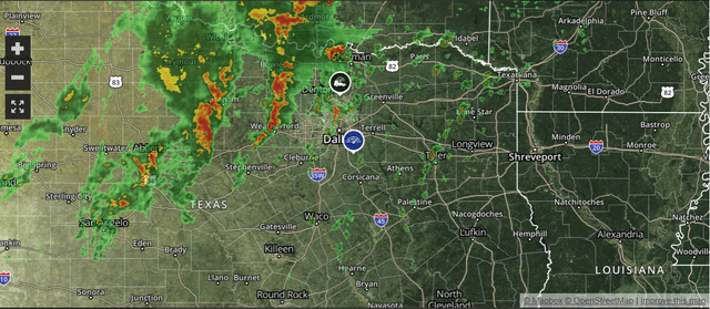
Sunny in Dallas, but I can see the bad stuff to the north.
Posted on 5/29/19 at 12:35 pm to TH03
quote:
Sunny in Dallas, but I can see the bad stuff to the north.
That was the appetizer for the main course later today. The question is if it jacked the atmosphere up enough to make the late afternoon weaker?


Posted on 5/29/19 at 12:52 pm to DarthRebel
Walmart's main pharmaceutical distribution warehouse in Bentonville just went offline. No Oxy's for the Ozark junkies for a while.

Posted on 5/29/19 at 12:54 pm to 50_Tiger
Just got the Tornado Watch text
Posted on 5/29/19 at 12:59 pm to The Torch

quote:
URGENT - IMMEDIATE BROADCAST REQUESTED
Tornado Watch Number 293
NWS Storm Prediction Center Norman OK
1245 PM CDT Wed May 29 2019
The NWS Storm Prediction Center has issued a
* Tornado Watch for portions of
Parts of western and northern Arkansas
Southeastern Oklahoma
Parts of north central and northeastern Texas
* Effective this Wednesday afternoon and evening from 1245 PM
until 800 PM CDT.
* Primary threats include...
A few tornadoes likely
Scattered large hail and isolated very large hail events to 3
inches in diameter likely
Scattered damaging wind gusts to 70 mph likely
SUMMARY...Ongoing storms from north Texas into northwestern Arkansas
will continue to spread eastward through the afternoon. Additional
warm sector, discrete storm development appears likely from
northeast Texas into western Arkansas through the afternoon. The
storm environment is supportive of supercells with very large hail,
as well as storm clusters capable of damaging gusts. Though
low-level shear is not particularly strong, some of the discrete
storms and/or storm interactions could pose a tornado threat, as
well as circulations embedded in line segments resulting from
upscale growth.

Posted on 5/29/19 at 1:00 pm to The Torch
We just got a tornado warning text in Coppell.
Posted on 5/29/19 at 1:00 pm to The Torch
That cell heading for NW Fort Worth is looking ominous. Slight rotation possible.


Posted on 5/29/19 at 1:01 pm to LaBR4
Its still sunny in Dallas. People are gonna start calling for the heads of meteorologists.
Posted on 5/29/19 at 1:02 pm to NorthEndZone

Get ready baws its spinning

 Page 2 of 10

Popular
Back to top
 Follow TigerDroppings for LSU Football News