- My Forums
- Tiger Rant
- LSU Recruiting
- SEC Rant
- Saints Talk
- Pelicans Talk
- More Sports Board
- Fantasy Sports
- Golf Board
- Soccer Board
- O-T Lounge
- Tech Board
- Home/Garden Board
- Outdoor Board
- Health/Fitness Board
- Movie/TV Board
- Book Board
- Music Board
- Political Talk
- Money Talk
- Fark Board
- Gaming Board
- Travel Board
- Food/Drink Board
- Ticket Exchange
- TD Help Board
Customize My Forums- View All Forums
- Show Left Links
- Topic Sort Options
- Trending Topics
- Recent Topics
- Active Topics
Started By
Message
re: Severe Weather 4/19 Thread | Multiple Tornadoes in Midwest | At least 2 fatalities
Posted on 4/19/23 at 8:06 pm to Roll Tide Ravens

Posted on 4/19/23 at 8:06 pm to Roll Tide Ravens
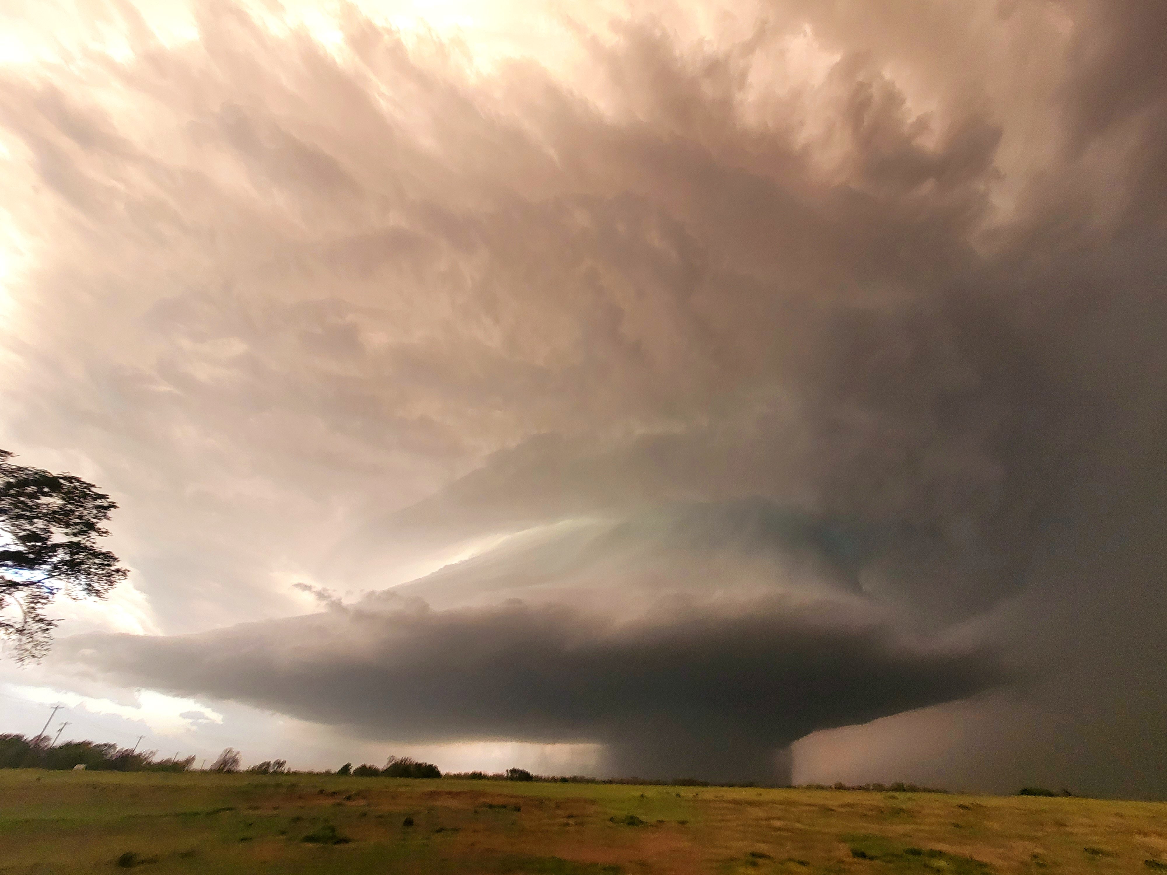
You can see how this cell is cycling on radar.

 0
0

Posted on 4/19/23 at 8:06 pm to LegendInMyMind
quote:
There have been splits and mergers and more mergers and more splits. Storms looked like the three stooges running into each other. This one found a groove.
Pretty crazy how quick it happened.
Posted on 4/19/23 at 8:09 pm to razorbackfan4life
just looking at radar that cell in kansas looks pretty rough
Posted on 4/19/23 at 8:13 pm to razorbackfan4life
quote:
Pretty crazy how quick it happened.
When it finally wrapped up it dropped one quick, but this whole process has been hours in the making.

Posted on 4/19/23 at 8:14 pm to razorbackfan4life
quote:
Cameron Nixon
@CameronJNixon
Incredible supercell E Lexington #okwx
Posted on 4/19/23 at 8:16 pm to Bobby OG Johnson
Those two cells to the SW of the tor warned one could be trouble. They may merge, or the southern one cuts off the one to the north. They're looking better over the past few scans.
Posted on 4/19/23 at 8:22 pm to vuvuzela
quote:
just looking at radar that cell in kansas looks pretty rough
It has a funnel, per the warning/spotters. Looks close to putting one down.
Posted on 4/19/23 at 8:23 pm to LegendInMyMind
quote:
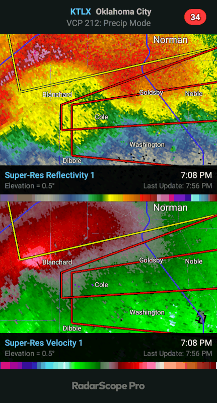
However, a storm merger in McClain county combined with increasing SRH as the low-level jet strengthens led to a strong tornado with a TDS above 10kft and a Vrot of 80-85 knots with a STP of 3-4. This suggests damage potential consistent with a strong to intense tornado (potentially 150+ mph)
From SPC regarding that tornado SW of Norman at 8:02 central.
This post was edited on 4/19/23 at 8:24 pm
Posted on 4/19/23 at 8:23 pm to LegendInMyMind
quote:
When it finally wrapped up it dropped one quick, but this whole process has been hours in the making.
Memorable tornado for sure.
It almost did a 360 before it folded over on itself.
Hopefully someone can post the radar loop of the tornado.
This post was edited on 4/19/23 at 8:25 pm

Posted on 4/19/23 at 8:26 pm to Wishnitwas1998
baton rouge gonna get it bad?
Posted on 4/19/23 at 8:27 pm to Topisawtiger
quote:
Just landed in OKC, sitting on runway. Hailing like crazy. Damn this sucks.
Is this your flight?
Twitter LINK
Posted on 4/19/23 at 8:28 pm to trussthetruzz
Unsure of the exact timing but not tonight
There's some severe risk in Tennsippibama Friday evening around 5 pm or so so possibly that morning Or Thursday night
There's some severe risk in Tennsippibama Friday evening around 5 pm or so so possibly that morning Or Thursday night
This post was edited on 4/19/23 at 8:29 pm
Posted on 4/19/23 at 8:28 pm to razorbackfan4life
Hailing here at the airport went 2 rounds, 30 minutes total. Stopped, now hailing for a third time. We are still stuck on the runway. This is insane.
Posted on 4/19/23 at 8:28 pm to razorbackfan4life
quote:
Hopefully someone can post the radar loop of the tornado.
Early life:
Deviant left turn and occlusion:


Posted on 4/19/23 at 8:29 pm to LegendInMyMind
Pretty nasty warned cell just west of emporia Kansas
ETA: video of a funnel on tv now. A lot of rain so can’t tell if it’s in the ground from their video.
Eta2: just a funnel but it’s trying it’s damndest to drop
ETA: video of a funnel on tv now. A lot of rain so can’t tell if it’s in the ground from their video.
Eta2: just a funnel but it’s trying it’s damndest to drop
This post was edited on 4/19/23 at 8:31 pm
Posted on 4/19/23 at 8:29 pm to LegendInMyMind
quote:
When it finally wrapped up it dropped one quick, but this whole process has been hours in the making.
Watching Reed move in and reverse out as he could sense the danger was pretty damn cool to watch.
Posted on 4/19/23 at 8:30 pm to LegendInMyMind
And the Kansas storm is confirmed now. Pretty clear even without a stout CC drop.
Posted on 4/19/23 at 8:30 pm to LegendInMyMind
That circulation in Strong City, KS looks to be on the ground now.
Posted on 4/19/23 at 8:30 pm to LegendInMyMind
quote:
It has a funnel, per the warning/spotters. Looks close to putting one down.
Confirmed tornado now on that one, wibw news has a camera on it.
This post was edited on 4/19/23 at 8:31 pm
Posted on 4/19/23 at 8:31 pm to Bobby OG Johnson
quote:
Watching Reed move in and reverse out as he could sense the danger was pretty damn cool to watch.
That's experience, and is why he can do what he can do and others can't do what he can do.
This post was edited on 4/19/23 at 8:31 pm

 Page 4 of 11

Popular
Back to top