




 0
0









- My Forums
- Tiger Rant
- LSU Recruiting
- SEC Rant
- Saints Talk
- Pelicans Talk
- More Sports Board
- Fantasy Sports
- Golf Board
- Soccer Board
- O-T Lounge
- Tech Board
- Home/Garden Board
- Outdoor Board
- Health/Fitness Board
- Movie/TV Board
- Book Board
- Music Board
- Political Talk
- Money Talk
- Fark Board
- Gaming Board
- Travel Board
- Food/Drink Board
- Ticket Exchange
- TD Help Board
Customize My Forums- View All Forums
- Show Left Links
- Topic Sort Options
- Trending Topics
- Recent Topics
- Active Topics
Started By
Message
re: Severe Weather - Today - LA, MS, AL, NW FL
Posted on 4/18/19 at 2:18 pm to MorbidTheClown
Posted on 4/18/19 at 2:18 pm to MorbidTheClown
Big pocket of high winds coming in off the gulf just SE of New Iberia on radar.
Posted on 4/18/19 at 2:18 pm to Cowboyfan89
quote:
Thankfully, it never got real crazy here

Hope you're doing well, Tex.
Posted on 4/18/19 at 2:18 pm to MorbidTheClown
Shits bad over here.

Posted on 4/18/19 at 2:18 pm to Cowboyfan89
(no message)
This post was edited on 4/20/19 at 7:52 am
Posted on 4/18/19 at 2:19 pm to rt3
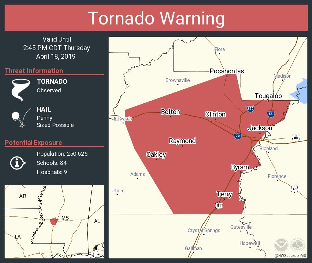
PDS WARNING -- Headed toward Clinton NW of Jackson
214 PM CDT THU APR 18 2019
...A TORNADO WARNING REMAINS IN EFFECT UNTIL 245 PM CDT FOR HINDS AND
NORTH CENTRAL COPIAH COUNTIES...
At 213 PM CDT, a confirmed large and extremely dangerous tornado was
located near Raymond, or 13 miles southwest of Clinton, moving
northeast at 40 mph.
This is a PARTICULARLY DANGEROUS SITUATION. TAKE COVER NOW!
HAZARD...Damaging tornado.
SOURCE...Radar confirmed tornado.
IMPACT...You are in a life-threatening situation. Flying debris may
be deadly to those caught without shelter. Mobile homes
will be destroyed. Considerable damage to homes,
businesses, and vehicles is likely and complete destruction
is possible.
The tornado will be near...
Raymond and Bolton around 225 PM CDT.
Jackson around 230 PM CDT.
Clinton around 235 PM CDT.
Other locations impacted by this tornadic thunderstorm include
Learned.
PRECAUTIONARY/PREPAREDNESS ACTIONS...
To repeat, a large, extremely dangerous and potentially deadly
tornado is on the ground. To protect your life, TAKE COVER NOW! Move
to a basement or an interior room on the lowest floor of a sturdy
building. Avoid windows. If you are outdoors, in a mobile home, or in
a vehicle, move to the closest substantial shelter and protect
yourself from flying debris.
214 PM CDT THU APR 18 2019
...A TORNADO WARNING REMAINS IN EFFECT UNTIL 245 PM CDT FOR HINDS AND
NORTH CENTRAL COPIAH COUNTIES...
At 213 PM CDT, a confirmed large and extremely dangerous tornado was
located near Raymond, or 13 miles southwest of Clinton, moving
northeast at 40 mph.
This is a PARTICULARLY DANGEROUS SITUATION. TAKE COVER NOW!
HAZARD...Damaging tornado.
SOURCE...Radar confirmed tornado.
IMPACT...You are in a life-threatening situation. Flying debris may
be deadly to those caught without shelter. Mobile homes
will be destroyed. Considerable damage to homes,
businesses, and vehicles is likely and complete destruction
is possible.
The tornado will be near...
Raymond and Bolton around 225 PM CDT.
Jackson around 230 PM CDT.
Clinton around 235 PM CDT.
Other locations impacted by this tornadic thunderstorm include
Learned.
PRECAUTIONARY/PREPAREDNESS ACTIONS...
To repeat, a large, extremely dangerous and potentially deadly
tornado is on the ground. To protect your life, TAKE COVER NOW! Move
to a basement or an interior room on the lowest floor of a sturdy
building. Avoid windows. If you are outdoors, in a mobile home, or in
a vehicle, move to the closest substantial shelter and protect
yourself from flying debris.
Posted on 4/18/19 at 2:19 pm to Cowboyfan89

Posted on 4/18/19 at 2:19 pm to NorthEndZone
..A TORNADO WARNING REMAINS IN EFFECT UNTIL 245 PM CDT FOR HINDS AND
NORTH CENTRAL COPIAH COUNTIES...
At 213 PM CDT, a confirmed large and extremely dangerous tornado was
located near Raymond, or 13 miles southwest of Clinton, moving
northeast at 40 mph.
This is a PARTICULARLY DANGEROUS SITUATION. TAKE COVER NOW!
NORTH CENTRAL COPIAH COUNTIES...
At 213 PM CDT, a confirmed large and extremely dangerous tornado was
located near Raymond, or 13 miles southwest of Clinton, moving
northeast at 40 mph.
This is a PARTICULARLY DANGEROUS SITUATION. TAKE COVER NOW!
Posted on 4/18/19 at 2:19 pm to Large Farva
quote:
Nola always getting spared during these end of the world events.
Actually, NOLA gets hit by a tornado every time. You just can't tell the before and after photos apart.
Posted on 4/18/19 at 2:19 pm to rt3

Posted on 4/18/19 at 2:20 pm to rt3
TWC saying the tornado headed toward Jackson has been VISUALLY confirmed by a human (storm spotter)
Posted on 4/18/19 at 2:20 pm to TDsngumbo
quote:
Damn. That intensified quickly.
LCA just finished an eyewall replacement cycle.
Posted on 4/18/19 at 2:21 pm to rt3
Tracking towards Clinton, North Jackson, and Madison if it holds together. Not good.
Posted on 4/18/19 at 2:21 pm to rt3
quote:
TWC saying the tornado headed toward Jackson has been VISUALLY confirmed by a human (storm spotter)
Large tornado too.
Posted on 4/18/19 at 2:21 pm to rt3
quote:
(storm spotter)
Posted on 4/18/19 at 2:22 pm to rt3
Posted on 4/18/19 at 2:22 pm to Cowboyfan89
quote:
Thankfully, it never got real crazy here in Opelousas
WHY would anyone want to live there??????
Posted on 4/18/19 at 2:23 pm to rt3
quote:
NWS Jackson MS @NWSJacksonMS
Confirmed tornado was spotted along Dry Grove Road in Raymond along Highway 18. Stay in your safe place and take cover now!!
Posted on 4/18/19 at 2:23 pm to rt3
Bad tornado in Raymond. School bus trapped. Dry grove, hwy 18. shite ain't good.
This post was edited on 4/18/19 at 2:24 pm
Posted on 4/18/19 at 2:23 pm to rt3
Been spared so far in Norco. Just passing cells
Posted on 4/18/19 at 2:23 pm to dukke v
quote:
WHY would anyone want to live there??????
was great in the 70s

 Page 49 of 69



Popular

Back to top
 Follow TigerDroppings for LSU Football News