





 0
0








- My Forums
- Tiger Rant
- LSU Recruiting
- SEC Rant
- Saints Talk
- Pelicans Talk
- More Sports Board
- Fantasy Sports
- Golf Board
- Soccer Board
- O-T Lounge
- Tech Board
- Home/Garden Board
- Outdoor Board
- Health/Fitness Board
- Movie/TV Board
- Book Board
- Music Board
- Political Talk
- Money Talk
- Fark Board
- Gaming Board
- Travel Board
- Food/Drink Board
- Ticket Exchange
- TD Help Board
Customize My Forums- View All Forums
- Show Left Links
- Topic Sort Options
- Trending Topics
- Recent Topics
- Active Topics
Started By
Message
re: Severe Weather - Today - LA, MS, AL, NW FL
Posted on 4/18/19 at 12:43 pm to tgrbaitn08
Posted on 4/18/19 at 12:43 pm to tgrbaitn08
WAFBweather
?
Verified account
@WAFBweather
5m5 minutes ago
More
Severe T-Storm Warning remains in effect for another 20 minutes or so for a portion of WBR, Iberville, and EBR Parishes. Pea to marble sized hail was reported with this storm in Plaquemine, LA. Damaging winds of 60 mph are also possible. Storm is moving to the NE at 45-50 mph.
?
Verified account
@WAFBweather
5m5 minutes ago
More
Severe T-Storm Warning remains in effect for another 20 minutes or so for a portion of WBR, Iberville, and EBR Parishes. Pea to marble sized hail was reported with this storm in Plaquemine, LA. Damaging winds of 60 mph are also possible. Storm is moving to the NE at 45-50 mph.
Posted on 4/18/19 at 12:43 pm to GumboPot
quote:
Would you agree that central Mississippi, Alabama and into western GA are in for the worst?
Yes. Specifically southern central Mississippi in through Alabama.
Posted on 4/18/19 at 12:44 pm to RogerTheShrubber
quote:
Seattle and Portland are the same way. Just the forecast of snow creates a panic
Atalanta has zero snow equipment so an inch or two and the city comes to a stand still. When I lived there if snow was in the forecast I made sure I left work an hour before the precipitation moved in to get home.
Posted on 4/18/19 at 12:45 pm to Duke
quote:
Yes. Specifically southern central Mississippi in through Alabama.
Just curious, what is the reasoning behind this? Differential energy in the form of temperature, humidity...?
Posted on 4/18/19 at 12:46 pm to rt3
quote:
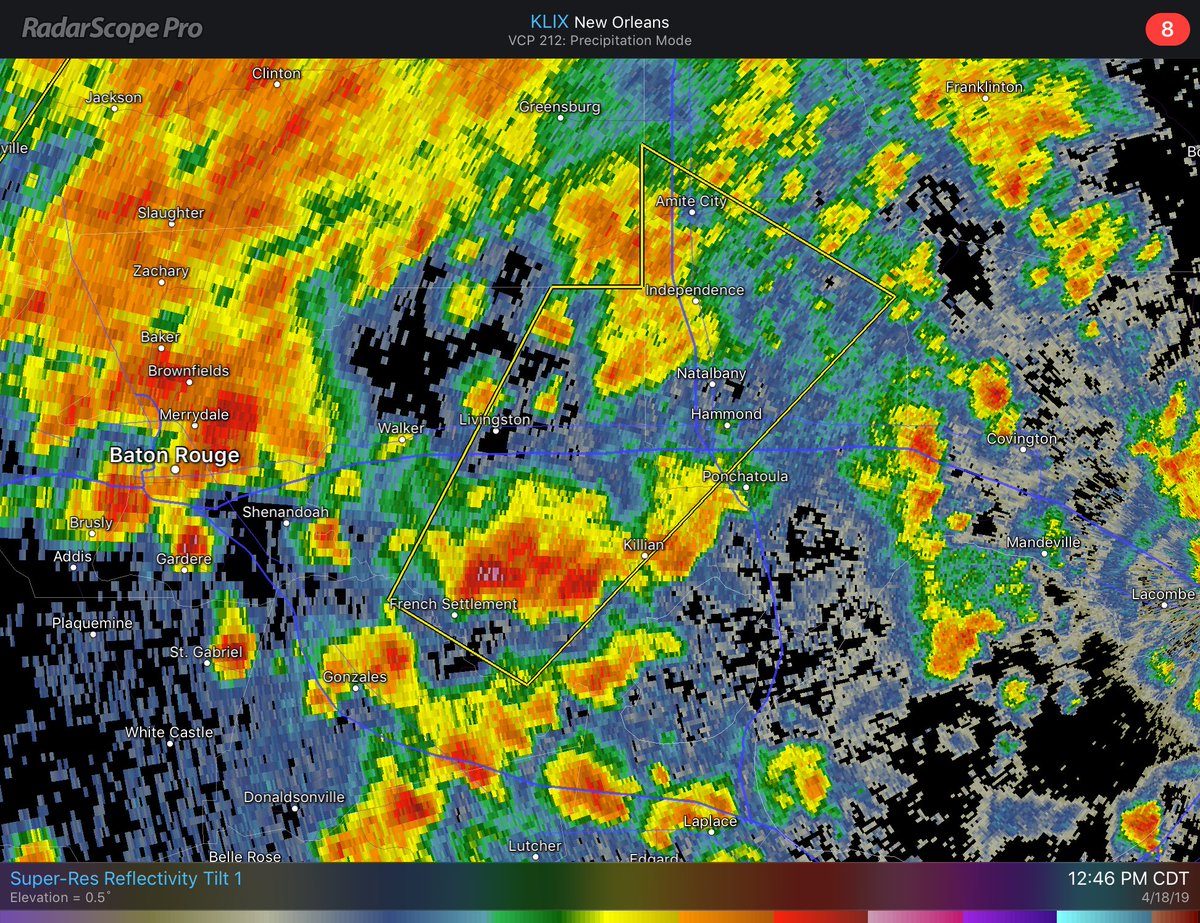
hail is being reported with this warned storm.
I just discovered "Hydrometeor classification" and it is now my favorite radar product because "hydrometeor" is an awesome word. It was definitely showing hail between the split and the bridge. Did anyone from around there see hail? I'm wondering how good this algorithm really is.
Posted on 4/18/19 at 12:48 pm to Duke
 :nana:
Posted on 4/18/19 at 12:49 pm to GumboPot

Posted on 4/18/19 at 12:49 pm to SATNIGHTS
pissin rain now on goodwood
ETA: anddd it stopped
ETA: anddd it stopped
This post was edited on 4/18/19 at 12:54 pm
Posted on 4/18/19 at 12:51 pm to GumboPot
quote:
Atalanta has zero snow equipment so an inch or two and the city comes to a stand still. When I lived there if snow was in the forecast I made sure I left work an hour before the precipitation moved in to get home.
we all remember from the winter vortex in 2014
Posted on 4/18/19 at 12:51 pm to TigerstuckinMS
quote:
I just discovered "Hydrometeor classification" and it is now my favorite radar product because "hydrometeor" is an awesome word. It was definitely showing hail between the split and the bridge. Did anyone from around there see hail? I'm wondering how good this algorithm really is.
The algorithm is good enough for what it does. It takes several radar products and combines them to determine the type of precipitation at the particular tilt level. It isn't always what you will see on the ground cause it's reading at whatever height that tilt is at the time, so the farther you are from the radar site, the higher it's reading. Also in the event of winter weather it doesn't take into account refreezing so you may be seeing sleet, when it's showing rain. Typically the hybrind performs better in winter weather, but in severe weather, like today, I would say it's a wash between the two as they aren't totally accurate to ground truth, but an identifier of what precip could happen.
Posted on 4/18/19 at 12:52 pm to rt3
quote:
NWS New Orleans @NWSNewOrleans
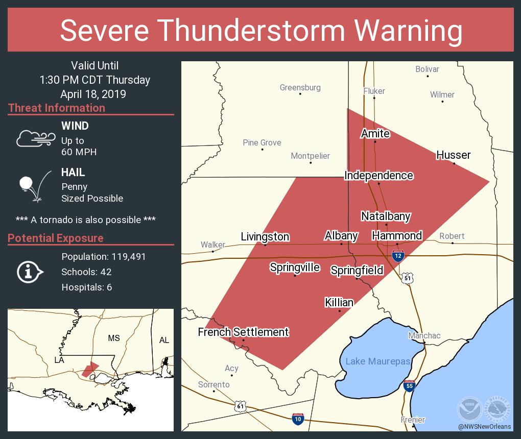
12:50pm: Damaging winds and small hail with this warned storm. A tornado could possibly develop.
Posted on 4/18/19 at 12:55 pm to GEAUXmedic
quote:
The algorithm is good enough for what it does. It takes several radar products and combines them to determine the type of precipitation at the particular tilt level. It isn't always what you will see on the ground cause it's reading at whatever height that tilt is at the time, so the farther you are from the radar site, the higher it's reading. Also in the event of winter weather it doesn't take into account refreezing so you may be seeing sleet, when it's showing rain. Typically the hybrind performs better in winter weather, but in severe weather, like today, I would say it's a wash between the two as they aren't totally accurate to ground truth, but an identifier of what precip could happen.
Cool. I'm guessing that the radar beam out of Slidell is a few thousand feet over Baton Rouge, even at the lowest tilt.
Posted on 4/18/19 at 12:55 pm to NorthEndZone
looks like BR is done until the big line of rain gets here
Posted on 4/18/19 at 12:57 pm to rt3
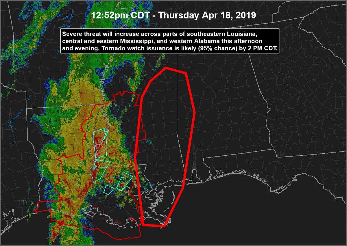
Just took a walk about outside and the clouds are moving at a pretty decent clip toward the N/NW. Low level jet has definitely picked up. We're getting into the window for severe stuff now for the BR -> River Parishes -> Northshore now.
Most concern though is the northern sections. Felicianas. Northern Tangipahoa.
Most concern though is the northern sections. Felicianas. Northern Tangipahoa.
Posted on 4/18/19 at 12:57 pm to GEAUXmedic
I'm sitting on my front porch uptown nola and hearing the monkeys at the zoo a few hundred feet away going nuts right now. What's it like in areas between BR and NOLA right now?
Posted on 4/18/19 at 12:58 pm to GumboPot
quote:
Just curious, what is the reasoning behind this? Differential energy in the form of temperature, humidity...?
Because during this round of storms this is where the most serious weather will be. Guessing stronger storms coming from Gulf versus the north...

This post was edited on 4/18/19 at 12:59 pm
Posted on 4/18/19 at 12:58 pm to Duke
Posted on 4/18/19 at 12:58 pm to Duke
Looks like the cells have moved out of the BR area now. Are you talking more about the line coming later?
Posted on 4/18/19 at 12:58 pm to Duke
quote:
Just took a walk about outside and the clouds are moving at a pretty decent clip toward the N/NW. Low level jet has definitely picked up. We're getting into the window for severe stuff now for the BR -> River Parishes -> Northshore now.
Most concern though is the northern sections. Felicianas.

Posted on 4/18/19 at 1:00 pm to ellishughtiger
quote:
I'm sitting on my front porch uptown nola and hearing the monkeys at the zoo a few hundred feet away going nuts right now. What's it like in areas between BR and NOLA right now?
Meet me at Henry’s in 15

 Page 43 of 69



Popular

Back to top
 Follow TigerDroppings for LSU Football News