- My Forums
- Tiger Rant
- LSU Recruiting
- SEC Rant
- Saints Talk
- Pelicans Talk
- More Sports Board
- Coaching Changes
- Fantasy Sports
- Golf Board
- Soccer Board
- O-T Lounge
- Tech Board
- Home/Garden Board
- Outdoor Board
- Health/Fitness Board
- Movie/TV Board
- Book Board
- Music Board
- Political Talk
- Money Talk
- Fark Board
- Gaming Board
- Travel Board
- Food/Drink Board
- Ticket Exchange
- TD Help Board
Customize My Forums- View All Forums
- Show Left Links
- Topic Sort Options
- Trending Topics
- Recent Topics
- Active Topics
Started By
Message
 3
3

Posted on 9/12/20 at 6:14 pm to TypoKnig
Doubt enough to make any real impact. Looks headed east.
Posted on 9/12/20 at 6:19 pm to TypoKnig
If this current track verifies, track and intensity, New Orleans metro will see a little rain.
A mere 50 miles west as the crow flies and it's a whole other ballgame.
A mere 50 miles west as the crow flies and it's a whole other ballgame.
This post was edited on 9/12/20 at 6:22 pm
Posted on 9/12/20 at 6:19 pm to 3oliv3
I’m from River Ridge. Only time I can ever remember it flooding is the May flood of 95’.
ETA: Wikipedia says that was 10-20” of rain but closer you are to the river the better.
ETA: Wikipedia says that was 10-20” of rain but closer you are to the river the better.
This post was edited on 9/12/20 at 6:21 pm

Posted on 9/12/20 at 6:23 pm to 3oliv3
quote:
Has River Ridge ever flooded due to a hurricane/massive rain event like this? I’m within spitting distance of Langensteins. Just moved here and have no idea if it’s high or low ground other than that it’s levee protected zone X so we weren’t required for flood insurance but we got it anyway.
Your area and along Sauve didn't flood during the May 1995 18" biblical rainfall event. Further down Jeff towards Harahan on levee side the lower elevation streets had some flooding.
I lived near you at the time and the torrential rainfall and constant lightning was awesome and frightening at the same time. It was the hardest most intense rainfall I've ever seen, including hurricanes.
Posted on 9/12/20 at 6:23 pm to BruceJender

Slight western shift for the latest HWRF run
Posted on 9/12/20 at 6:23 pm to NorthEndZone
Calling Duke or Rds...
What do you make of this HWRF run? Obviously not good if it were to verify.

What do you make of this HWRF run? Obviously not good if it were to verify.
Posted on 9/12/20 at 6:24 pm to BruceJender
Screw that new HWRF run

Posted on 9/12/20 at 6:25 pm to lsugolfredman
That’s terrible. Simple as that. Not what I wanna see
Posted on 9/12/20 at 6:25 pm to lsuman25
Yeah that would be a worse wind event than K was for NOLA metro.

Posted on 9/12/20 at 6:26 pm to NorthEndZone
Yeah frick all that noise. It's going from just going to the inlaws to really having to get the hell out of here quickly
Posted on 9/12/20 at 6:28 pm to NorthEndZone
It's weaker than 12z. 

Yes, that's an extremely bad spot for a landfall.
Would think the north turn would have started by this point judging the 18z GFS for the same time. The strength is the high end of the potential. Signal here is for a healthy strengthening phase starting Monday and running through mid day Tuesday.
Didn't do anything to really change the thinking at this point though.
Posted on 9/12/20 at 6:29 pm to NorthEndZone
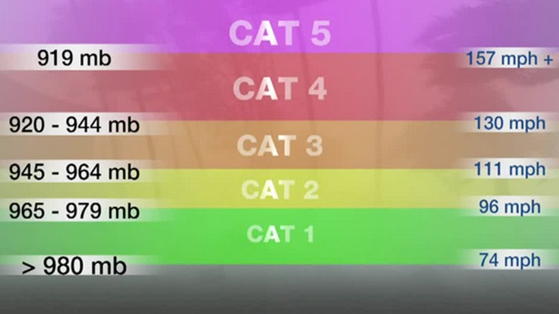
That would be Category 3 territory right up the arse of New Orleans. Worst case scenario
This post was edited on 9/12/20 at 6:30 pm
Posted on 9/12/20 at 6:31 pm to PUB
You're going to shite your pants if that thing shift about 50 miles west

Posted on 9/12/20 at 6:31 pm to MrLSU
quote:
the arse of New Orleans.
Can’t imagine a worse smell
Posted on 9/12/20 at 6:31 pm to MrLSU

HWRF clearly sniffing a stronger ridge to its north. Rainfall would be serious problem without a means to escape north.
Posted on 9/12/20 at 6:32 pm to lsugolfredman
quote:
Slight western shift for the latest HWRF run
So you're taking one run and going with it?

Never mind, cherry picking all the worst case scenarios..
This post was edited on 9/12/20 at 6:34 pm
Posted on 9/12/20 at 6:32 pm to Duke
quote:
Didn't do anything to really change the thinking at this point though.
Thanks for the feedback. At least it is ~60 hours from that possibility. Hopefully recon flights tomorrow will gather good info for the models to zero-in on the track.
I guess now we will all be up until midnight to see if it repeats
This post was edited on 9/12/20 at 6:34 pm

Posted on 9/12/20 at 6:32 pm to TDsngumbo
Posted on 9/12/20 at 6:33 pm to Hangover Haven
quote:
So you're taking one run and going with it?
Did I say that? Its an important run in the scheme of things

 Page 31 of 298

Popular
Back to top