- My Forums
- Tiger Rant
- LSU Recruiting
- SEC Rant
- Saints Talk
- Pelicans Talk
- More Sports Board
- Fantasy Sports
- Golf Board
- Soccer Board
- O-T Lounge
- Tech Board
- Home/Garden Board
- Outdoor Board
- Health/Fitness Board
- Movie/TV Board
- Book Board
- Music Board
- Political Talk
- Money Talk
- Fark Board
- Gaming Board
- Travel Board
- Food/Drink Board
- Ticket Exchange
- TD Help Board
Customize My Forums- View All Forums
- Show Left Links
- Topic Sort Options
- Trending Topics
- Recent Topics
- Active Topics
Started By
Message
re: Remnants of Arthur - Avoyelles Parish Ongoing Flash Flood Emergency
Posted on 6/10/26 at 9:50 am to NOSTRODAMUS
Posted on 6/10/26 at 9:50 am to NOSTRODAMUS
The gulf is plenty warm enough for a Hurricane right now. This year with El Nino, probably our best bet for a hurricane will be in June and July when they usually form in the Gulf.
The shear in the Atlantic (where hurricanes usually form in the late Summer and Fall will help us a lot in Aug, Sept., and Oct.
The shear in the gulf is not going to be as strong as it is in the Atlantic.
I think I watch too much Weather programs.
The shear in the Atlantic (where hurricanes usually form in the late Summer and Fall will help us a lot in Aug, Sept., and Oct.
The shear in the gulf is not going to be as strong as it is in the Atlantic.
I think I watch too much Weather programs.
 1
1

Posted on 6/10/26 at 9:51 am to rds dc
aw shite
ive been dreading this post

ive been dreading this post
Posted on 6/10/26 at 9:54 am to hillcountrytigah
Time to run the generator

Posted on 6/10/26 at 10:08 am to TigerDCC11
quote:
I think I watch too much Weather programs
Confirmed - there's a 90% chance this won't develop.
Posted on 6/14/26 at 2:45 pm to rds dc
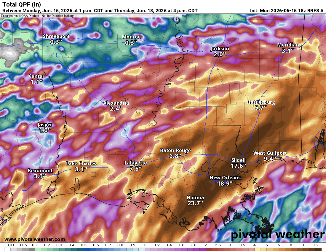
NHC up to 30%. A tropical low will form, but it will be entangled with an old frontal boundary. This will probably keep it from getting a name, but it will bring rain to SE Texas and Louisiana. The 12z Euro has some 20"+ totals offshore from Houston.

Posted on 6/14/26 at 2:48 pm to rds dc
Wake me up when its designated a PTC.
Posted on 6/15/26 at 12:41 pm to rds dc
Tropical Weather Outlook
NWS National Hurricane Center Miami FL
200 PM EDT Mon Jun 15 2026
For the North Atlantic...Caribbean Sea and the Gulf of America:
Northwestern Gulf of America:
A trough of low pressure located over northeastern Mexico is
producing a large area of disorganized showers and thunderstorms.
Development is not expected during the next day or so while the
trough remains inland. However, the system could re-emerge over the
northwestern Gulf of America late Tuesday or Wednesday, and
environmental conditions there are marginally conducive for the
formation of a short-lived tropical storm on Wednesday into
Thursday.
Regardless of tropical cyclone formation, interests across southern
and eastern Texas and portions of Louisiana and Mississippi should
prepare for periods of intense rainfall over the next several days
which could produce widespread, life-threatening flash, urban, and
river flooding. Gusty winds and coastal flooding are also possible
along portions of the northwestern Gulf Coast, and Tropical Storm
Watches or Warnings could be required on Tuesday. Additional
information on this system can be found in products issued by your
local National Weather Service Forecast Office or NHC Key Messages.
* Formation chance through 48 hours...medium...40 percent.
* Formation chance through 7 days...medium...50 percent.
$$
Forecaster Blake
Posted on 6/15/26 at 1:10 pm to rds dc
quote:
NHC up to 30%. A tropical low will form, but it will be entangled with an old frontal boundary. This will probably keep it from getting a name, but it will bring rain to SE Texas and Louisiana. The 12z Euro has some 20"+ totals offshore from Houston.
I can tell you that there rainfall numbers are already getting blow away for coastal MS. Biloxi/D'iberville area already had 4+ inches of rain this morning. We got almost 4" of rain just between 4AM and 8AM and I was slightly north of certain areas that got 6-8" during that same time period.
I think cumulative through Wednesday they were only forecasting 3-5 inches in my neck of the woods
Also kinda dumb they are going to name this. The effects will still be the same...except for insurance

Posted on 6/15/26 at 1:39 pm to rds dc
So the cherry has been popped for Hurricane season... Considering my Homeowners only went up a little over 100 bucks.. We should have a light season...

Posted on 6/15/26 at 3:21 pm to Athis
Posted on 6/15/26 at 3:24 pm to trussthetruzz
i can confirm tropical rain in covington la.
Posted on 6/15/26 at 3:24 pm to trussthetruzz
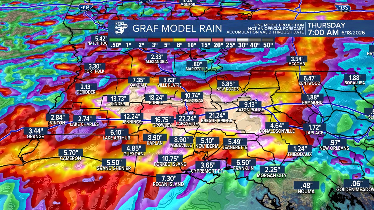
Lafayette getting 22 inches of rain is not good.
Posted on 6/15/26 at 3:34 pm to 4LSU2
quote:
Lafayette getting 22 inches of rain is not good.
going to be lots of gators floating around in town, can't wait for the pictures

Posted on 6/15/26 at 3:36 pm to 4LSU2
quote:
Lafayette getting 22 inches of rain is not good.
Apt analysis
Posted on 6/15/26 at 3:37 pm to trussthetruzz
This type of thing only happens when I sell my side by side and am undecided on which new one to get....

Posted on 6/15/26 at 4:03 pm to 4LSU2
Reminds me of 2016....
Yikes
Yikes

Posted on 6/15/26 at 4:25 pm to Chad504boy
quote:
Chad504boy
yep that one needs to be shared just like the i10 one with the shark

Posted on 6/15/26 at 4:49 pm to trussthetruzz
Perillo loves his graf fear mongering
Posted on 6/15/26 at 4:54 pm to Cosmo

 Page 2 of 28

Popular
Back to top