- My Forums
- Tiger Rant
- LSU Recruiting
- SEC Rant
- Saints Talk
- Pelicans Talk
- More Sports Board
- Fantasy Sports
- Golf Board
- Soccer Board
- O-T Lounge
- Tech Board
- Home/Garden Board
- Outdoor Board
- Health/Fitness Board
- Movie/TV Board
- Book Board
- Music Board
- Political Talk
- Money Talk
- Fark Board
- Gaming Board
- Travel Board
- Food/Drink Board
- Ticket Exchange
- TD Help Board
Customize My Forums- View All Forums
- Show Left Links
- Topic Sort Options
- Trending Topics
- Recent Topics
- Active Topics
Started By
Message
re: Preliminary Ratings: Lacombe Tornado - EF1; NOLA/Arabi Tornado - EF3
Posted on 3/18/22 at 8:51 am to Duke

Posted on 3/18/22 at 8:51 am to Duke
New Convective outlook for today. Enhanced risk has been pushed back to the south. Hopefully the storms this morning have lessened the the threat of a second round of severe storms for central and north Alabama.

 2
2

Posted on 3/18/22 at 8:54 am to Roll Tide Ravens
quote:
Hopefully the storms this morning have lessened the the threat of a second round of severe storms for central and north Alabama.
I hope so. Dont want to destabilize later this evening with the low level shear that will be available.
Posted on 3/18/22 at 9:05 am to LegendInMyMind
quote:
Updated Day 5 and Day 6:
happened to put on a Ryan Hall Y'all video last night before the storms rolled in
talking about the Monday/Tuesday/Wednesday event... he said (and I'm paraphrasing): "If this was late April or May, we'd be looking at multiple days of high risk for tornadoes. Since it's only mid-March might be a saving grace."

Posted on 3/18/22 at 9:18 am to rt3
Sure does look like something rotating on the radar heading towards Beaumont and McLain Ms.
Posted on 3/18/22 at 10:46 am to DeoreDX
Man it's been nasty as hell in the Mobile area. Looks like it's almost done, hopefully.

Posted on 3/18/22 at 11:59 am to Easye921
Quite the line of storms. Mobile looks finished
Posted on 3/18/22 at 12:02 pm to trussthetruzz
for those of us west of the line of current storms... we can now focus on the early week threat for next week
quote:
Meteorologist Nick Mikulas
Last night was most definitely loud, and some areas saw several inches of rain. Unfortunately, where the drought is most severe over south Louisiana, there wasn’t enough rain to put a dent in things. The drought has most certainly been dented in Central Louisiana. In fact, if the drought were a car, it might just have to be totaled. More rain and severe weather is on the way, so let’s jump on in and take a look.
Monday afternoon into Monday night…
Storms are forecast to develop over Texas by late Monday morning. These will move slowly to the east along the leading edge of deeper moisture. Models still vary a bit on timing, but it looks increasingly likely that we will see a round of thunderstorms either late Monday afternoon, or into the overnight. These storms could be severe, with all modes of severe weather possible.
Tuesday…
This still looks like the “main event”, though it looks more likely that we will see at least two waves of severe weather from this system. Storms should once again consolidate over East Texas by Tuesday morning, and slowly translate to the east through the day Tuesday. I think models are under forecasting rainfall totals, as they did with this last event. I’m saying 2-4 inches looks likely, with isolated higher totals. Given the set up, these numbers could be conservative. Severe parameters are high end for the entire event, but seem to peak in the 9:00 AM until 3:00 PM Tuesday timeframe. Again, all modes of severe weather are possible.
Don’t focus exactly on the 30% bullseyes given by SPC. The timing of this all makes it a little wonky here in Central Louisiana when it comes to communicating the risk if you are dealing with cut off times. The SPC outlooks end at 7:00 AM each day, which is kind of right in the middle of our threat. Since severe parameters will remain significant through the event, I’m considering this a level 3/5 enhanced risk for our area, with potential to be increased in later outlooks. There are details that are impossible to forecast until things start happening, but we will start to get some shorter range model data today. That’ll at least give us another couple pieces of data for me to toss in the forecasting hat. I’ll update things as needed, but think it’ll be tomorrow before anything is worth updating. The main threat time is 3:00 PM Monday until 3:00 PM Tuesday. Plan accordingly.


Posted on 3/18/22 at 12:10 pm to rt3
I’m enjoying this weather after storms passed. no clouds, warm, and a constant breeze
Posted on 3/18/22 at 1:00 pm to trussthetruzz
And we were windy with rather brisk temperatures this morning...North Texas. Front came thru dry for us

Posted on 3/18/22 at 1:19 pm to Roll Tide Ravens
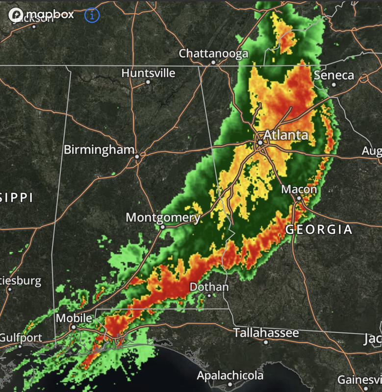
That enhanced area has two tornado warnings on the ground right now. One of them has been tracking straight down I-10 for close to an hour.
Posted on 3/18/22 at 1:35 pm to deeprig9
You Okaloosa county, fl has been getting hammered. Damage reported in Holt, Fl and Atmore, Al.
Posted on 3/18/22 at 2:56 pm to Easye921
Posted on 3/18/22 at 5:09 pm to Duke
are they still thinking that we may have more storms tonight in Central AL? radar seems quiet all over the place, and havent seen any updates since this am.
Posted on 3/18/22 at 5:12 pm to Thracken13
quote:
are they still thinking that we may have more storms tonight in Central AL?
The chances are really diminishing.
Posted on 3/18/22 at 5:14 pm to Duke
Dammit, Duke......this is unacceptable!
Go get your crystal ball tuned up. Don't let it happen again.
ETA: I do thank you for sending that Southerly wind up this way, though. My Purple Martins have finally shown up. They're a week late.
Go get your crystal ball tuned up. Don't let it happen again.
ETA: I do thank you for sending that Southerly wind up this way, though. My Purple Martins have finally shown up. They're a week late.
This post was edited on 3/18/22 at 5:17 pm
Posted on 3/18/22 at 5:58 pm to LegendInMyMind
Waterspout rolling into the Panama City beach area right now.
4th warning between Bay, Okaloosa and Walton Counties in FL this afternoon.
4th warning between Bay, Okaloosa and Walton Counties in FL this afternoon.
Posted on 3/18/22 at 6:05 pm to tide06
quote:
Waterspout rolling into the Panama City beach area right now.
It looks stout too.
Posted on 3/18/22 at 6:14 pm to Duke
There was a decent wake low in NE Georgia earlier on the back side of the line. Phillipe has a couple tweets on it.

Posted on 3/18/22 at 6:15 pm to Duke
quote:
So The Forecast Busted In Louisiana
bernard and fradella on fox 8 nola have been hyper sensitive today because a few people stuck it to them on social media
Posted on 3/18/22 at 6:17 pm to geauxtigers87
quote:
bernard and fradella on fox 8 nola have been hyper sensitive today because a few people stuck it to them on social media
They need to do what Jason Simpson did in North AL, tell them to, "Go lick a doorknob." He said that during Covid times....the horror!

 Page 12 of 94

Popular
Back to top