- My Forums
- Tiger Rant
- LSU Recruiting
- SEC Rant
- Saints Talk
- Pelicans Talk
- More Sports Board
- Coaching Changes
- Fantasy Sports
- Golf Board
- Soccer Board
- O-T Lounge
- Tech Board
- Home/Garden Board
- Outdoor Board
- Health/Fitness Board
- Movie/TV Board
- Book Board
- Music Board
- Political Talk
- Money Talk
- Fark Board
- Gaming Board
- Travel Board
- Food/Drink Board
- Ticket Exchange
- TD Help Board
Customize My Forums- View All Forums
- Show Left Links
- Topic Sort Options
- Trending Topics
- Recent Topics
- Active Topics
Started By
Message
re: Official Harvey Observation Thread
Posted on 8/26/17 at 8:14 pm to jmh5724
Posted on 8/26/17 at 8:14 pm to jmh5724
If it comes back south like they are saying it will be able to pull moisture.
The question I have is was anybody expecting the ENE movement we are seeing now? The weaker it becomes and further from the coast it moves it will have trouble brings tons of rain into Houston
The question I have is was anybody expecting the ENE movement we are seeing now? The weaker it becomes and further from the coast it moves it will have trouble brings tons of rain into Houston
 1
1


Posted on 8/26/17 at 8:15 pm to TexasTiger
Tornados in /near Jersey Village moving North
be aware people
be aware people

Posted on 8/26/17 at 8:17 pm to OWLFAN86
i'm woke
Posted on 8/26/17 at 8:18 pm to jmh5724
quote:
With this storm just sitting over land for the next 5 days will it eventually run itself dry or is it still sucking up moisture from the gulf?
The winds are pulling air from the gulf into Texas. As long as it's sucking, the moisture will be available.
quote:
The question I have is was anybody expecting the ENE movement we are seeing now?
I mean, the motion is going to be a little wonky with nothing really to guide it. The Euro does pull it back over water for a little bit, but with nothing to really pull it NE it just wonders back into Texas until it finds an opening north next weekend.
The models are probably going to jump around a bit too. They don't handle it well when there's nothing to move the system.
This post was edited on 8/26/17 at 8:22 pm
Posted on 8/26/17 at 8:20 pm to List Eater
quote:if it gets bad , do you need a place to stay
i'm woke
cause Dwag has a extra room and makes breakfast
Posted on 8/26/17 at 8:27 pm to Duke
Duke got any links to any updated gdf or euro models? IDK shite about them other than those are the ones most talked about.
Posted on 8/26/17 at 8:30 pm to Duke
Is it going to maintain circulation through the week? Seems like it would eventually just break up into clusters
Posted on 8/26/17 at 8:32 pm to tiger91
LINK
GFS and ECMWF are the two you'd want.
I suspect rds or one of the other TD storm team members will post images as they run as well.
GFS runs four times a day. Euro runs twice.
Now to the question of the storm breaking up. Yes, it will lose organization but the low pressure will remain for a long time and slowly transition to a cold core low. The flow is still counterclockwise though, even if much weaker. So it'll still be pulling in moisture off the gulf.
This post was edited on 8/26/17 at 8:36 pm
Posted on 8/26/17 at 8:34 pm to Duke
thanks.

Posted on 8/26/17 at 8:37 pm to tiger91
Current movement is ENE.
Isn't this early for this movement?
Isn't this early for this movement?
This post was edited on 8/26/17 at 8:39 pm
Posted on 8/26/17 at 8:42 pm to udtiger
Ok, it's getting real in the JV area. May go live here in a bit
Posted on 8/26/17 at 8:43 pm to rds dc
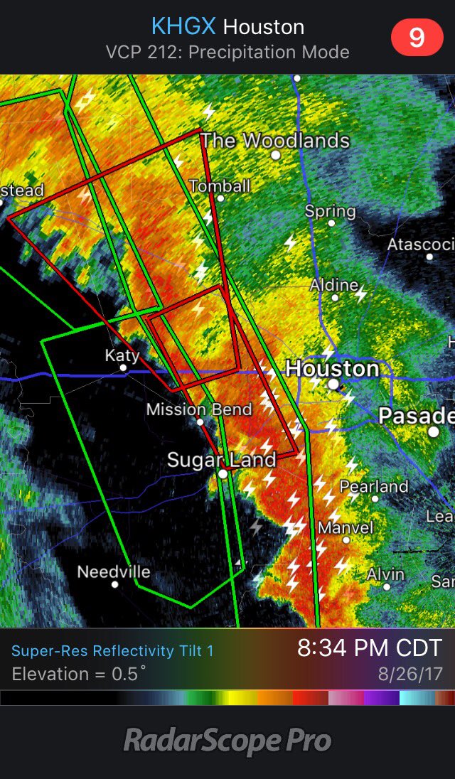
This band moving into Houston is producing rainfall rates between 3-5" per hour and almost every cell is capable of producing tornadoes.

Posted on 8/26/17 at 8:45 pm to List Eater
There's another suspect rotation to the SE of the two current warnings. Heading generally toward the heart of downtown Houston.
Posted on 8/26/17 at 8:47 pm to Duke
Finally a little relief here in Katy after being slammed for the past hour
Posted on 8/26/17 at 8:48 pm to rds dc
Expect to see the red circles grow across the area as the evening goes on.
Posted on 8/26/17 at 8:48 pm to Duke
quote:
GFS
What's that hurricane in the Atlantic in mid September?
Posted on 8/26/17 at 8:50 pm to East Coast Band
A phantom spin up for now. The GFS loves to do that shite that far out. We'll see if it's a trend or if other models pick it up, but that's for later days.
Posted on 8/26/17 at 8:50 pm to rds dc
Cell just really got started where I live .
How long till this moves out and are they expecting more later tonight ?
How long till this moves out and are they expecting more later tonight ?
Posted on 8/26/17 at 8:51 pm to RummelTiger
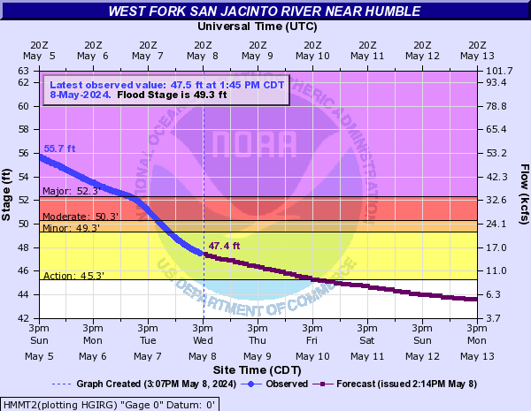
If you live near, or know someone who lives near the West Fork of the San Jacinto River in Humble, be aware that the river is rising to near flood stage.
Right now, it is forecast to crest slightly above the crest of April 2016.
((1) 67.30 ft on 10/18/1994
(2) 63.20 ft on 05/31/1929
(3) 62.80 ft on 09/14/2008
(4) 62.20 ft on 11/26/1940
(5) 61.90 ft on 05/29/2016
(6) 60.10 ft on 11/15/1998
(7) 57.80 ft on 05/07/1935
(8) 57.29 ft on 04/20/2016
Several subdivisions are close to beginning to flood.
55.2 Major lowland flooding continues with up to 6 inches of water is over the 800 block Hamblen Road adjacent to the Kingwood Cove Country Club Golf Course with many homes in the Bellau Woods and Treasure Cove subdivision are flooded.
54.4 Major lowland flooding continues with homes along Riverview Drive in River Ridge subdivision upstream of the gauge begin to flood.
53.3 Major lowland flooding continues with water is in homes on Lake Lane West and Southshore Drive in the Bellau Woods subdivision and Homes in the Treasure Cove subdivision and along Aqua Vista Drive begin flooding.
52.3 Major lowland flooding begins as homes on Lake Lane West and Southshore Drive in the Belleau Woods subdivision begin flooding. Roads into the Treasure Cove subdivision are inundated and homes along Aqua Vista Drive threatened. Water is in many homes on Lake Point Drive in the Northshore subdivision.
51.5 Moderate lowland flooding continues with up to one foot of water is over the road at the intersection of Bellau Wodd and Riviera and many homes in the Northshore subdivision are flooded.
50.3 Moderate lowland flooding begins as homes on Lake Point Drive in the Northshore subdivision begin flooding and roads in the Bellaeu Woods subdivision are inundated.
Posted on 8/26/17 at 9:00 pm to NorthEndZone
The GFS for the next 7 days effectively suggest Harvey isn't going anywhere for a week.


 Page 23 of 38

Popular
Back to top