- My Forums
- Tiger Rant
- LSU Recruiting
- SEC Rant
- Saints Talk
- Pelicans Talk
- More Sports Board
- Coaching Changes
- Fantasy Sports
- Golf Board
- Soccer Board
- O-T Lounge
- Tech Board
- Home/Garden Board
- Outdoor Board
- Health/Fitness Board
- Movie/TV Board
- Book Board
- Music Board
- Political Talk
- Money Talk
- Fark Board
- Gaming Board
- Travel Board
- Food/Drink Board
- Ticket Exchange
- TD Help Board
Customize My Forums- View All Forums
- Show Left Links
- Topic Sort Options
- Trending Topics
- Recent Topics
- Active Topics
Started By
Message
re: Official Harvey Observation Thread
Posted on 8/26/17 at 9:40 am to NorthEndZone

Posted on 8/26/17 at 9:40 am to NorthEndZone
Just watched a bunch Snapchats from that area and it doesnt look too bad, hopefully his house is still there.
 2
2

Posted on 8/26/17 at 9:46 am to GREENHEAD22
His house meaning who??
Posted on 8/26/17 at 9:46 am to rds dc
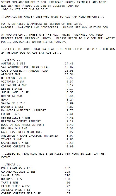
Looks like Harvey will end up in the Top 15, there is little doubt that if Harvey would have organized the inner core 12 hrs sooner that it would have made a run at the Top 5.


Posted on 8/26/17 at 9:47 am to GREENHEAD22
Been getting pounded up in the humble/kingwood area. Looks like the outer band that's been on too of us is moving east but could easily shift back.
Posted on 8/26/17 at 9:49 am to slackster
Goes to show that Harvey wasn't sustaining it was rapidly intensifying those hours before landfall
Posted on 8/26/17 at 9:50 am to Cool Hand Luke
quote:
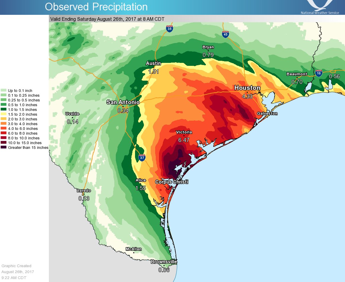
Where are you getting these totals? I just checked and it says around 2.5 inches.
I believe that Victoria report is really the general Victoria area.
The NE part of Houston has seen up to 4 inches in the last 3 hours.
SW of Victoria has seen over 14 inches in the last 12 hours.
Last 12 hour totals:

LINK
Posted on 8/26/17 at 9:52 am to rds dc
This looks really bad for the Houston area with an intense feeder band training cells in off the Gulf.


Posted on 8/26/17 at 9:53 am to rds dc
Do you think the storm will really sit over Houston until Friday? 

Posted on 8/26/17 at 9:53 am to slackster
quote:
I believe that Victoria report is really the general Victoria area.
It's Victoria center. NWS has been pulling the obs there, probably due to a couple spurious reports a few days ago. The data looks fine to me now so they might verify it in post storm analysis.
new advisory still has a Hurricane.. moving north at 2 kts
Posted on 8/26/17 at 9:55 am to rds dc
Totals so far, seeing some reports that NWS can't confirm the really high reports from around Victoria (not shown) and thinks they are possibly bad data.

Posted on 8/26/17 at 10:00 am to Hulkklogan
quote:
Models have no damn clue where it's going to go
That picture is the definition of a clusterfrick.
Posted on 8/26/17 at 10:11 am to rds dc
He got his shite in gear just in time to frick things up
Posted on 8/26/17 at 10:11 am to LSUGrad9295
We are getting some rain, not really any wind right now. It fit windy last night around midnight but not a lot of rain at that time.
I stopped watching the weather Channel because it seems like they know about as much as I do.
I stopped watching the weather Channel because it seems like they know about as much as I do.
Posted on 8/26/17 at 10:12 am to rds dc
It's hard to put faith in any models given the extreme nature of this setup, but the insane rainfall total signal continues with the 12z 3K NAM showing 36"+ for Houston over the next 60 hrs. It looks like 42" for the Woodlands...

Posted on 8/26/17 at 10:14 am to rds dc
Should we still be concerned about this thing coming back towards the east?
Posted on 8/26/17 at 10:14 am to rds dc
Rds that forecast is for when?
Posted on 8/26/17 at 10:17 am to Mr. Hangover
From the NHC discussion at 10am
I think this sums it up pretty well.
quote:
The only agreement among the track guidance is that Harvey is certainly not going anywhere fast.
I think this sums it up pretty well.
Posted on 8/26/17 at 10:18 am to tiger91
quote:
that forecast is for when?
That is a 48hr projection, so from this morning to Monday morning.
Posted on 8/26/17 at 10:19 am to baytiger
quote:Damn. Pretty crazy since the immediate Victoria area doesn't seem to have received the same totals.
It's Victoria center. NWS has been pulling the obs there, probably due to a couple spurious reports a few days ago. The data looks fine to me now so they might verify it in post storm analysis.

 Page 15 of 38

Popular
Back to top