- My Forums
- Tiger Rant
- LSU Recruiting
- SEC Rant
- Saints Talk
- Pelicans Talk
- More Sports Board
- Coaching Changes
- Fantasy Sports
- Golf Board
- Soccer Board
- O-T Lounge
- Tech Board
- Home/Garden Board
- Outdoor Board
- Health/Fitness Board
- Movie/TV Board
- Book Board
- Music Board
- Political Talk
- Money Talk
- Fark Board
- Gaming Board
- Travel Board
- Food/Drink Board
- Ticket Exchange
- TD Help Board
Customize My Forums- View All Forums
- Show Left Links
- Topic Sort Options
- Trending Topics
- Recent Topics
- Active Topics
Started By
Message
re: Official Harvey Observation Thread
Posted on 8/26/17 at 9:02 am to TigerTatorTots
Posted on 8/26/17 at 9:02 am to TigerTatorTots
Tots, search "whatever river" stages in Google and it ought to bring you to the page. Once there, you can look upstream and downstream as well.
I'll link to all river gauges I post as well.
I'll link to all river gauges I post as well.
 0
0

Posted on 8/26/17 at 9:03 am to baytiger
If I should be posting this in the other thread just let me know and I'll delete but one of my dumbass buddies has a wedding in Houston and wants to go there from Dallas today
I keep showing him these rainfall projections and explaining what a mess it will likely be but he won't listen
Worst part is he's normally a pretty smart guy
ETA: finally got him to cancel
I keep showing him these rainfall projections and explaining what a mess it will likely be but he won't listen
Worst part is he's normally a pretty smart guy
ETA: finally got him to cancel
This post was edited on 8/26/17 at 10:09 am

Posted on 8/26/17 at 9:05 am to Wishnitwas1998
I've got the weather report from here in Houston:


Posted on 8/26/17 at 9:07 am to RummelTiger
The fella whose parents lived in Rockport; has he checked in? I'm hoping they decided to leave in time.
This post was edited on 8/26/17 at 9:08 am

Posted on 8/26/17 at 9:10 am to TheFonz

Models have no damn clue where it's going to go
Posted on 8/26/17 at 9:12 am to rds dc
Just the old 15-50" scale...


Posted on 8/26/17 at 9:12 am to Hulkklogan
No shite. Those things are ridic. Good news is Chita is working Saturday this week 
Posted on 8/26/17 at 9:22 am to rds dc
Posted on 8/26/17 at 9:23 am to Chad504boy
quote:
What's the big deal about noting "lightning in the eye wall"?
I asked a good question in the smart thread w zero response, can someone talk about this?
This post was edited on 8/26/17 at 9:25 am
Posted on 8/26/17 at 9:24 am to TheFonz
quote:
The fella whose parents lived in Rockport; has he checked in? I'm hoping they decided to leave in time.
Not sure if this is him but
from TxWadingFool in the other thread:
quote:
I'm fine, thanks for asking. My place most likely is gone, all the pictures so far that I've seen are from the Rockport/Fulton area and are terrible, our place is in Lamar which took the worst of the eye wall. Just heard from a family that rode it out down the road from our place and their house came apart around them and is gone, no details on how they survived yet.
damn, they were lucky
Posted on 8/26/17 at 9:26 am to RummelTiger
Harvey has a major disaster declaration. Stafford Act programs are approved to allow FEMA to distribute Individual Assistance it should be updated here
https://www.fema.gov/disaster/4332
Once you and your loved ones are safe
You can apply for assistance in 3 ways:
- Online at https://www.disasterassistance.gov/
- OR By Caling 800-621-3362 (711 or Video Relay Service). If you use TTY, call 800-462-758
- OR By visiting a Disaster Recovery Center once they are set up. You can find them here https://asd.fema.gov/inter/locator/home.htm
Remember FEMA's mission is not to make you "whole again" or make it like the disaster never happened for you. Their first goal is to return you to safe, sanitary and functional living conditions.
IMPORTANT:
Apply for aid if you were affected in even the smallest manner. The applications give FEMA invaluable data that help FEMA and other state, local and federal agencies understand the scope of the disaster. This in turn helps your community receive the assistance that it needs.
If FEMA directs you to apply for a SBA loan for more assistance, apply for it! You do not have to accept the loan. The application is a step in the aid process. Once you have made that application you then become eligible for more disaster grant money.
Most of all, hang in there and don't give up!
This post was edited on 8/27/17 at 8:37 am
Posted on 8/26/17 at 9:27 am to rds dc
NCAR ensembles are maxed out over a large area.

Posted on 8/26/17 at 9:27 am to Chad504boy
quote:
I asked a good question in the smart thread w zero response, can someone talk about this?
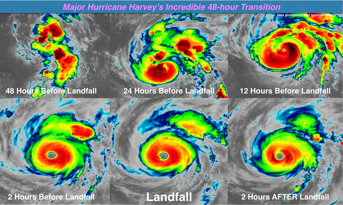
There is a belief that lightning in the inner core is a sign of intensification.
quote:
Typhoon Haiyan was already one of the strongest tropical storms on record. Now it has another claim to fame.
Analysis of satellite data has revealed that the storm, which hit the Philippines in 2013, hosted a spectacular lightning show in its innermost core – something not seen in recorded storms of similar intensity.
Haiyan was found to have lightning at its core for 49 per cent of its life between 3 and 11 November that year, when it killed some 6300 people and wreaked huge damage to property and infrastructure. By comparison, hurricanes Rita and Katrina had lightning at their cores for just 5 and 3 per cent of their existence, respectively.
“Lightning is usually infrequent in the inner core [of a storm],” says Wenjuan Zhang at the Chinese Academy of Meteorological Sciences in Beijing. “Normally, lightning is found at the periphery of storms.”
Rita and Katrina had very little, so it's not really a requirement for an intense storm.
Posted on 8/26/17 at 9:29 am to baytiger
Where are you getting these totals? I just checked and it says around 2.5 inches.
Posted on 8/26/17 at 9:30 am to slackster
HRRR setup in Houston looks bad:

Nearly 16 inches over the next 18 hours.
Nearly 16 inches over the next 18 hours.
Posted on 8/26/17 at 9:31 am to slackster
Katrina wasn't intensifying per se but it was already intense, could that be part of difference?

Posted on 8/26/17 at 9:34 am to Chad504boy
quote:Lightning in the eyewall is pretty rare for a sustaining or weakening tropical cyclone. It usually is a signal for ongoing intensification.quote:
What's the big deal about noting "lightning in the eye wall"?
I asked a good question in the smart thread w zero response, can someone talk about this?

Posted on 8/26/17 at 9:35 am to baytiger
College Station update: 9:34 am
Significant rain last hr bumped our total up to 4.7 inches since landfall....I dumped my gauge.
Significant rain last hr bumped our total up to 4.7 inches since landfall....I dumped my gauge.
Posted on 8/26/17 at 9:37 am to Chad504boy
quote:
Katrina wasn't intensifying per se but it was already intense, could that be part of difference?
Bay tiger's response indicates that lightning in a sustaining storm is pretty rare.

 Page 14 of 38

Popular
Back to top