- My Forums
- Tiger Rant
- LSU Recruiting
- SEC Rant
- Saints Talk
- Pelicans Talk
- More Sports Board
- Coaching Changes
- Fantasy Sports
- Golf Board
- Soccer Board
- O-T Lounge
- Tech Board
- Home/Garden Board
- Outdoor Board
- Health/Fitness Board
- Movie/TV Board
- Book Board
- Music Board
- Political Talk
- Money Talk
- Fark Board
- Gaming Board
- Travel Board
- Food/Drink Board
- Ticket Exchange
- TD Help Board
Customize My Forums- View All Forums
- Show Left Links
- Topic Sort Options
- Trending Topics
- Recent Topics
- Active Topics
Started By
Message
re: Morganza Spillway may or may not open for a 3rd time -- lack of clear info from ACoE
Posted on 2/22/19 at 11:20 pm to White Roach
Posted on 2/22/19 at 11:20 pm to White Roach
quote:
Allowing the river to periodically make major course shifts isn't practical these days
Bingo.
 1
1

Posted on 2/22/19 at 11:29 pm to White Roach
quote:
I understand all of that, but if a 1927 type flood fricked up the economy in 1927, what do you think it would do now? Allowing the river to periodically make major course shifts isn't practical these days.
It is only the very tail that shifts and periodical is really a misnomer as it normally occurs every few hundred years, the solution was not building things in those locations but politicians made promises so we are where we are.
The question is do we continue to double down on a bad bet or start making reasonable plans for what is inevitable.
Read some of James Eads works, the river was his baby and he is likely the smartest man this country has ever produced, certainly the most gifted engineer.
Posted on 2/22/19 at 11:34 pm to Chuker
quote:I can't stop reading this comment for some reason. Funny troll.
My cousin who works with a guy thats wife is in charge of life jackets in South La
You gotta be from way down the bayou to be appointed for that position. Too much responsibility for just any regular life jacket specialist to take care of the whole southern state.
Posted on 2/22/19 at 11:44 pm to The Baker
quote:
The corp will not let it fail.
quote:
what can they do?
In 2011, the levee at Duncan Point, which is close to Farr Park on River Road was identified as the weakest point along the entire Mississippi. COE had serious concerns about a breech there. Residents in Riverbend subdivision and along Brightside were advised to be prepared to move to the attic/rooftop. No way to notify anyone in that area if breech were to occur.
After the River went down, the entire levee in that area was shored up. River Road rises there about 3.5 feet due to all the dirt and materials brought in.
Posted on 2/22/19 at 11:47 pm to Nephropidae
The thread on the OB has the formal title listed as something like Executive Administrator of Bouyant Attire. I broke out laughing when I read it. All I know is that next time young kids are going out on the boat, I'm appointing someone as Executive Administrator of Bouyant Attire to help fit PFDs on the children.
Posted on 2/23/19 at 12:12 am to cave canem
quote:
The MS river historically always had multiple outlets to the sea which relieved flooding and caused land building along the coast. The state of affairs today and the necessity for ever higher levees and control structures was created by the ACE, they are the problem not the solution.
While true, if your scenario played out that way NOLA is a smaller footprint, with almost not industrial corridor on the Miss.
USACE made a bargain-more industry for higher future risk.
Posted on 2/23/19 at 12:14 am to haricot rouge
quote:
In 2011, the levee at Duncan Point, which is close to Farr Park on River Road was identified as the weakest point along the entire Mississippi. COE had serious concerns about a breech there. Residents in Riverbend subdivision and along Brightside were advised to be prepared to move to the attic/rooftop. No way to notify anyone in that area if breech were to occur.
After the River went down, the entire levee in that area was shored up. River Road rises there about 3.5 feet due to all the dirt and materials brought in.
Dirt and shoring can't stop piping and sand boils.
Eventually its going to go somewhere, and no one wants to be last one not dancing.
Posted on 2/23/19 at 12:17 am to NYNolaguy1
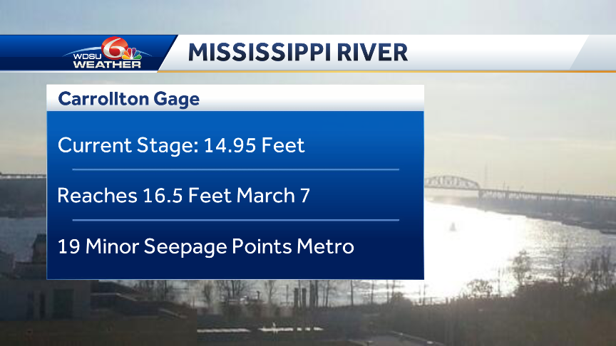
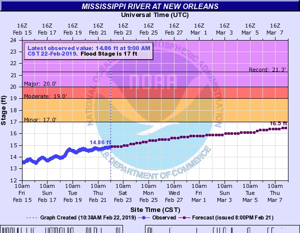


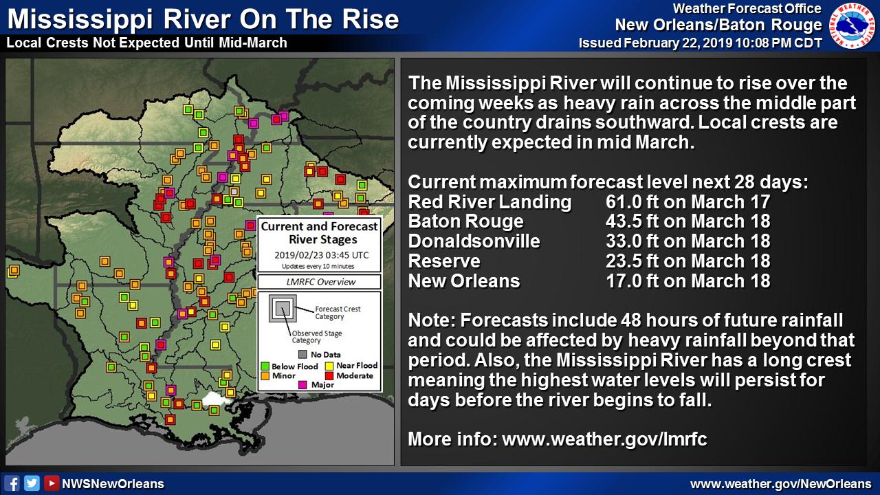
Latest from NOAA the Miss River will be at 17 feet on March 18.
Posted on 2/23/19 at 12:19 am to PhiTiger1764
quote:
At this point, year 2019, man has the ability to prevent it from ever happening. The Corps will build an entire new structure to replace the ORCS when they need to.
USACE can guarantee it won't fail at ORCS.
But what about a little upriver or downriver? What about the miles and miles of levees that have historically been mismanaged, underdesigned, poorly constructed, and run by political cronies?
You cant protect everywhere all the time. It's going to go sooner or later.
Posted on 2/23/19 at 12:33 am to MrLSU
The river is forecasted to reach flood stage on 3/18 and that's AFTER the spillway having been opened for approximately 3 weeks. I wonder where it would be without the spillway to bypass some flow.
Posted on 2/23/19 at 4:44 am to NYNolaguy1
Its been awhile since I read about the 73 flood, but that structure almost failed then. There was grout pumped down there as a lot of the structure was left hanging on its deeply exposed pilings, everything they tried during the high water event failed. You got to wonder if that repair was less than optimum.
Also, there is something like a 40 foot drop to the Atchafalaya in that area that would make the shift unstoppable once it starts.
The corps had determined that by the 1990's the Mississippi would jump channels if nothing was done to hold it back.
Also, there is something like a 40 foot drop to the Atchafalaya in that area that would make the shift unstoppable once it starts.
The corps had determined that by the 1990's the Mississippi would jump channels if nothing was done to hold it back.
Posted on 2/23/19 at 5:42 am to White Roach
quote:
The river is forecasted to reach flood stage on 3/18 and that's AFTER the spillway having been opened for approximately 3 weeks. I wonder where it would be without the spillway to bypass some flow.
The manipulation goes back much farther than that, the problems started when Capt. Shreve cut off Turnbulls bend and goes from there.
For those who continue to insist that somehow both BR and NO will be cut off if water is allowed to freely flow down the Atchafalaya please take note that the river did exactly that for some 500 years.
Nearly every single flowing body of water between US hwy 49 in MS and US hwy 165 in LA was a dis-tributary of the MS during high water in recent history, we caged it with levees making the monster what it is today.
The levees and structures are not protecting us from higher floods, they are the cause of them
We have spent the last 150 years trying to bend the river to our economic advantage and there will be a price to pay for this.


Posted on 2/23/19 at 8:10 am to NYNolaguy1
Sure but if you add enough sand you can reduce the Head difference

Posted on 2/23/19 at 8:13 am to jimbeam
Reducing head is never a good idea.
Posted on 2/23/19 at 8:17 am to jlntiger
quote:
Every inch of rise in the river is exponentially more flow than before . The river is not in a perfect box. 5 more feet at Vicksburg is significantly more flow than it has now. Getting above 48 ft is a big deal
Got it. The converse of that is that it will take a frick load more water to get it as high as it was in 2011. And the system held then without even fully using Morganza.
Posted on 2/23/19 at 8:21 am to 200MPHCOBRA
quote:
You got to wonder if that repair was less than optimum.
They’ve added an auxillary structure and a hydroelectric outlet since then. That part of the system will be under less strain.
Posted on 2/23/19 at 8:24 am to JudgeHolden
quote:
the system held then without even fully using Morganza.
The problem is the river is shallower on average than it was. What that means is you get less flow per higher river stages. Morganza was intentionally opened prematurely if you only looked at the river flows and ignored river elevation. That has lead some to believe that there are things going on with the river that are not fully understood.
Tldr: if design flood happened today it would be at a higher elevation than originally designed.
Posted on 2/23/19 at 8:25 am to PhiTiger1764
quote:
Therefore, they won’t let it happen.
Who is ‘they?’ And, kind of like Katrina, or 9/11, or Houston flooding, or BR floods of 2026, or California wildfires? All that was unimaginable too.
Posted on 2/23/19 at 8:35 am to NYNolaguy1
quote:
That has lead some to believe that there are things going on with the river that are not fully understood.
No doubt.
Posted on 2/23/19 at 9:08 am to cave canem
Thank you for posting that graph. I’ve driven over the ORCS my whole life, and still feel like I need to stare at a map to understand it.
For those interested, check out the history of the lower Mississippi River. Its course has hopped around south Louisiana over the last 4000 years. Bayou Teche was its original outflow tract to the gulf, followed by Bayou Lafouche. In 1400, the Red flowed parallel with the Mississippi all the way to the gulf.
Our current issues with coastal erosion are 100% due to the levee system. The silt that would ordinarily be pouring into the marsh right now is being diverted out to sea.

 Page 10 of 107

Popular
Back to top