- My Forums
- Tiger Rant
- LSU Recruiting
- SEC Rant
- Saints Talk
- Pelicans Talk
- More Sports Board
- Coaching Changes
- Fantasy Sports
- Golf Board
- Soccer Board
- O-T Lounge
- Tech Board
- Home/Garden Board
- Outdoor Board
- Health/Fitness Board
- Movie/TV Board
- Book Board
- Music Board
- Political Talk
- Money Talk
- Fark Board
- Gaming Board
- Travel Board
- Food/Drink Board
- Ticket Exchange
- TD Help Board
Customize My Forums- View All Forums
- Show Left Links
- Topic Sort Options
- Trending Topics
- Recent Topics
- Active Topics
Started By
Message
 1
1

Posted on 3/14/25 at 2:44 pm to LegendInMyMind
i'm sick and tired of these extreme weather events. jesus.
Posted on 3/14/25 at 2:45 pm to Roll Tide Ravens
quote:
For anyone who might be looking for a public/community storm shelter, this website has an interactive map showing where they are. Just zoom to your area.
You should add that link to your OP.

Posted on 3/14/25 at 2:45 pm to LegendInMyMind
quote:
You should add that link to your OP.
Just did

Posted on 3/14/25 at 2:45 pm to Chad504boy
If only the cows stopped farting them we wouldn't have them anymore
Posted on 3/14/25 at 2:47 pm to AUstar
Hope everyone stays safe!
I just got an email from Congressman Robert Aderholt on being weather aware this weekend. No clue how I got on that mailing list. Here's what it said...
Good afternoon. I know I don't normally email in the middle of the month, but I wanted to just send a reminder about the potential for severe weather this weekend. Large, long-track tornadoes cannot be ruled out.
While there is the threat overnight tonight and into Saturday morning, the biggest potential threat is Saturday afternoon and evening across the entire Fourth Congressional District. So, please be weather aware and have multiple ways to receive warnings.
Posted on 3/14/25 at 2:48 pm to OU Guy
South of Amarillo, Texas on I-27. Already a major 50 car pile up just south of Canyon on I-27 (not my picture)

This post was edited on 3/14/25 at 2:49 pm
Posted on 3/14/25 at 2:51 pm to BoogaBear
quote:
Trying determine what to do. We live in an old house on a crawl space. I don't think that's where we want to be during this event, we're in the 5.
Have to find someone that will take us in with dogs and cats. I say we leave the cats at home and take the dogs.
I would pull up google maps and use the setting that shows structures. Then find anything close thats brick and solid like a school. Have this as an emergency backup plan, and test how long it tales to get to.
And then make sire you have a baseball bat or hammer and if tornado is coming break the glass in door to get inside. This is worst case scenario, hopefully you find a place that takes you all in. But you have to be prepared ahead and test your drive no matter where you go. Including how long it takes to load up family and pets and driving plus getting everyone out and inside.
I’m lucky to have an underground garage tornado shelter. Good luck and stay safe. Advance planning is key.

Posted on 3/14/25 at 2:55 pm to alphaandomega

Posted on 3/14/25 at 2:59 pm to Bobby OG Johnson
Loading Twitter/X Embed...
If tweet fails to load, click here. quote:
DANGEROUS SEVERE THUNDERSTORM/TORNADO OUTBREAK AHEAD: A dangerous outbreak of severe thunderstorms and tornadoes is forecast across a large area beginning late tonight. A dynamic storm system will bring two rounds of severe thunderstorms.
ROUND ONE
*The broad window for the first round of severe thunderstorms will come from around 11:00 tonight through 8:00 a.m. tomorrow.
*SPC has defined an "enhanced risk" (level 3/5) for much of West Alabama for this event, with a "slight risk" (level 2/5) as far east and south as Scottsboro, Prattville, and Jackson.
*Highest risk of severe storms with "round one" will be over the western half of the state, mainly along and west of I-65. The severe threat is much lower over the eastern counties, where the air will be more stable.
*Where storms develop, they will be capable of producing hail and damaging winds. A few tornadoes are possible as well, mainly over West Alabama.
ROUND TWO
*This is the "main event"; the window is from 12 noon tomorrow through 3:00 a.m. Sunday.
*A rare "high risk" (level 5/5) has been defined for parts of Alabama and Mississippi, including Tuscaloosa and Birmingham. The rest of the state is in a level 4/5 risk. FYI the last high risk issued for a part of Alabama was on March 25, 2021.
*Storms will be capable of producing large hail, damaging winds, and tornadoes. A few violent, long track tornadoes are possible. This is a dangerous setup.
*A flash flood watch has been issued for the northern third of Alabama where the heaviest rain is expected, and a wind advisory has been issued for the northern 2/3 of the state. Gradient winds will gust to 30/35 mph at times.
KEY MESSAGES
*I don't use strong wording often, but in this case it is needed. The threat is real, and the event is a dangerous situation for all of Alabama and most of the southern U.S. The goal is no loss of life, and no serious injuries; we all have a big role to play.
*It is critical that you hear warnings. An outdoor siren is never, ever a primary way of hearing warnings. The "siren mentality" has killed more people than anything else during tornado events in Alabama. The baseline for every home and business is a NOAA Weather Radio; unfortunately many retailers have sold out of them due to the high demand this week. On your phone, be sure emergency alerts are enabled in notification settings... this is the tone you hear for tornado warnings and amber alerts. Have the free ABC 33/40 weather app installed. Turn the sleep/do not disturb modes OFF for the weekend so you will receive notifications at night.
*In your safe place, have helmets for everyone, including adults. Use a car seat for infants. Most serious injuries in tornadoes involve blunt force trauma above the shoulders. Wearing hard shoes is also a good idea. Have a portable air horn for everyone; they can alert first responders to your location if you are injured.
*If you live in a mobile home, know the location of the nearest shelter, or business open 24/7 that can serve as a shelter. Have transportation arranged so you can get there quickly. You cannot stay in a mobile home if you are in a tornado warning polygon.
*A car is a death trap during a tornado. If you are driving and get a tornado warning notification, pull off as quickly as possible and go into a gas station, fast food restaurant, or any other business that can serve as a shelter. Do not drive into a tornado warning polygon.
*You can be a hero. If you are reading this, you pay attention to weather. Let friends and family members today know this is a dangerous threat. During the event, if you have a friend or loved one in a tornado warning polygon, call or text them to let them know of the immediate danger. You can play a huge role in saving lives.
*Subscribe to the James Spann and ABC 33/40 YouTube channels so you can watch our live coverage. During the event itself all of my attention is focused on the live coverage. I simply am not able to respond to the hundreds of requests for individual briefings during a severe weather outbreak.
*Get the warnings, have a good plan, and we get through this together.
This post was edited on 3/14/25 at 3:04 pm
Posted on 3/14/25 at 3:00 pm to AHM21
Posted on 3/14/25 at 3:02 pm to Roll Tide Ravens
historic tornado outbreak on the Ides of March?
Coincidence?
Coincidence?

Posted on 3/14/25 at 3:03 pm to AHM21
"Put your kids in carseats in the basement" is definitely an attention getter
Posted on 3/14/25 at 3:04 pm to Bobby OG Johnson
Posted on 3/14/25 at 3:05 pm to DVinBR
Here's am update from about an hour ago from a meteorologist I followed while living in Central Louisiana (Ellick, Pineville area)
quote:
SPC has just upgraded parts of Mississippi and Alabama to a high risk of severe weather on Saturday. The high risk is rarely used, and hasn’t been since May of 2024. We’ve only had 5 instances of a high risk since 2020 including tomorrow’s high risk. Each of the last 3 high risks saw at least one EF4 tornado, and it wouldn’t surprise me at all to see multiple, strong, long tracked tornadoes tomorrow. Heck, it wouldn’t surprise me if we saw multiple long tracked tornadoes across the country today. So yes, it’s going to be a rough couple of days, though I still think the worst of this stays to our north and east. That being said, my thought process has changed a bit on the local impact.
Let’s start with the Friday threat. The HRRR model, and some other high resolution guidance is becoming more insistent that we will see a severe threat in our area this afternoon. The 4:00-9:00 PM timeframe looks like our best chance to see severe storms develop. All modes of severe weather will be possible with any storms that develop. While I’m still uncertain on how many storms may pop, I do know that there will be the potential for significant severe weather with any cells that do fire up. Unfortunately, today’s threat has trended in the wrong direction, and I now think we will have severe weather in the area due to agreement among the short range models that there will be storms. This is especially true for the northern half of Central Louisiana.
Saturday is going to be a nasty day across the Deep South, and while the most intense threat will be to our east, we still stand a chance to see severe weather in the morning and early afternoon. Any storm that develops could quickly become severe, with all modes of severe weather possible. This will quickly exit to the east of our area by around 2:00 PM, but even a brief threat, with severe parameters like this is a dangerous threat. The further west you go in our area, the better your chance to see no severe weather on Saturday. I think west of Highway 165 has a much lower chance than places like St. Landry, Avoyelles, Catahoula, and Concordia Parish. Once this system exits our area, we will see an outbreak of tornadoes across southeast Louisiana, Mississippi, Alabama, and Tennessee. This could be a day those areas will be talking about for a long while.
As many of you know, I am out of town, and going a bit crazy that I’m not there. I’ll say it a million times, I have the best back up in the world in Tom Konvicka, and you are in the best hands for any local severe coverage. All we can do now is be ready to seek shelter, and pray this system ends up underachieving in a big way. I’ll be watching the cameras if we have severe weather in our area later today so I can keep those pointed in the right direction. We will update things as needed.
Alexandria Emergency Hospital
cenlaweather.com
This post was edited on 3/14/25 at 3:06 pm
Posted on 3/14/25 at 3:07 pm to Bobby OG Johnson
80mph is Cat 1 hurricane
Posted on 3/14/25 at 3:08 pm to OU Guy
Loading Twitter/X Embed...
If tweet fails to load, click here. 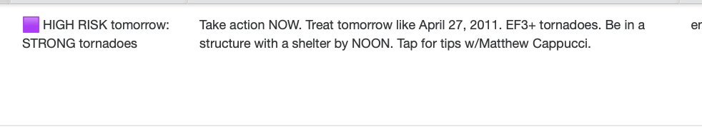
This post was edited on 3/14/25 at 3:10 pm
Posted on 3/14/25 at 3:09 pm to AHM21

Posted on 3/14/25 at 3:17 pm to slinger1317
Go play somewhere else. You have zero respect for Mother Nature.
Posted on 3/14/25 at 3:17 pm to LegendInMyMind
NWS Norman is not tracking storms today, but wildfires.
Loading Twitter/X Embed...
If tweet fails to load, click here.
 Page 9 of 88

Popular
Back to top