- My Forums
- Tiger Rant
- LSU Recruiting
- SEC Rant
- Saints Talk
- Pelicans Talk
- More Sports Board
- Fantasy Sports
- Golf Board
- Soccer Board
- O-T Lounge
- Tech Board
- Home/Garden Board
- Outdoor Board
- Health/Fitness Board
- Movie/TV Board
- Book Board
- Music Board
- Political Talk
- Money Talk
- Fark Board
- Gaming Board
- Travel Board
- Food/Drink Board
- Ticket Exchange
- TD Help Board
Customize My Forums- View All Forums
- Show Left Links
- Topic Sort Options
- Trending Topics
- Recent Topics
- Active Topics
Started By
Message
re: Major Severe Weather Outbreak: March 14-16, 2025
Posted on 3/15/25 at 9:27 pm to Roll Tide Ravens
Posted on 3/15/25 at 9:27 pm to Roll Tide Ravens
It was a pretty clean hook and rotation.
Some nastiness rolling into Mobile but that should be the end of the threat tonight for them
Some nastiness rolling into Mobile but that should be the end of the threat tonight for them
 0
0

Posted on 3/15/25 at 9:27 pm to Roll Tide Ravens
quote:
Spann says they have unconfirmed reports of severe damage near Maplesville.
I think it hit the paper mill south of town.
ETA: I think it may have been too far south to have hit it.
This post was edited on 3/15/25 at 9:35 pm

Posted on 3/15/25 at 9:29 pm to LegendInMyMind
SIAP, but some of the footage coming out of Tylertown, MS looks like something from WWI. 
Loading Twitter/X Embed...
If tweet fails to load, click here.Posted on 3/15/25 at 9:31 pm to Roll Tide Ravens
This 2 day severe weather event has been discussed for almost all week and it appears to have lived up to its hype. Numerous tornadoes (some long path), lots of damage/ destruction, flash flooding, lives lost, etc. I’m glad it’s about to begin its exit from AL. Good luck GA, SC.
Posted on 3/15/25 at 9:33 pm to George Dickel
Yup. Anxiously waiting until about 4 AM.
Mattress in the hallway, helmet ready and sleeping on couch with weather radio in arms reach.
Mattress in the hallway, helmet ready and sleeping on couch with weather radio in arms reach.

Posted on 3/15/25 at 9:39 pm to shutterspeed
God Bless those people
Posted on 3/15/25 at 9:39 pm to Sizzle_DAWG
Tower hit by the Bakersfield, MO tornado last night
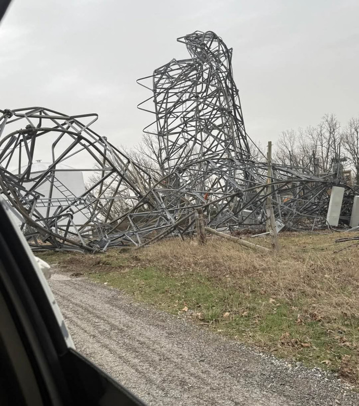
Posted on 3/15/25 at 9:42 pm to SidewalkTiger
Heard it was an EF3
Posted on 3/15/25 at 9:51 pm to SidewalkTiger
That tower collapse is at least EF3 strength, if I remember the damage indicators correctly.

Posted on 3/15/25 at 9:53 pm to Thracken13
quote:
Thx man. The wife and i almost bought a historic home there. Really didn't want anything to happen to it

Posted on 3/15/25 at 9:54 pm to Sizzle_DAWG
Spann says they have reliable reports of a fatality in Plantersville, AL. That was the storm that went close to Maplesville.
Posted on 3/15/25 at 9:59 pm to Roll Tide Ravens
Damn :(

Posted on 3/15/25 at 10:01 pm to Roll Tide Ravens
Watching ATL airport and it looks like they're getting the last bank of flights out right now (10-11pm) before the storms hit. Few inbound flights that look pretty delayed from earlier in the day trying to get in before the storms hit, but doesn't look like a total mess on the tarmac. And it appears some East/West flight routes are opening up rather than sending everything way north or way south to get around the line of storms
This post was edited on 3/15/25 at 10:04 pm
Posted on 3/15/25 at 10:02 pm to shutterspeed
That’s awful.
Has rolling fork in Mississippi ever started to recover from was it 2023??? It looked like this.
This post was edited on 3/15/25 at 10:04 pm
Posted on 3/15/25 at 10:06 pm to Sizzle_DAWG
Based on what I've seen so far, I think these will be the "major" tornadoes from the outbreak. Feel free to add any I missed.
Bakersfield, MO - EF3+ (my guess)
Rolla, MO - EF3+ (my guess)
Cave City, AR - Very high end EF-3, nearly EF-4 (165 MPH) - NWS Little Rock preliminary
Poplar Bluff, MO - EF-3 (138 MPH) -NWS Paducah preliminary
Diaz, AR, Jonesboro AR, etc - EF3+ (my guess)
Tylertown, MS - EF3+ (my guess)
Maybe that Gordo, AL storm as well
We're at 12 dead in MO and 3 in Arkansas, last I heard
This post was edited on 3/15/25 at 10:15 pm
Posted on 3/15/25 at 10:07 pm to LegendInMyMind
quote:
That tower collapse is at least EF3 strength, if I remember the damage indicators correctly
Possibly, there was a tower collapse in Seymour, MO also but a much smaller tower.
Think that will be a high end EF2.
This post was edited on 3/15/25 at 10:12 pm
Posted on 3/15/25 at 10:20 pm to SidewalkTiger
The line of storms with the bowing segment headed north of Atlanta is stout. It produced a 77mph gust back in Anniston, AL and looks healthier now.
Posted on 3/15/25 at 10:24 pm to SidewalkTiger
Yea, that’s tough.
Think the overall death toll is in the 30’s. Terrible.
Think the overall death toll is in the 30’s. Terrible.
Posted on 3/15/25 at 10:25 pm to LegendInMyMind
Yup. That’s the main concern and the meat of the system coming into GA.
Hunker down Dawgs
Hunker down Dawgs
This post was edited on 3/15/25 at 10:26 pm

Posted on 3/15/25 at 10:26 pm to Sizzle_DAWG
ATL Airport Live Cam
ETA: Anybody know which direction this is facing?
ETA: Anybody know which direction this is facing?
This post was edited on 3/15/25 at 10:30 pm

 Page 77 of 88

Popular
Back to top