- My Forums
- Tiger Rant
- LSU Recruiting
- SEC Rant
- Saints Talk
- Pelicans Talk
- More Sports Board
- Coaching Changes
- Fantasy Sports
- Golf Board
- Soccer Board
- O-T Lounge
- Tech Board
- Home/Garden Board
- Outdoor Board
- Health/Fitness Board
- Movie/TV Board
- Book Board
- Music Board
- Political Talk
- Money Talk
- Fark Board
- Gaming Board
- Travel Board
- Food/Drink Board
- Ticket Exchange
- TD Help Board
Customize My Forums- View All Forums
- Show Left Links
- Topic Sort Options
- Trending Topics
- Recent Topics
- Active Topics
Started By
Message
re: Major Severe Weather Outbreak: March 14-16, 2025
Posted on 3/14/25 at 9:03 pm to RollTide1987
Posted on 3/14/25 at 9:03 pm to RollTide1987
One headed for Defiance, Mo looks nasty it’s wrapped up tight
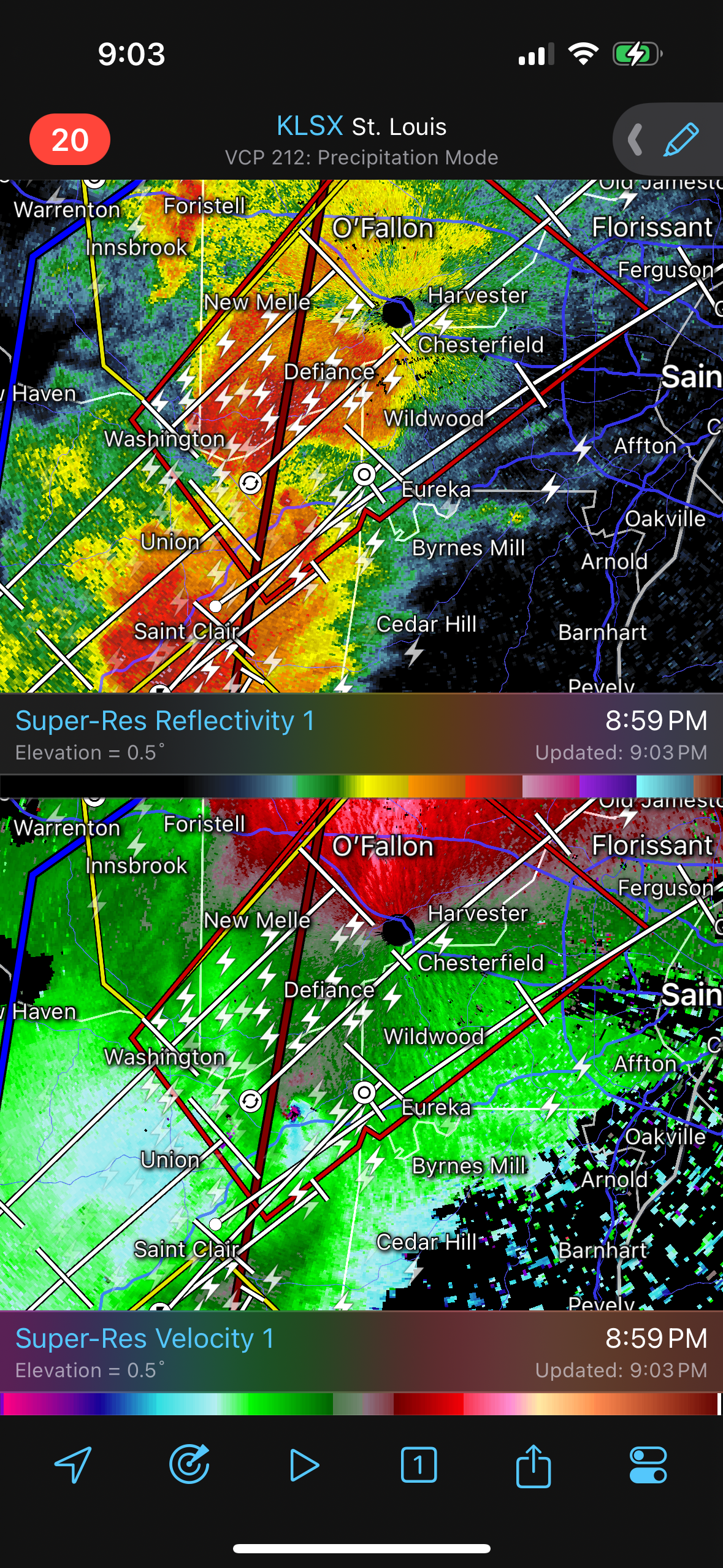
This post was edited on 3/14/25 at 9:05 pm
 1
1

Posted on 3/14/25 at 9:14 pm to deltaland
Posted on 3/14/25 at 9:15 pm to LegendInMyMind
I'd like to see that radar loop

Posted on 3/14/25 at 9:19 pm to Chad504boy
Posted on 3/14/25 at 9:20 pm to Bobby OG Johnson
Posted on 3/14/25 at 9:20 pm to East Coast Band
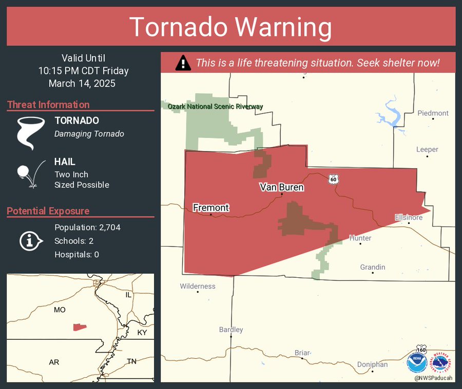
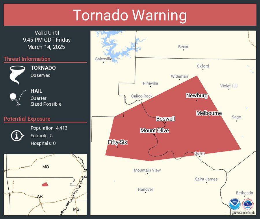
The one near Mount Olive, AR is probably on the ground.
ETA: It is on the ground.
ETA: It is on the ground.
This post was edited on 3/14/25 at 9:21 pm
Posted on 3/14/25 at 9:21 pm to LegendInMyMind
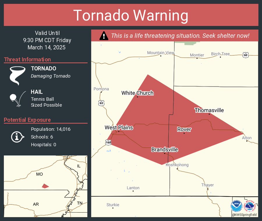
One east of West Plains, Mo is getting scary
Posted on 3/14/25 at 9:25 pm to Bobby OG Johnson
Posted on 3/14/25 at 9:25 pm to Steve Rogers
Posted on 3/14/25 at 9:26 pm to Bobby OG Johnson

Posted on 3/14/25 at 9:26 pm to deltaland
quote:Already seen 2 or 3 in the last few hours
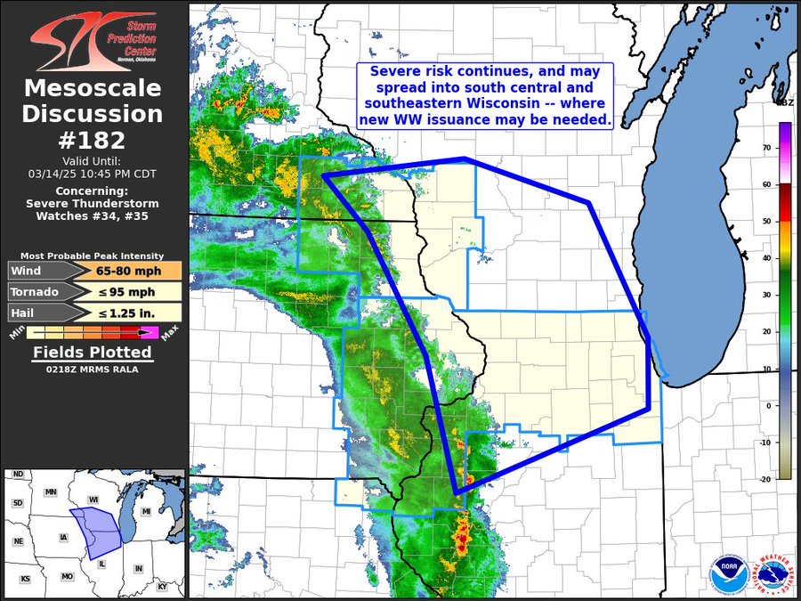
I expect several PDS warnings over the next 32 hours
Set the O/U at 5
Posted on 3/14/25 at 9:27 pm to Bobby OG Johnson
Posted on 3/14/25 at 9:31 pm to LegendInMyMind
quote:I wonder how that's going to affect the timing of Round 2
LegendInMyMind
Posted on 3/14/25 at 9:32 pm to Iron Lion
So New Orleans still getting severe weather tomorrow? All I can find are updated day one outlooks
Posted on 3/14/25 at 9:33 pm to Iron Lion
quote:
I wonder how that's going to affect the timing of Round 2
It is hard to say until we see it play out. It could dampen the atmosphere a little. I wouldn't bank on it it, but it is possible.
Posted on 3/14/25 at 9:33 pm to Bobby OG Johnson
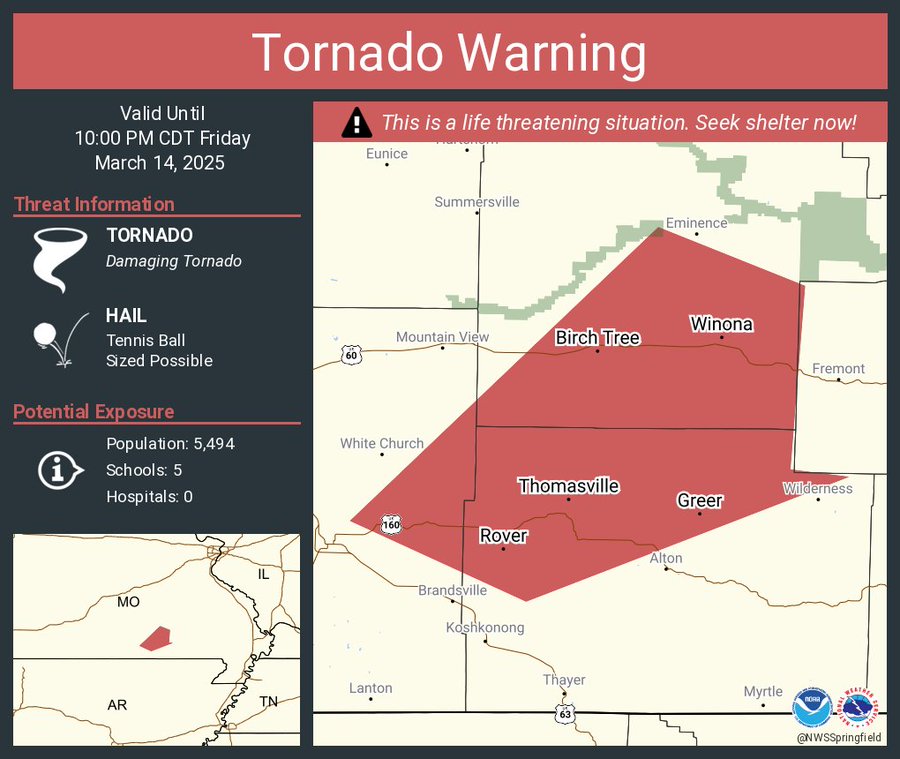
931 PM CDT Fri Mar 14 2025
...A TORNADO WARNING REMAINS IN EFFECT UNTIL 1000 PM CDT FOR SOUTH
CENTRAL SHANNON AND NORTHERN OREGON COUNTIES...
At 930 PM CDT, a confirmed large and extremely dangerous tornado was
located 9 miles northwest of Alton, or 17 miles southeast of Mountain
View, moving northeast at 40 mph.
This is a PARTICULARLY DANGEROUS SITUATION. TAKE COVER NOW!
HAZARD...Damaging tornado.
SOURCE...Radar confirmed tornado.
IMPACT...You are in a life-threatening situation. Flying debris may
be deadly to those caught without shelter. Mobile homes
will be destroyed. Considerable damage to homes,
businesses, and vehicles is likely and complete destruction
is possible.
Locations impacted include...
Thomasville, Greer, and Winona.

Posted on 3/14/25 at 9:33 pm to LegendInMyMind
I wonder if this is gonna suck some of the energy out of the air for round 2
Posted on 3/14/25 at 9:34 pm to CE Tiger
quote:
So New Orleans still getting severe weather tomorrow? All I can find are updated day one outlooks
Day 2 should update to Day 1 around 1am.
Posted on 3/14/25 at 9:34 pm to Hateradedrink
That's what I'm hoping. I'm pretty much in the bullseye tomorrow.

 Page 17 of 88

Popular
Back to top