- My Forums
- Tiger Rant
- LSU Recruiting
- SEC Rant
- Saints Talk
- Pelicans Talk
- More Sports Board
- Fantasy Sports
- Golf Board
- Soccer Board
- O-T Lounge
- Tech Board
- Home/Garden Board
- Outdoor Board
- Health/Fitness Board
- Movie/TV Board
- Book Board
- Music Board
- Political Talk
- Money Talk
- Fark Board
- Gaming Board
- Travel Board
- Food/Drink Board
- Ticket Exchange
- TD Help Board
Customize My Forums- View All Forums
- Show Left Links
- Topic Sort Options
- Trending Topics
- Recent Topics
- Active Topics
Started By
Message
 2
2


Posted on 3/10/16 at 9:23 pm to rds dc
What is the word on the Dogwood levee?
I heard it was about to bust but its hearsay.
I heard it was about to bust but its hearsay.

Posted on 3/10/16 at 9:24 pm to rds dc
Pretty intense cells rolling up to Baton Rouge now.

Posted on 3/10/16 at 9:26 pm to LaBR4
How are things between Marksville and Alex? Gotta drive up from Avoyelles tomorrow

Posted on 3/10/16 at 9:28 pm to LaBR4
quote:
intense cells moving into Baton Rouge
Yep...looking at radar, the train is lining up on BR.
Posted on 3/10/16 at 9:29 pm to S
I think the people with the weather machine are sparing Nola.
Posted on 3/10/16 at 9:29 pm to udtiger
Flash flood warning on the pville/ebr line on Jefferson hwy.
Yikes
Yikes
Posted on 3/10/16 at 9:30 pm to Large Farva
Just got the warning on my phone. Old Jefferson
Posted on 3/10/16 at 9:30 pm to MrSmith
Got the warning too. Near LSU

Posted on 3/10/16 at 9:30 pm to jefforize
Northern Ascension got the warning til 1:30 am
Posted on 3/10/16 at 9:31 pm to udtiger
yeah you're right...It's lining up tonight right through there..Between New Iberia to Morgan City getting hammered too as it moves up to BR
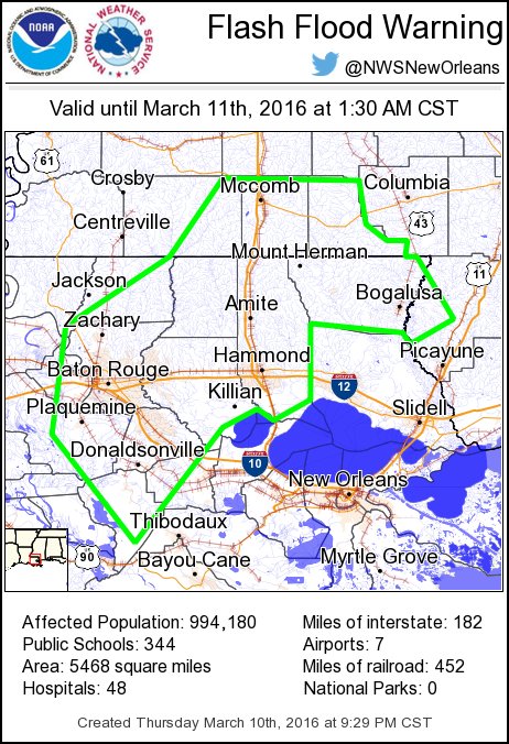
same warning in Baton Rouge, flash flood until 1:30am on the phone
same warning in Baton Rouge, flash flood until 1:30am on the phone
This post was edited on 3/10/16 at 9:34 pm
Posted on 3/10/16 at 9:31 pm to AJN
Think everyone got it
Posted on 3/10/16 at 9:32 pm to LaBR4
flood warning here south of Juban in Denham
Posted on 3/10/16 at 9:33 pm to LaBR4
With 18.97" the official reporting station at Monroe airport exceeded the 1000 yr 2-day total of 18.4"

Posted on 3/10/16 at 9:35 pm to rds dc
Sooo. Last time this happened was 1016
Posted on 3/10/16 at 9:36 pm to rds dc
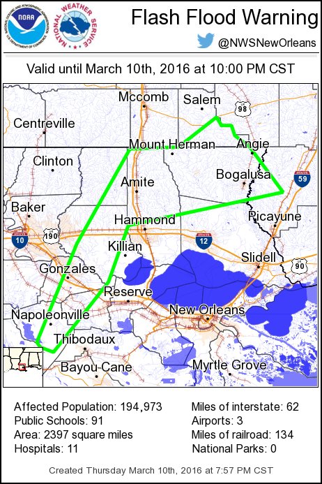
Updated flood warning to include the BR area with another 2-4" possible
Posted on 3/10/16 at 9:36 pm to S
quote:
How are things between Marksville and Alex? Gotta drive up from Avoyelles tomorrow
The future radar indicates that area will get hammered as it moves up starting around Midnight-3 am and beyond...they'll get a pounding too..
This post was edited on 3/10/16 at 9:39 pm
Posted on 3/10/16 at 9:39 pm to Large Farva
quote:
Sooo. Last time this happened was 1016
Let me go down in the basement and dust off the record books
Posted on 3/10/16 at 9:40 pm to rds dc
Posted on 3/10/16 at 9:42 pm to bubbz
quote:
bubbz
Are you going to help Tony Time sandbag?

 Page 49 of 102

Popular
Back to top