- My Forums
- Tiger Rant
- LSU Recruiting
- SEC Rant
- Saints Talk
- Pelicans Talk
- More Sports Board
- Fantasy Sports
- Golf Board
- Soccer Board
- O-T Lounge
- Tech Board
- Home/Garden Board
- Outdoor Board
- Health/Fitness Board
- Movie/TV Board
- Book Board
- Music Board
- Political Talk
- Money Talk
- Fark Board
- Gaming Board
- Travel Board
- Food/Drink Board
- Ticket Exchange
- TD Help Board
Customize My Forums- View All Forums
- Show Left Links
- Topic Sort Options
- Trending Topics
- Recent Topics
- Active Topics
Started By
Message
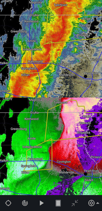
re: Let's Do It Again: Severe Threat 3/30 - Line of Severe Storms leaving SELA. AL in it now
Posted on 3/30/22 at 6:45 pm to Roll Tide Ravens
Posted on 3/30/22 at 6:45 pm to Roll Tide Ravens
I believe it - im on a ridge across from double oak mountain , south of Birmingham and the wind here is screaming.....mary
This post was edited on 3/30/22 at 6:46 pm
 0
0

Posted on 3/30/22 at 6:45 pm to Roll Tide Ravens


Posted on 3/30/22 at 6:45 pm to OchoDedos
quote:
Bruce Katz is scaring the shite out of everyone in WP
Present
Posted on 3/30/22 at 6:47 pm to Shankopotomus
quote:
That’s how Katrina happened, a couple huge false alarms and people let their guards down
And it will happen over amd over and over.
It's science.

Posted on 3/30/22 at 6:48 pm to rt3
I’m assuming downscale is bad?
It sounds like you want something to downscale but then it says from squall to supercell?
It sounds like you want something to downscale but then it says from squall to supercell?
Posted on 3/30/22 at 6:48 pm to tunechi
will the stuff popping in AL around Tuscaloosa sap out the actual line that is still in MS?

Posted on 3/30/22 at 6:48 pm to shawnlsu
Look out Hattiesburg
Posted on 3/30/22 at 6:48 pm to shawnlsu
Looks like all north MS and South western TN tornado warnings have been dropped
Still prepared to be hammered by straight line winds
Still prepared to be hammered by straight line winds
Posted on 3/30/22 at 6:48 pm to Roll Tide Ravens
quote:
New tornado warning for a storm just southwest of Starkville, MS.
Improvements inbound!
I kid, I kid.
Hope everyone stays safe
This post was edited on 3/30/22 at 6:51 pm
Posted on 3/30/22 at 6:48 pm to Nguyener
quote:
I’m assuming downscale is bad?
It sounds like you want something to downscale but then it says from squall to supercell?
downscaling from a line to individual cells could raise the big tornado potential
Posted on 3/30/22 at 6:50 pm to Nguyener
quote:
It sounds like you want something to downscale but then it says from squall to supercell?
Correct, you don’t want the line to break apart and crank up the supercells. That’s what caused the NO tornado last week.
Posted on 3/30/22 at 6:51 pm to LegendInMyMind
quote:
They will likely re-warn that Natalbany storm
The dirty dirty in union county won't have none of that. Y'all on even know.
Posted on 3/30/22 at 6:51 pm to Thracken13
It being a QLCS my guess is no but the main line seems to be transitioning away from being a tornado issue to just being a wind issue, of course that could change
Posted on 3/30/22 at 6:53 pm to Wishnitwas1998
quote:
It being a QLCS my guess is no but the main line seems to be transitioning away from being a tornado issue to just being a wind issue, of course that could change
For your area that's the likely progression.
Down South, we are seeing a transition to a more broken line.
Posted on 3/30/22 at 6:53 pm to LegendInMyMind
Yea I’m bad about that
I should be clear that applies to North MS/southern TN
I should be clear that applies to North MS/southern TN
This post was edited on 3/30/22 at 6:54 pm

Posted on 3/30/22 at 6:54 pm to rt3
Well that's not promising
Posted on 3/30/22 at 6:56 pm to Ingeniero
quote:
Well that's not promising
Looks like the same line as last time. Good thing I love anxiety….
Posted on 3/30/22 at 6:56 pm to Ingeniero
just feel that this could help some people out
you know how an event that is currently evolving is called a "fluid situation"?
weather is literally a "fluid situation" 24/7/365
you know how an event that is currently evolving is called a "fluid situation"?
weather is literally a "fluid situation" 24/7/365
Posted on 3/30/22 at 6:57 pm to LegendInMyMind
Ok. We dont want this line to break because its awful sheary, we have good surface moisture and instability at this point (though less than last week). Those individual cells can better tap the potential of the environment and would be able to updraft from the surface.
In other words, a broken line brings a tornado threat into play.
In other words, a broken line brings a tornado threat into play.
This post was edited on 3/30/22 at 6:58 pm

 Page 62 of 92

Popular
Back to top