- My Forums
- Tiger Rant
- LSU Recruiting
- SEC Rant
- Saints Talk
- Pelicans Talk
- More Sports Board
- Fantasy Sports
- Golf Board
- Soccer Board
- O-T Lounge
- Tech Board
- Home/Garden Board
- Outdoor Board
- Health/Fitness Board
- Movie/TV Board
- Book Board
- Music Board
- Political Talk
- Money Talk
- Fark Board
- Gaming Board
- Travel Board
- Food/Drink Board
- Ticket Exchange
- TD Help Board
Customize My Forums- View All Forums
- Show Left Links
- Topic Sort Options
- Trending Topics
- Recent Topics
- Active Topics
Started By
Message
re: Laura - President Trump visits Lake Charles, Louisiana for Hurricane Response Update
Posted on 8/22/20 at 10:37 am to geauxtigersgirl
Posted on 8/22/20 at 10:37 am to geauxtigersgirl
quote:
Marco has intensified significantly though. I wonder how much effect the wind shear conditions will have on it if Marco continues to strengthen.
Maro is very small and the upper level trough over the Gulf is stout. So this isn't a case were latent heat released by the storm can fracture a PVS, since Marco won't produce enough. The one wild card for Marco is if the UL trough retrogrades faster than modeled and that keeps Marco in the favorable orientation that it is in this morning.
 1
1


Posted on 8/22/20 at 10:37 am to rt3


Posted on 8/22/20 at 10:38 am to rds dc
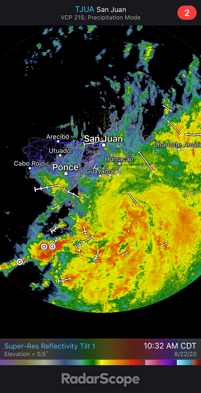
puerto rico radar

Posted on 8/22/20 at 10:38 am to S
That chick looks like she’d get pregnant just by looking at a cock

Posted on 8/22/20 at 10:39 am to Duke
Looks like the 12z GFS initialized with Marco at 1009mb, when in reality it's at 992 per HH... does that make this run pretty much useless?
Posted on 8/22/20 at 10:45 am to rds dc
Considering the trough unknowns, any way Marco could land as a Hurricane?

Posted on 8/22/20 at 10:45 am to The Boat
Truth.
Posted on 8/22/20 at 10:45 am to LSUJuice
Aircraft Position: 20.78°N 85.55°W
Bearing: 45° at 164 kt
Altitude: 1561 gpm
Peak 10-second Wind: 15 kt at 295°
Extrapolated Sea-level Pressure: 1008.3 mb

Bearing: 45° at 164 kt
Altitude: 1561 gpm
Peak 10-second Wind: 15 kt at 295°
Extrapolated Sea-level Pressure: 1008.3 mb
This post was edited on 8/22/20 at 10:48 am

Posted on 8/22/20 at 10:49 am to lsufan4lifeMiles
Gulf Stacked LA fricked

Posted on 8/22/20 at 10:49 am to lsufan4lifeMiles
Want to decipher?

Posted on 8/22/20 at 10:49 am to lsufan4lifeMiles
Meteorologist Nick Mikulas
quote:
Our baffling two Gulf storm scenario continues to unfold and get crazier by the hour. The potential remains for these two systems to interact with one another, or even weirder, be just far enough apart to bring issues from two systems to parts of the area. Track guidance is still quite “interesting” on both, and specific wind and rain impacts are still impossible. But we are about 3 days from the first potential hit, so it is time to trim any suspect limbs, gas up the generator, and make sure any hatches you may have, are battened down. That’s not a definite, this thing is coming here, but a gentle nudge that it might be.
Tropical Storm Marco…
LOCATION...20.9N 85.3W
ABOUT 105 MI...170 KM ENE OF COZUMEL MEXICO
ABOUT 75 MI...120 KM SSW OF THE WESTERN TIP OF CUBA
MAXIMUM SUSTAINED WINDS...65 MPH...100 KM/H
PRESENT MOVEMENT...NNW OR 340 DEGREES AT 12 MPH...19 KM/H
MINIMUM CENTRAL PRESSURE...992 MB...29.30 INCHES
Marco is small, but potent. An eyewall is starting to form, and it appears we could have a hurricane by this afternoon. Marco continues to hang out on the east side of the model track guidance, and as it deepens, should continue to feel deeper steering currents, which, at this point means more north, or northwest motion, as opposed to west northwest. The official forecast makes Marco a category 1 hurricane, that should weaken on approach as wind shear increases. Small storms like Marco tend to have quick fluctuations in strength, as we are seeing this morning. As Marco continues to the northwest, it will encounter increasing shear, but that overall shear pattern will be weakening with time. Basically, it may be moving into an area that had 40 knots of shear yesterday, but has 30 today, and will have 20 tomorrow. I know I’m getting a little too technical there. I’m basically saying the shear will be significant enough to have impacts, but should be in a weakening phase. So if Marco overachieves, and is a stronger hurricane, it will be able to endure this shear a bit better. The new forecast track has areas along I-10 in the cone of uncertainty, which is a slight shift northward. High pressure will be building in across the northeastern Gulf, that “should” shove Marco a bit more to the west on approach to the coast. This high will also be what steers Laura our way. So the same general steering currents will be at play, but the storms will be about 36 hours apart. I’m so sorry I can’t describe this in a simpler way. Every aspect of forecasting is continually changing. That’s the nature of any forecast. In this case, these changes could allow the incredibly unique situation of two landfalling tropical systems, in a two day window, in a small geographic area. Another wrench is that Marco is already much stronger than any model is forecasting, which will have an impact in track guidance down the road.
Tropical storm Laura…
LOCATION...17.8N 66.8W
ABOUT 20 MI...30 KM SW OF PONCE PUERTO RICO
ABOUT 210 MI...335 KM ESE OF SANTO DOMINGO DOMINICAN REPUBLIC
MAXIMUM SUSTAINED WINDS...40 MPH...65 KM/H
PRESENT MOVEMENT...W OR 280 DEGREES AT 18 MPH...30 KM/H
MINIMUM CENTRAL PRESSURE...1006 MB...29.71 INCHES
Laura looks decent on satellite, but closer investigation shows it is still pretty disorganized. I think Laura stays disorganized, as there will be lots of land interaction in the next couple days. Beyond the next couple days, Laura comes out into the Gulf of Mexico with some solid conditions for strengthening. Warm water, light shear, and all that stuff. The general idea is that Laura will be somewhere near the western tip of Cuba by late monday. A building ridge of high pressure will continue to shove Laura to the northwest. As Laura (in theory) strengthens over the Gulf of Mexico, it will start to round the edge of the ridge of high pressure, and move in our general direction. NHC has this landfalling near Vermillion Bay as a category 1 hurricane. Again, don’t focus on the exact path, and honestly, don’t focus on that strength forecast. This could really ramp up quickly if it enters the gulf with the circulation intact. On the other hand, it could be a disheveled mess with all the land it will have to deal with.
This leaves us with the potential of two tropical systems within striking distance in a two day stretch. It looks like Marco could bring local issues by Monday night into Tuesday, and Laura Wednesday night into Thursday. I can’t give specifics yet, but it’s time to prepare as a precautionary measure. I know I always say that I want to see another set of models and all that stuff, but I really think the next 24 hours is key. I think I’ll have a good handle on things by tomorrow, mainly because we will see how models react to a much stronger than forecast Marco. That should give at least some clarity, and hopefully allow me to start nailing down rain and wind impacts if it looks like Marco will be close enough. I’ll update things this evening, or post a quick hit if/when Marco becomes a hurricane.
Posted on 8/22/20 at 10:55 am to Hat Tricks
Newest GFS is going to rock LA on both ends

Posted on 8/22/20 at 10:56 am to lsugolfredman
12z GFS is about to give us a big eastward shift for Marco
Posted on 8/22/20 at 10:57 am to Roll Tide Ravens
Ignore, messed up post.
This post was edited on 8/22/20 at 10:59 am
Posted on 8/22/20 at 10:57 am to Hat Tricks
Marco... 51 kts (58.7 mph) at the surface in the NW eyewall according to 3 different dropsondes
This post was edited on 8/22/20 at 10:58 am
Posted on 8/22/20 at 10:59 am to Roll Tide Ravens
12z GFS for Marco.

12z GFS for Laura.

12z GFS for Laura.
This post was edited on 8/22/20 at 11:00 am
Posted on 8/22/20 at 10:59 am to Roll Tide Ravens
Will you share the next GFS

Posted on 8/22/20 at 10:59 am to Roll Tide Ravens

Posted on 8/22/20 at 11:00 am to Roll Tide Ravens
Hurricane Hunters are finding 67 kts (77 mph) at flight level
just gotta get that down to the surface and it'll be a hurricane
just gotta get that down to the surface and it'll be a hurricane

Posted on 8/22/20 at 11:00 am to GEAUXmedic
Whelp, I can put the coffee down now. This GFS is eye-opening.

 Page 85 of 815

Popular
Back to top