- My Forums
- Tiger Rant
- LSU Recruiting
- SEC Rant
- Saints Talk
- Pelicans Talk
- More Sports Board
- Fantasy Sports
- Golf Board
- Soccer Board
- O-T Lounge
- Tech Board
- Home/Garden Board
- Outdoor Board
- Health/Fitness Board
- Movie/TV Board
- Book Board
- Music Board
- Political Talk
- Money Talk
- Fark Board
- Gaming Board
- Travel Board
- Food/Drink Board
- Ticket Exchange
- TD Help Board
Customize My Forums- View All Forums
- Show Left Links
- Topic Sort Options
- Trending Topics
- Recent Topics
- Active Topics
Started By
Message
re: Hurricane Season - TS Jerry OTS - No Current Gulf Threats
Posted on 9/25/25 at 3:03 pm to Weekend Warrior79

Posted on 9/25/25 at 3:03 pm to Weekend Warrior79
 2
2


Posted on 9/26/25 at 6:19 am to boxcarbarney
Posted on 9/26/25 at 6:54 am to CarolinaGamecock99
Florida gonna use that purple line to chicken out of a game.

Posted on 9/26/25 at 7:50 am to rds dc
Weather Channel baws right now

Posted on 9/26/25 at 9:07 am to rds dc
So are we about to complete a September without a single tropical storm in the gulf?
How rare is that historically?
How rare is that historically?
Posted on 9/26/25 at 9:54 am to ned nederlander
quote:
So are we about to complete a September without a single tropical storm in the gulf?
How rare is that historically?
Not very. There has never been a September tropical system in the Gulf of America.
Posted on 9/26/25 at 10:13 am to TheFonz
The area in western NC, sw Virginia, and eastern TN just commemorated the first anniversary of Helene, and a lot of the message was the damage is still being worked on.
Please keep heavy flooding rains away, if your hopes can control anything. I know they can't but mountains make repairs even more difficult.
Please keep heavy flooding rains away, if your hopes can control anything. I know they can't but mountains make repairs even more difficult.

Posted on 9/26/25 at 10:47 am to real turf fan
Headed to Sevierville Sunday to Thursday, no flooding rains please.
Posted on 9/26/25 at 10:54 am to PsychTiger
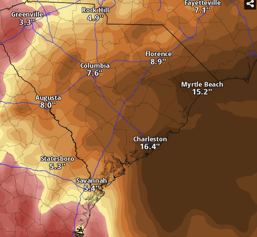
00z Euro stalls 94L and floods the lowcountry up to Wilmington. Widespread total qpf 15-20"
This post was edited on 9/26/25 at 11:04 am
Posted on 9/26/25 at 12:45 pm to Mr Roboto
That would not be ideal.
Posted on 9/26/25 at 12:55 pm to PsychTiger
Posted on 9/26/25 at 4:00 pm to CarolinaGamecock99

Posted on 9/26/25 at 4:02 pm to Mr Roboto
Jim Cantore gooning like a mofo right now.
Posted on 9/26/25 at 4:10 pm to OysterPoBoy
It looks like a stall right before the coast is a real possibility. My question is if it stalls off the coast for a day or two, is it possible for it to get pulled out to sea and not make landfall?

Posted on 9/26/25 at 4:10 pm to CarolinaGamecock99
I dont have any contacts in South or North Carolina. We have enlarged the area where we will respond and I need to make some contacts there.
If anyone knows someone in those areas I could connect to please send an email to
info@heretoserveinc.org
Thanks, And if you dont know us we provide free meals to disaster victims, usually after hurricanes and tornados. We can provide 1000 lunches and dinners a day usually for a week or so after a storm.
We have responded to Louisiana, Mississippi, Alabama, Florida and Georgia.
Posted on 9/26/25 at 4:10 pm to OysterPoBoy
Loading Twitter/X Embed...
If tweet fails to load, click here. quote:
Put bluntly, there is a 50% chance someone in the Carolinas experiences a flood disaster next week.
I understand that's a frustrating forecast. How do you plan for a 50 percent chance of a high-impact event? Prepare as if it's going to happen. If it does, you'll be ready. If it doesn't, you'll be blessed.
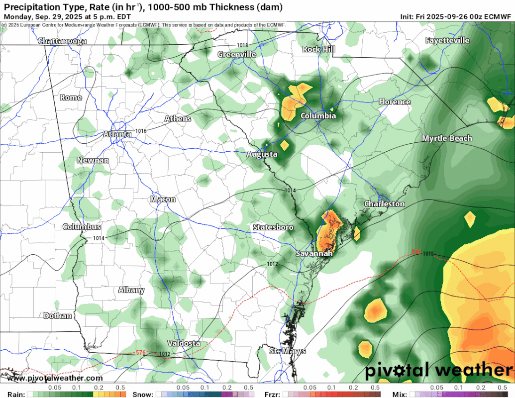
The European model simulates up to 2 feet (or more) of rain falling near the coastline between Sunday and Wednesday associated with what will become Tropical Storm or Hurricane Imelda. The American GFS model paints a swath of 10 to 14 inches.
The Canadian GEM model has a similar 18 inch jackpot, but keeps it just offshore. The German ICON model, which appears to have "initialized" with the incorrect starting point of our developing system, simulates Imelda heading out to sea.
We are VERY uncertain of what future Imelda will do. It will be involved in a game of atmospheric tug-of-war early next week; an upper-level low will want to pull it west, but Humberto, another hurricane, will try to tug it east. Which will win out? If it treks west, we get very heavy rainfall and flooding. If it slips east out to sea, we see minimal impacts. The former scenario is more likely.
What's even more concerning is the potential for a stall. With competing west and east pulls on the system, it's possible that future Imelda won't move much at all. If it stalls near the coast, somebody could get very heavy rain, but there's also a chance that heaviest band stays over the water.
We know you want answers. We want to give you direct answers! But we won't know too many specifics until a cohesive center forms within the system, allowing for better modeling. Check back for updates but please – take this seriously!
Posted on 9/26/25 at 4:18 pm to boxcarbarney
Posted on 9/26/25 at 5:32 pm to CobraCommander83
quote:
It looks like a stall right before the coast is a real possibility. My question is if it stalls off the coast for a day or two, is it possible for it to get pulled out to sea and not make landfall?
18z GFS shows a stall and then takes it out east. The slower development and movement appear to favor that solution. Quicker development and movement could have allowed flow around the upper low to move the system onshore, like some previous GFS runs.
Posted on 9/26/25 at 6:13 pm to rds dc
Thanks 

 Page 2 of 6

Popular
Back to top