- My Forums
- Tiger Rant
- LSU Recruiting
- SEC Rant
- Saints Talk
- Pelicans Talk
- More Sports Board
- Fantasy Sports
- Golf Board
- Soccer Board
- O-T Lounge
- Tech Board
- Home/Garden Board
- Outdoor Board
- Health/Fitness Board
- Movie/TV Board
- Book Board
- Music Board
- Political Talk
- Money Talk
- Fark Board
- Gaming Board
- Travel Board
- Food/Drink Board
- Ticket Exchange
- TD Help Board
Customize My Forums- View All Forums
- Show Left Links
- Topic Sort Options
- Trending Topics
- Recent Topics
- Active Topics
Started By
Message
re: Hurricane Iota - No Más! No Más! - Gulf Finally Closed?
Posted on 10/31/20 at 3:40 pm to BamaCoaster
Posted on 10/31/20 at 3:40 pm to BamaCoaster
 1
1


Posted on 10/31/20 at 3:53 pm to cgrand
quote:
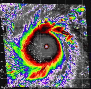
pressures in the 880’s.
quote:this has to be approaching a record for landfall for both right?
Estimated winds on approach to landfall are ~195mph.
Posted on 10/31/20 at 4:16 pm to WestCoastAg
quote:
this has to be approaching a record for landfall for both right?
Haiyan currently holds the record. This one is going to challenge it.
Posted on 10/31/20 at 4:23 pm to LegendInMyMind
quote:
Haiyan currently holds the record. This one is going to challenge it.
I don't know why... but the opening sentence on the Wiki for Haiyan made me lol
quote:
Typhoon Haiyan, known in the Philippines as Super Typhoon Yolanda

Posted on 10/31/20 at 4:34 pm to rt3
quote:
Super Typhoon Yolanda

Posted on 10/31/20 at 4:36 pm to Duke
quote:
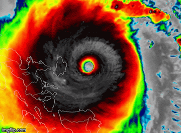
Holy frick! O_O
Thats the most impressive microwave imagery I can ever remember seeing.
Yeah. It has to be one if the most "perfect" storms to ever form.

Posted on 10/31/20 at 4:37 pm to Duke
Duke is this an annular hurricane?
Posted on 10/31/20 at 4:39 pm to Cosmo
quote:
Duke is this an annular hurricane?

That's going to be a no there. Back for he suffering of watching LSU football.

Posted on 10/31/20 at 4:50 pm to Duke

Posted on 10/31/20 at 4:59 pm to rds dc
Poop
Posted on 10/31/20 at 5:05 pm to Bobby OG Johnson
Good Lord, I can't imagine that.
Posted on 10/31/20 at 5:07 pm to LegendInMyMind
Some video here:
quote:
San Carlos Tabaco City, today (0550H). Strong winds and rain since 0200H. Stay safe to us! #rollyph @ABSCBNNews @ANCALERTS @gmanews @PhilstarNews @inquirerdotnet LINK
Posted on 10/31/20 at 5:10 pm to LegendInMyMind
quote:
Infrared imagery shows the immediate weakening of Super Typhoon #Goni (#RollyPH) as a result of land interaction with Catanduanes Island. Notice the immediate filling of the eye with warmer cloud tops. @iCyclone @pppapin LINK

Posted on 10/31/20 at 5:11 pm to LegendInMyMind
quote:
Notice the immediate filling of the eye with warmer cloud tops
Such a nothing burger
Posted on 10/31/20 at 7:03 pm to fightin tigers
Posted on 10/31/20 at 10:21 pm to LegendInMyMind
Hello Eta... 2005 tied
quote:
Tropical Storm Eta
...TROPICAL DEPRESSION BECOMES TROPICAL STORM ETA... ...HURRICANE WATCH ISSUED FOR PORTIONS OF THE NORTHEASTERN COASTS OF NICARAGUA AND HONDURAS...
11:00 PM EDT Sat Oct 31
Location: 15.0°N 74.2°W
Moving: W at 15 mph
Min pressure: 1005 mb
Max sustained: 40 mph
Posted on 10/31/20 at 10:25 pm to LegendInMyMind
quote:
The video in this Tweet seems to be from inside a shopping mall of some sort when Goni was making landfall.
Keep em coming. I hunted for live streams and videos earlier with no luck. Morbid curiosity with seeing how this thing looked from the ground when it hit.
Posted on 10/31/20 at 10:39 pm to AmosMosesAndTwins
Another one. That wind is hellish!
quote:
Tifon Goni de categoría 5, golpea con vientos fuertes a #Filipinas. Los vientos máximos son 290-300 km/h. ??
#Huracan #tifon #Goni #Filipinas #ULTIMAHORA #internacional LINK
Posted on 10/31/20 at 10:41 pm to LegendInMyMind
More wind:
quote:
#RollyPH bringing maximum sustained winds of 225 km/h near the center and gustiness of up to 310 km/h.
Super #Typhoon #Goni made 2 landfalls Sunday in the #Philippines Catanduanes and Albay. Over 300,000 have fled their homes. LINK

 Page 9 of 40

Popular
Back to top