- My Forums
- Tiger Rant
- LSU Recruiting
- SEC Rant
- Saints Talk
- Pelicans Talk
- More Sports Board
- Fantasy Sports
- Golf Board
- Soccer Board
- O-T Lounge
- Tech Board
- Home/Garden Board
- Outdoor Board
- Health/Fitness Board
- Movie/TV Board
- Book Board
- Music Board
- Political Talk
- Money Talk
- Fark Board
- Gaming Board
- Travel Board
- Food/Drink Board
- Ticket Exchange
- TD Help Board
Customize My Forums- View All Forums
- Show Left Links
- Topic Sort Options
- Trending Topics
- Recent Topics
- Active Topics
Started By
Message
re: Hurricane Season - 95L NHC 60% - Intertropical Convergence Zone Spin
Posted on 7/21/23 at 9:40 am to OysterPoBoy
Posted on 7/21/23 at 9:40 am to OysterPoBoy
quote:
Surprise, surprise. Right at New Orleans. They don’t even try to hide it anymore. For those scoring at home make sure to draw that cone in pencil because she will be moving a lot.
When I was a kid Bob Breck was famous for this. I think it was Hurricane Georges that was literally hours from landfall in Florida and he’s on the news saying “we’re not out of the woods yet.”
 0
0


Posted on 7/21/23 at 10:21 am to rmnldr
quote:
Check out the GFS, guys!
well you can just go right on and frick yourself silly
This post was edited on 7/21/23 at 10:21 am

Posted on 7/21/23 at 10:47 am to udtiger
Tiny storm. I'd reckon it intensifies quickly into a TS
Posted on 7/21/23 at 11:00 am to rmnldr
quote:
Tiny storm. I'd reckon it intensifies quickly into a TS
Got to pad the stats each Hurricane season.
Next thing you know when two clouds touch in the Atlantic it will be calling it the next superstorm.
This post was edited on 7/21/23 at 11:00 am
Posted on 7/21/23 at 11:01 am to Tarps99
Seriously, its like the models have a SE Louisiana target they need to hit. Thing is on rails straight into NOLA.

Posted on 7/21/23 at 11:21 am to rmnldr
quote:


Posted on 7/21/23 at 11:28 am to tunechi
Cat 1 at landfall at best. Good soaking, rain maker for Central LA and MS.

Posted on 7/21/23 at 11:34 am to Clyde Tipton
The accuracy of this is usually not great…
I’d imagine tomorrow’s run will be nowhere near Louisiana
I’d imagine tomorrow’s run will be nowhere near Louisiana
Posted on 7/21/23 at 11:40 am to longhorn22
quote:
The accuracy of this is usually not great…
I’d imagine tomorrow’s run will be nowhere near Louisiana
Tomorrow's run? The 06z GFS killed it completely. The 12z developed it briefly south of Puerto Rico before killing it.

Posted on 7/21/23 at 11:41 am to rds dc
These folks want some new artwork in their corporate office.


Posted on 7/21/23 at 12:02 pm to LegendInMyMind
Andddddd its gone
Posted on 7/21/23 at 12:10 pm to rds dc

Posted on 7/21/23 at 12:14 pm to rds dc
Oh boy…..

Posted on 7/21/23 at 12:21 pm to dukke v
Hurricane possibly forming and the Biden Administration wants to ban gas powered generators.
Are these people insane?
https://thefederalistpapers.org/us/proposed-new-biden-rule-essentially-bans-portable-gas-powered-generators-currently-market
Are these people insane?
https://thefederalistpapers.org/us/proposed-new-biden-rule-essentially-bans-portable-gas-powered-generators-currently-market
Posted on 7/21/23 at 12:42 pm to rds dc
Tropical Weather Outlook
NWS National Hurricane Center Miami FL
200 PM EDT Fri Jul 21 2023
For the North Atlantic...Caribbean Sea and the Gulf of Mexico:
Active Systems:
The National Hurricane Center is issuing advisories on Tropical
Storm Don, located over the central Atlantic.
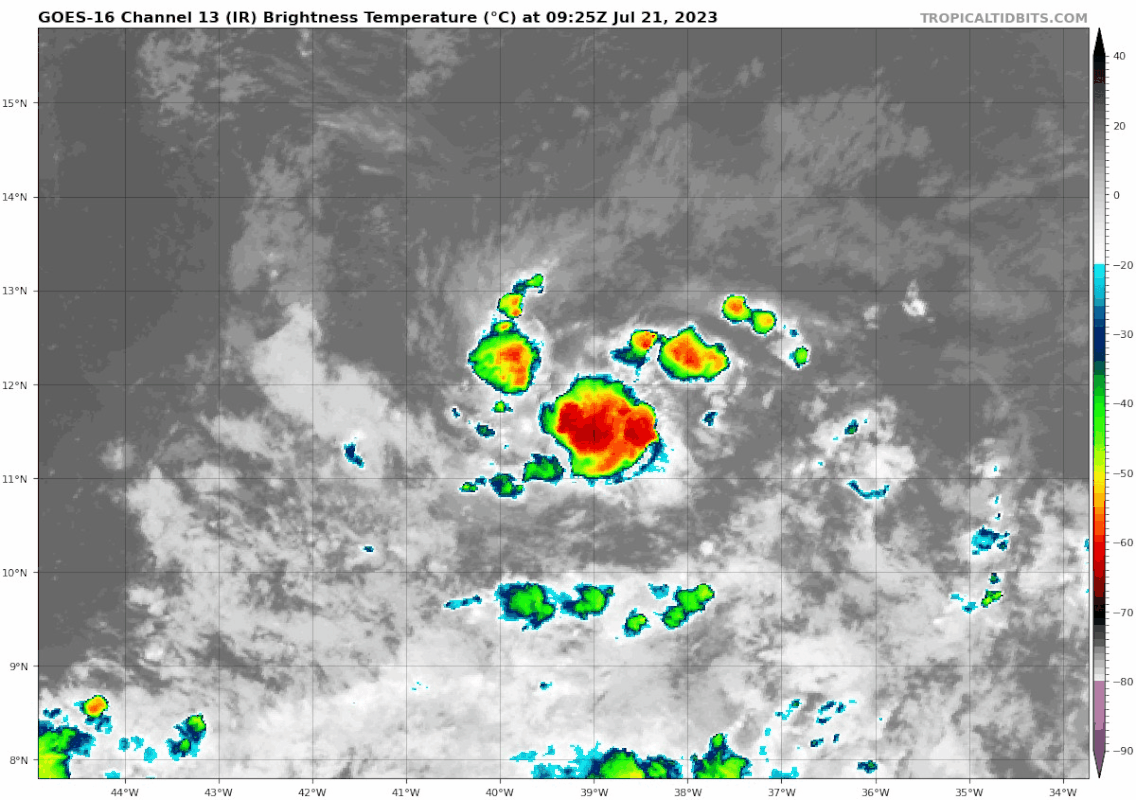
1. Central Tropical Atlantic (AL95):
A small area of low pressure, located several hundred miles
west-southwest of the Cabo Verde Islands, is producing an area of
disorganized showers and thunderstorms over the central tropical
Atlantic. Although there is dry air located to the north of
the system, favorable upper-level winds are expected to allow for
gradual development during the next several days. This system
could become a tropical depression early next week, as it moves
westward across the tropical Atlantic.
* Formation chance through 48 hours...medium...40 percent.
* Formation chance through 7 days...medium...60 percent.
Forecaster Kelly/Brown
NWS National Hurricane Center Miami FL
200 PM EDT Fri Jul 21 2023
For the North Atlantic...Caribbean Sea and the Gulf of Mexico:
Active Systems:
The National Hurricane Center is issuing advisories on Tropical
Storm Don, located over the central Atlantic.
1. Central Tropical Atlantic (AL95):
A small area of low pressure, located several hundred miles
west-southwest of the Cabo Verde Islands, is producing an area of
disorganized showers and thunderstorms over the central tropical
Atlantic. Although there is dry air located to the north of
the system, favorable upper-level winds are expected to allow for
gradual development during the next several days. This system
could become a tropical depression early next week, as it moves
westward across the tropical Atlantic.
* Formation chance through 48 hours...medium...40 percent.
* Formation chance through 7 days...medium...60 percent.
Forecaster Kelly/Brown
Posted on 7/21/23 at 12:43 pm to rds dc
Dude really
Posted on 7/21/23 at 12:45 pm to Tarps99
quote:
Got to pad the stats each Hurricane season

Posted on 7/21/23 at 12:45 pm to rds dc
spoke too soon
Posted on 7/21/23 at 12:49 pm to notiger1997
How many millions of dollars of improvement will a cat 1/2 due to New Orleans.
If it hits BSL again they need to hire a NA to ward off the curse. Of course, when you build on a super ancient Indian burial ground the local tribes in the 1700s avoided like the plaque and called it “Devils Bayou” or something like that etc you are kinda asking for it.
If it hits BSL again they need to hire a NA to ward off the curse. Of course, when you build on a super ancient Indian burial ground the local tribes in the 1700s avoided like the plaque and called it “Devils Bayou” or something like that etc you are kinda asking for it.
Posted on 7/21/23 at 12:55 pm to TutHillTiger
quote:
How many millions of dollars of improvement will a cat 1/2 due to New Orleans.
How about you frick off? How about that?
And it’s sad that this has to be said, and the usuals know this on the OT, but it’s waaaaay to soon to even think about where this system may go.

 Page 4 of 6

Popular
Back to top