- My Forums
- Tiger Rant
- LSU Recruiting
- SEC Rant
- Saints Talk
- Pelicans Talk
- More Sports Board
- Fantasy Sports
- Golf Board
- Soccer Board
- O-T Lounge
- Tech Board
- Home/Garden Board
- Outdoor Board
- Health/Fitness Board
- Movie/TV Board
- Book Board
- Music Board
- Political Talk
- Money Talk
- Fark Board
- Gaming Board
- Travel Board
- Food/Drink Board
- Ticket Exchange
- TD Help Board
Customize My Forums- View All Forums
- Show Left Links
- Topic Sort Options
- Trending Topics
- Recent Topics
- Active Topics
Started By
Message

 1
1

Posted on 10/6/17 at 10:54 pm to shawnlsu
Correct, rapid intensification.
Posted on 10/6/17 at 10:54 pm to 50_Tiger
SLack are yall staying up tonight? I might just get a pot of coffee going and watch this come in.
Posted on 10/6/17 at 10:54 pm to Duke
quote:
Dont understand why the cone is so narrow on this one
Cone is historical error out to 1 standard deviation. So 66% of the time the path is within the cone at a given time out, and 34% it is outside of it. The cone is not necessarily forecast uncertainty.
And to add to that, it's based on the error at a given time frame. 12 hours, 24 hrs, 36, 48, 72, etc. Nate is moving at 22 MPH, so it covers a shite ton of ground in 12 hours. That's why the cone seems so narrow given how far Nate still has to travel.
That being said, there's still quite a bit of certainty in the track of Nate, it's the intensity that's going to be difficult to pin down.
Posted on 10/6/17 at 10:54 pm to purplepylon
quote:
I don't understand why they took a majority of Louisiana out of the cone
I don't know what percentage chance there is, if any, that this thing ends up more west but with all of La out of the cone, and this thing moving as fast as it is, that could cause some people to get caught off guard.
I could understand a cone like that if it was gonna take 3 days for it to get here but with 24 hours or so and relying so much on that hard northeast turn people in S La could get caught with their pants down
Posted on 10/6/17 at 10:55 pm to shawnlsu
Yes. Definitely been a trend this hurricane season too which is the unfortunate thing. We're in October and the GOM can still support a major hurricane.
Posted on 10/6/17 at 10:56 pm to East Coast Band
quote:
OK, we are at page 117. I'm hoping by daybreak tomorrow we are no more than about page 120. If we are up to page 150 or so, the entire Gulf coast is f*cked.
Probably as good a barometer as any.
Posted on 10/6/17 at 10:56 pm to 50_Tiger
They predicted 40+ inches of rain for Harvey' wtf is happening
Posted on 10/6/17 at 10:58 pm to slackster
It's funny he said that because usually the first thing I do when I wake up in the morning is open this thread on my phone and look at the page count. If I see it blew up before I went to bed I know someone has their arse puckered.
Posted on 10/6/17 at 10:58 pm to deuce985
quote:
The forecasts warned it every time with a pretty high probability.
Yes, NHC has done a great job with this system. They have hammered the potential for RI in the discussions and have constantly been higher than the models for intensification.
Posted on 10/6/17 at 10:58 pm to rocket31
We're talking about the rapid intensification of the storm man. Why is that so hard for you to understand?
Posted on 10/6/17 at 11:00 pm to rocket31
Harvey was initially a wave in the S Gulf that no one batted an eye at. 1 Day later you have damn near what you are seeing now with Nate. Difference is Nate is moving WAYYY faster.
It won't be a Harvey, but it won't be something you are just going meh about.
It won't be a Harvey, but it won't be something you are just going meh about.

Posted on 10/6/17 at 11:00 pm to MrSmith

Posted on 10/6/17 at 11:00 pm to FelicianaTigerfan
Guess what I'm saying is, cone shouldn't narrow based on time, as much as it should on distance.
But I don't know shite about none of this so I'll be quiet and just read along with the class
But I don't know shite about none of this so I'll be quiet and just read along with the class
This post was edited on 10/6/17 at 11:03 pm

Posted on 10/6/17 at 11:00 pm to purplepylon

Posted on 10/6/17 at 11:00 pm to slackster
Jeff P said it just made it to hurricane level. He's projecting a strong Cat 2 according to models. Says the storm is venting and expanding out.
Posted on 10/6/17 at 11:01 pm to rocket31
quote:
hey predicted 40+ inches of rain for Harvey' wtf is happening
He's mentioning Harvey and the other storms because they all went through a rapid intensification process. Some were predicted better than others, but it happened with all of them.
It may be occurring with Nate too.
The rest of the storm dynamics are completely different.
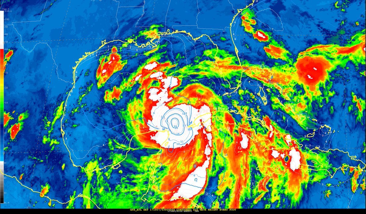
Posted on 10/6/17 at 11:01 pm to rds dc
NHC TAFB analysis showing 20+ ft waves
Posted on 10/6/17 at 11:02 pm to FelicianaTigerfan
quote:
Guess what I'm saying is, cone shouldn't narrow based on time, as much as it should on distance.
I'd imagine they've looked at it numerous ways, but it's a thought for sure.
Posted on 10/6/17 at 11:02 pm to deuce985
quote:
It's funny he said that because usually the first thing I do when I wake up in the morning is open this thread on my phone and look at the page count. If I see it blew up before I went to bed I know someone has their arse puckered
speaking of arse puckering...
the Mercedes-Benz Stadium Roof Sphincter Pucker Scale sponsored by Chick-fi-A (we're closed on your game days)
Morgan City,LA to AL/FL border = 5/10
This post was edited on 10/6/17 at 11:02 pm

 Page 118 of 193

Popular
Back to top