- My Forums
- Tiger Rant
- LSU Recruiting
- SEC Rant
- Saints Talk
- Pelicans Talk
- More Sports Board
- Fantasy Sports
- Golf Board
- Soccer Board
- O-T Lounge
- Tech Board
- Home/Garden Board
- Outdoor Board
- Health/Fitness Board
- Movie/TV Board
- Book Board
- Music Board
- Political Talk
- Money Talk
- Fark Board
- Gaming Board
- Travel Board
- Food/Drink Board
- Ticket Exchange
- TD Help Board
Customize My Forums- View All Forums
- Show Left Links
- Topic Sort Options
- Trending Topics
- Recent Topics
- Active Topics
Started By
Message

 0
0


Posted on 9/11/18 at 12:02 pm to 50_Tiger
Posted on 9/11/18 at 12:03 pm to tokenBoiler
quote:
there has to be some seriously interesting math going on in an EWRC.
Without a doubt. Momentum conservation/fluids applications, thermodynamics, ect.
I'd think it's a move for increased stability to increase the potential heat flux. The center gets bigger when they do it, so it might lose a bit of wind spead, it spreads the max winds over a larger area and helps get that ocean spraying up mist to grab up more of that sweet latent heat. Additionally, the larger size probably allows a better means of distributing the energy it is picking up. Plus, a smaller circulation can be more intense but is typically pretty fragile to surrounding conditions.
Speculating of course, but it's for me a damn interesting part of these monster storms.
Posted on 9/11/18 at 12:04 pm to 50_Tiger
Posted on 9/11/18 at 12:05 pm to CidCock
quote:
Can someone explain the discrepancy between the NHC official forecast and the Euro model that our local weatherman keeps scaring everyone with?
Euro is one model that NHC uses, but not the full picture. Each of the models have little quirks with how they address features in the atmosphere, and the humans at the NHC try to put together the best solution from what they depict.
The main reason your local guy is pumping the Euro is pretty obvious though, it paints a worse picture for SC than the rest of them do.
Posted on 9/11/18 at 12:06 pm to MountainTiger
quote:
One of the true weather geeks here could probably give you a better answer but I think it has to do with the uncertainty of what the storm is going to do once it makes landfall. If it stalls, the rainfall amounts will go way up. But nobody's really sure what it's going to do.
Yeah, I certainly understand that. Just curious as to why the NHC predictions don't appear to be picking up the stall. I thought the NHC used a best fit model of the GFS and Euro.
I guess that's the question, where does NHC get their predictions?
Posted on 9/11/18 at 12:06 pm to Duke

This will turn some heads. GFS FV3 now bringing Flo back south to NC/SC line.

Posted on 9/11/18 at 12:06 pm to Duke
Generator acquired. Beer fridge and tv will have power. 

Posted on 9/11/18 at 12:07 pm to rds dc
I see that landfall has been pushed back to 8 am Friday morning as of now
Posted on 9/11/18 at 12:08 pm to NYNolaguy1
quote:
This will turn some heads. GFS FV3 now bringing Flo back south to NC/SC line.
So now GFS...and Euro solutions more towards SC/NC border? See where the next nhc track shifts
Posted on 9/11/18 at 12:09 pm to CidCock
quote:
where does NHC get their predictions?
They are basically the College Football Playoff committee, have the data..do their best to project from the data
This post was edited on 9/11/18 at 12:37 pm
Posted on 9/11/18 at 12:13 pm to CidCock
quote:
Can someone explain the discrepancy between the NHC official forecast and the Euro model that our local weatherman keeps scaring everyone with?
In the Columbia area, NHC is showing 2" of rain vs the 10"+ in the Euro.
The NHC takes into account more than just the Euro, for starters. Also, prior to the most recent GFS, there was quite a bit of discrepancy between the Euro and GFS on how Florence would react inland. The 12z GFS is much similar to the Euro now, so I'd imagine the Columbia forecast totals might come up a bit, but not a ton quite yet.
As for the 12z GFS totals, this is the 48 hours ending Saturday afternoon:

Wilmington is going to catch it coming and going.
Posted on 9/11/18 at 12:14 pm to LaBR4
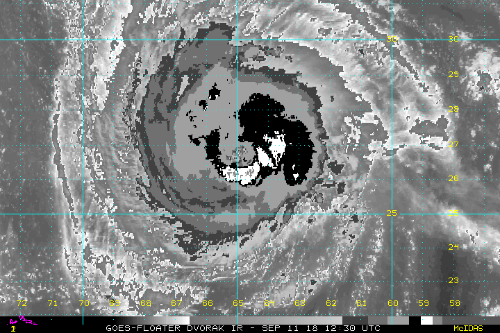
Dvorak improving too.
Posted on 9/11/18 at 12:18 pm to NYNolaguy1
quote:
then essentially 24 hours of hurricane conditions, with winds between 100-115 mph.
Damn. I really hope that doesn't happen to them. I've got to believe that would cause a lot of damage even to the things that were predicted and tested and built to standards to not get damaged.
Posted on 9/11/18 at 12:20 pm to NYNolaguy1
quote:
Dvorak improving too.
This is why im extremely curious why no HH right now.
I bet that storm is back up to 140+
Posted on 9/11/18 at 12:24 pm to NYNolaguy1
Got a black ring wrapped around, firing whites and a little of those warmer grays. Definitely stronger than this morning.

Posted on 9/11/18 at 12:25 pm to 50_Tiger
Passed about 50 bucket trucks headed east on I-10 a while ago, probably coming through Houston about now. Prayers up to everyone affected, wouldn't wish that kind of destruction on anyone after living through Harvey.
Posted on 9/11/18 at 12:26 pm to PsychTiger
quote:
Generator acquired. Beer fridge and tv will have power.
only the essentials
Posted on 9/11/18 at 12:26 pm to 50_Tiger
I've got family in Roanoke, VA. We haven't spoken to them about any of this. I'm just wondering how that part of the state will play out.
Posted on 9/11/18 at 12:26 pm to Golfer
quote:
No one wants to be Blanco or Nagin again.
That level of incompetency is hard to attain

 Page 196 of 400

Popular
Back to top