- My Forums
- Tiger Rant
- LSU Recruiting
- SEC Rant
- Saints Talk
- Pelicans Talk
- More Sports Board
- Fantasy Sports
- Golf Board
- Soccer Board
- O-T Lounge
- Tech Board
- Home/Garden Board
- Outdoor Board
- Health/Fitness Board
- Movie/TV Board
- Book Board
- Music Board
- Political Talk
- Money Talk
- Fark Board
- Gaming Board
- Travel Board
- Food/Drink Board
- Ticket Exchange
- TD Help Board
Customize My Forums- View All Forums
- Show Left Links
- Topic Sort Options
- Trending Topics
- Recent Topics
- Active Topics
Started By
Message

 0
0

Posted on 9/8/18 at 10:02 am to rds dc
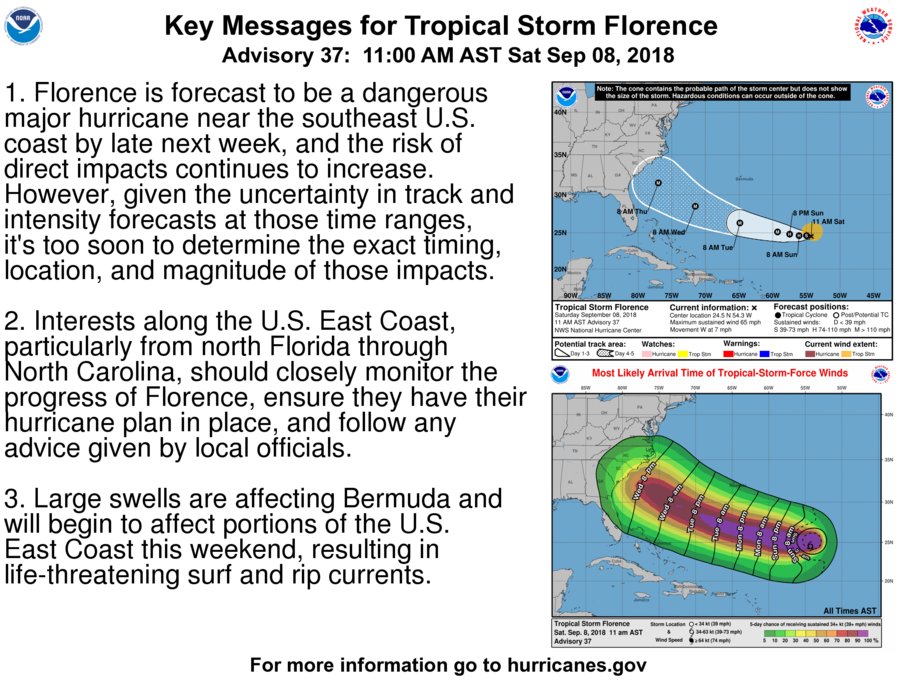
Tropical Storm Florence Discussion Number 37
NWS National Hurricane Center Miami FL AL062018
1100 AM AST Sat Sep 08 2018
Florence has undergone a dramatic structural evolution just within
the past 6 hours or so. Vertical shear has decreased just enough
for the storm to take on a more symmetric shape, with convection
developing in a ring around the low-level center, and an elongated
band wrapping around to the northeastern part of the circulation.
The convection has waned a little bit in intensity, however, due to
the presence of dry air, and Dvorak estimates support maintaining
an initial intensity of 55 kt for now. A NOAA P-3 aircraft is
approaching Florence now on a research mission and should provide
some useful data to better assess the storm's intensity.
Recent WindSat microwave data revealed that Florence has a
well-defined low-level ring in the 37-GHz channel, which tends to
be a harbinger of strengthening when environmental conditions are
favorable. Since vertical shear is decreasing and should be 10 kt
or less by later today, and Florence is heading toward a deeper
pool of warm water over the southwestern Atlantic, a significant
phase of intensification is likely to begin by tonight, continuing
through Tuesday or Wednesday. In fact, the official intensity
forecast explicitly shows rapid intensification occurring between
24 and 48 hours from now, and Florence is expected to become a
major hurricane by Monday. The HFIP Corrected Consensus (HCCA) and
the Florida State Superensemble (FSSE), both of which tend to do
well in these scenarios, are both near the upper end of the guidance
suite, especially through day 3. Even by days 4 and 5, the HWRF,
HMON, and ICON intensity consensus are near the top end of the
guidance, close to HCCA and FSSE. Given the signals in the
environment, and the solutions provided by these models, the NHC
intensity forecast shows Florence reaching category 4 intensity by
day 3 and maintains that through the end of the forecast period.
Florence's longer-term motion is 265/6 kt. The cyclone appears to
be slowing down as was expected, and this type of motion is likely
to continue for the next 24-36 hours. In fact, the track guidance
has slowed down during this period, and the updated NHC track
forecast is a little slower than the previous one. After 36 hours,
the most notable change in the models was a northeastward shift in
the 06Z GFS. However, that run appears to be an outlier from the
rest of the dynamical models, and its trend opposes the slight
westward shift noted in the HCCA and FSSE aids. The updated NHC
track forecast is therefore very close to or slightly west of the
previous forecast on days 4 and 5. The exact path of Florence as it
approaches the southeastern U.S. coastline will depend heavily on
the position and strength of the blocking high pressure that is
expected to develop north of Bermuda and extend westward over the
eastern U.S., and so far there has not been much more clarity on
those important details.
Key Messages:
1. Florence is forecast to be a dangerous major hurricane near the
southeast U.S. coast by late next week, and the risk of direct
impacts continues to increase. However, given the uncertainty in
track and intensity forecasts at those time ranges, it's too soon to
determine the exact timing, location, and magnitude of those
impacts.
2. Interests along the U.S. East Coast, particularly from north
Florida through North Carolina, should closely monitor the progress
of Florence, ensure they have their hurricane plan in place, and
follow any advice given by local officials.
3. Large swells are affecting Bermuda and will begin to affect
portions of the U.S. East Coast this weekend, resulting in
life-threatening surf and rip currents.
FORECAST POSITIONS AND MAX WINDS
INIT 08/1500Z 24.5N 54.3W 55 KT 65 MPH
12H 09/0000Z 24.6N 55.0W 60 KT 70 MPH
24H 09/1200Z 24.6N 56.1W 70 KT 80 MPH
36H 10/0000Z 24.8N 57.5W 85 KT 100 MPH
48H 10/1200Z 25.1N 59.3W 100 KT 115 MPH
72H 11/1200Z 26.3N 64.9W 115 KT 130 MPH
96H 12/1200Z 28.5N 71.5W 125 KT 145 MPH
120H 13/1200Z 31.5N 77.0W 120 KT 140 MPH
$$
Forecaster Berg
Posted on 9/8/18 at 10:05 am to rds dc
What’s the pressure on that?
Posted on 9/8/18 at 10:08 am to rds dc
06z HMON (this season it is coupled to the ocean via HYCOM - in simplest terms, this means that the model is influenced by ocean surface temps. It wasn't coupled in the Atlantic last season and that resulted in a bunch of crazy bombs.)

Posted on 9/8/18 at 10:09 am to bubbz
quote:
What’s the pressure on that?
That HWRF run was 937mb

Posted on 9/8/18 at 10:27 am to rds dc
quote:
1st Florence Recon
the ladies on Weekend Recharge (TWC) thought the plane was going to sample the atmosphere around the storm
but I went to Topical Tidbits and it looks like the plane's in the storm and not doing an atmosphere sample around it
Posted on 9/8/18 at 10:29 am to rt3
Florence gonna pull Invest 94L into it?
Posted on 9/8/18 at 10:42 am to rds dc
already a 4mb drop in pressure from the 10 am advisory.
Posted on 9/8/18 at 10:57 am to lsuman25
I'm not able to see the dropsonde data 
Posted on 9/8/18 at 11:07 am to lsuman25
0z Euro wind gusts
7PM Thursday

6z GFS wind gusts
4 AM Friday

7PM Thursday
6z GFS wind gusts
4 AM Friday
This post was edited on 9/8/18 at 11:13 am
Posted on 9/8/18 at 11:12 am to rt3
so... if I'm reading this right... no sheer (at least in the NE quadrant)

Posted on 9/8/18 at 11:26 am to rt3
991 mb at the surface in the eye
Posted on 9/8/18 at 12:06 pm to rt3
quote:
(TWC) thought the plane was going to sample the atmosphere around the storm
but I went to Topical Tidbits and it looks like the plane's in the storm and not doing an atmosphere sample around it
It is but this isn't an upper air mission, that will fly later and sample a much larger region of the Atlantic.
This current mission:

Posted on 9/8/18 at 12:10 pm to rds dc
yes... the radiation hazard symbol pattern
Posted on 9/8/18 at 12:33 pm to rds dc

GFS parks it at katrina strength off the coast then pulls it away into the atlantic

Posted on 9/8/18 at 12:35 pm to DVinBR
I do not remember A time when the tropics have been this active at one time,,,,,,

Posted on 9/8/18 at 12:36 pm to DVinBR
Governor of South Carolina has already declared a State of Emergency for SC over Florence.
They’re showing his press conference instead of the USF-Ga Tech game.
They’re showing his press conference instead of the USF-Ga Tech game.
Posted on 9/8/18 at 12:40 pm to dukke v
quote:
I do not remember A time when the tropics have been this active at one time,,,,,,
Umm, last year?
Posted on 9/8/18 at 12:42 pm to slackster
Smart arse
Lol
Lol

 Page 110 of 400

Popular
Back to top