- My Forums
- Tiger Rant
- LSU Recruiting
- SEC Rant
- Saints Talk
- Pelicans Talk
- More Sports Board
- Coaching Changes
- Fantasy Sports
- Golf Board
- Soccer Board
- O-T Lounge
- Tech Board
- Home/Garden Board
- Outdoor Board
- Health/Fitness Board
- Movie/TV Board
- Book Board
- Music Board
- Political Talk
- Money Talk
- Fark Board
- Gaming Board
- Travel Board
- Food/Drink Board
- Ticket Exchange
- TD Help Board
Customize My Forums- View All Forums
- Show Left Links
- Topic Sort Options
- Trending Topics
- Recent Topics
- Active Topics
Started By
Message

 1
1


Posted on 8/28/19 at 10:59 am to Fun Bunch
NHC obviously isnt buying the old icon
Posted on 8/28/19 at 10:59 am to lsugolfredman
quote:
Last frame for 12Z Icon
Looking at the 500 heights and I think that would turn north toward Mobile if it kept running out.
Posted on 8/28/19 at 11:00 am to Motorboat
quote:
frick that. I'm going to Pensacola no matter.
Well I'm going out of the country on a plane. I don't want to be stuck in another country and not able to fly back.
No, I'm not downplaying the massive destruction this storm may do so don't downvote away.
I'm very concerned about that. I can't deal with another damn Katrina.
This post was edited on 8/28/19 at 11:02 am
Posted on 8/28/19 at 11:04 am to Duke
12z GFS coming more in line with Euro so far.
Posted on 8/28/19 at 11:04 am to Fun Bunch
Looks like my trip to Destin next week may be shot. 
Posted on 8/28/19 at 11:05 am to Fun Bunch
quote:
Well I'm going out of the country on a plane. I don't want to be stuck in another country and not able to fly back.
Go man. you can always fly back into another airport. I thought you were the poster going to OB.
Posted on 8/28/19 at 11:06 am to Duke
quote:
12z GFS coming more in line with Euro so far.
Meaning...what?
Posted on 8/28/19 at 11:06 am to Tchefuncte Tiger
quote:
Looks like my trip to Destin next week may be shot.
I wouldn't change plans because of one model run.

Posted on 8/28/19 at 11:07 am to Fun Bunch
quote:
Meaning...what?
You guys are fine. The east coast needs to start worrying.
Posted on 8/28/19 at 11:08 am to Fun Bunch
quote:
Meaning...what?
It has been wanting it to get north toward the Carolinas. It's now following a path more like the NHC path and pushing to have it go in by the Space Coast.

Posted on 8/28/19 at 11:09 am to udtiger
quote:I just see titties
what the fresh hell is this shite?

Posted on 8/28/19 at 11:10 am to Duke
Tropical Tidbits going slow for anyone else? Looks like they have a lot of traffic on the site.
Posted on 8/28/19 at 11:10 am to Duke
quote:
I wouldn't change plans because of one model run.
I'm not, but the earlier NHC diagram had the storm going more towards Jacksonville/South Georgia and away from the GoM. Now it looks like it may make it in to the Gulf, but this will change 50 times in the next 24 hours. Who knows?
Posted on 8/28/19 at 11:11 am to BallsEleven
quote:
Tropical Tidbits going slow for anyone else? Looks like they have a lot of traffic on the site.
Yup. It's because the 12Z GFS is running right now.

Posted on 8/28/19 at 11:15 am to Centinel
Question for the storm gurus:
Could the low pressure system in the Atlantic (CLP5) push Dorian further South on the approach to Fl?
Could the low pressure system in the Atlantic (CLP5) push Dorian further South on the approach to Fl?
Posted on 8/28/19 at 11:15 am to BallsEleven
quote:
Tropical Tidbits going slow for anyone else? Looks like they have a lot of traffic on the site.
Probably some type of tropical activity.
Posted on 8/28/19 at 11:17 am to Tchefuncte Tiger
quote:
but the earlier NHC diagram had the storm going more towards Jacksonville/South Georgia and away from the GoM. Now it looks like it may make it in to the Gulf, but this will change 50 times in the next 24 hours. Who knows?
Ignore the center line or trends in the cone for now. The window is basically between the OBX and the mouth of the Mississippi with the most likely seeming Space Coast, enters gulf near Tampa and turns into the Panhandle somewhere.
Posted on 8/28/19 at 11:20 am to bamarep
quote:
Could the low pressure system in the Atlantic (CLP5) push Dorian further South on the approach to Fl?
Flow around it being counter clockwise would have it rotate N and then W around it, aligning it with the west push from the building high to it's north.
Posted on 8/28/19 at 11:22 am to CBarkleytruth
quote:
Starting to resemble Katrina’s path
Idiot

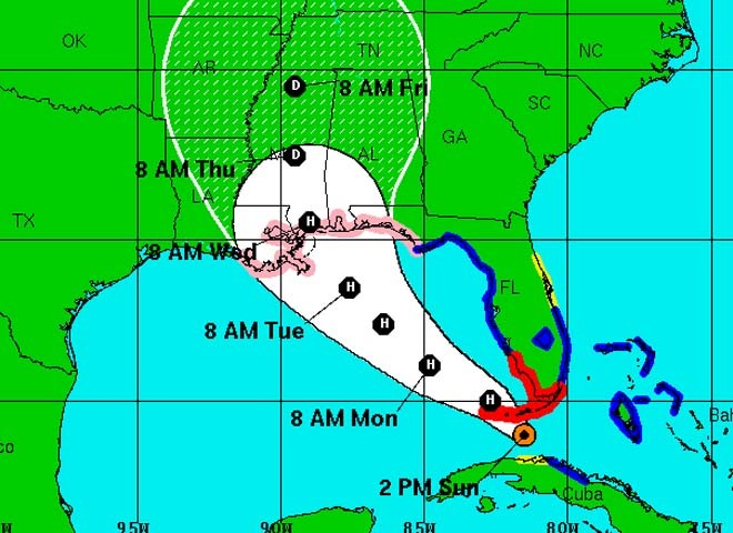
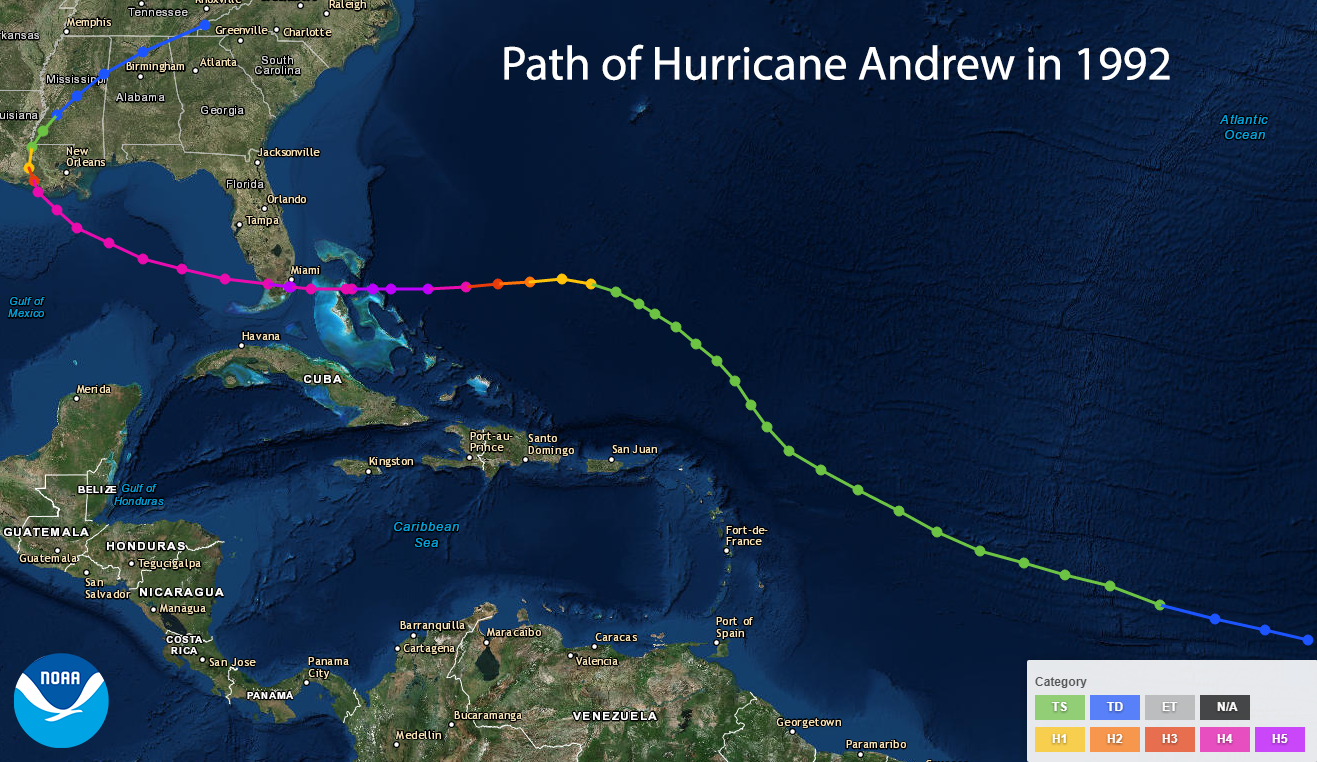
More of an Andrew track

 Page 25 of 263

Popular
Back to top