- My Forums
- Tiger Rant
- LSU Recruiting
- SEC Rant
- Saints Talk
- Pelicans Talk
- More Sports Board
- Fantasy Sports
- Golf Board
- Soccer Board
- O-T Lounge
- Tech Board
- Home/Garden Board
- Outdoor Board
- Health/Fitness Board
- Movie/TV Board
- Book Board
- Music Board
- Political Talk
- Money Talk
- Fark Board
- Gaming Board
- Travel Board
- Food/Drink Board
- Ticket Exchange
- TD Help Board
Customize My Forums- View All Forums
- Show Left Links
- Topic Sort Options
- Trending Topics
- Recent Topics
- Active Topics
Started By
Message

 3
3

Posted on 8/24/17 at 12:17 pm to Duke
Thanks Duke. That.....explains it....somewhat. 

Posted on 8/24/17 at 12:19 pm to When in Rome
quote:
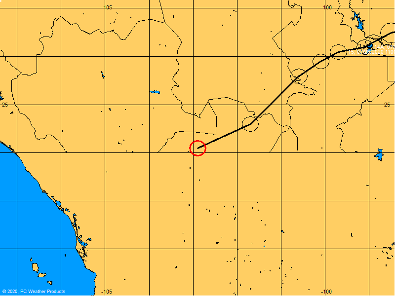
Anyone have any insight for Lafayette/BR/Covington/NOLA impact beyond it gon rain?
Is it def going to head east at this point?
Nothing in La. Main focus tbh would be the Houston metro area.
That's where all the money is.
As bad as that just sounded.
Posted on 8/24/17 at 12:20 pm to 50_Tiger

Posted on 8/24/17 at 12:20 pm to 50_Tiger
quote:
Nothing in La. Main focus tbh would be the Houston metro area.
That's where all the money is.
As bad as that just sounded.


Posted on 8/24/17 at 12:20 pm to When in Rome
its currently moving NNW....but a sunday/monday shift to the east is what most models are showing. obviously this thing will have lost a good bit of power by then. just have to watch if it pushes SSE back into the GOM to re-energize
Posted on 8/24/17 at 12:20 pm to GEAUXmedic
Posted on 8/24/17 at 12:21 pm to tigersbh
quote:
the Corpus area. The word from folks in the know on infrastructure is that this is going to be off the charts devastating
Yeah. Corpus Christi has not seen anything like this since 1970 (Celia). The population and infrastructure there has greatly increased over the past 47 years.
Posted on 8/24/17 at 12:22 pm to Ellis Dee
quote:
Pardon my ignorance, but what's the likelihood of it regaining strength when it "dips" back into the gulf after making landfall?
The weather guy on WAFB just said it could happen, and he didn't say it was highly unlikely.
Posted on 8/24/17 at 12:22 pm to tke857
quote:
but a sunday/monday shift to the east is what most models are showing. obviously this thing will have lost a good bit of power by then.

quote:
just have to watch if it pushes SSE back into the GOM to re-energize

This post was edited on 8/24/17 at 12:23 pm
Posted on 8/24/17 at 12:22 pm to GEAUXmedic
LOL!
You need wayyyyy more equipment to cover a what? 9 million population metro area, than lets say Houma, La.
You need wayyyyy more equipment to cover a what? 9 million population metro area, than lets say Houma, La.

Posted on 8/24/17 at 12:22 pm to When in Rome
quote:
Anyone have any insight for Lafayette/BR/Covington/NOLA impact beyond it gon rain?
Is it def going to head east at this point?


Posted on 8/24/17 at 12:23 pm to lsuhunt555
quote:
That image is what prompted me and my girlfriend to leave BR and head to North La.
We had left Chalmette on Saturday before the traffic got awful and were hanging out in Jackson, MS. I looked at my fiance (now my wife) and told her, the flood insurance is paid for, we have our most essential and unreplaceable possessions in the car, and I would not expect that we will be able to save much anything else. I just had a bad feeling.
Posted on 8/24/17 at 12:23 pm to rds dc
9
2
7?????????!!!!!
who was that poster that was still in CC?
MOFO LEAVE.
2
7?????????!!!!!
who was that poster that was still in CC?
MOFO LEAVE.

Posted on 8/24/17 at 12:23 pm to NorthEndZone
goes from forecast TS to Cat 3?
shite. Goes to show you power in gulf waters. And how we should always respect the potential intensities of these storms.
shite. Goes to show you power in gulf waters. And how we should always respect the potential intensities of these storms.
Posted on 8/24/17 at 12:23 pm to 50_Tiger


This post was edited on 8/24/17 at 12:24 pm
Posted on 8/24/17 at 12:25 pm to tke857
AndreaButera
MANDATORY evacuation issued for Port Aransas, TX in advance of #Harvey.
MANDATORY evacuation issued for Port Aransas, TX in advance of #Harvey.

Posted on 8/24/17 at 12:25 pm to rds dc
What is San Antonio going to get, especially early next week? Trying to decide if I need to pull the plug on an employee scheduled to get down there Monday.
Posted on 8/24/17 at 12:25 pm to GEAUXmedic
Alvin ISD close tomorrow.

 Page 86 of 618

Popular
Back to top