- My Forums
- Tiger Rant
- LSU Recruiting
- SEC Rant
- Saints Talk
- Pelicans Talk
- More Sports Board
- Fantasy Sports
- Golf Board
- Soccer Board
- O-T Lounge
- Tech Board
- Home/Garden Board
- Outdoor Board
- Health/Fitness Board
- Movie/TV Board
- Book Board
- Music Board
- Political Talk
- Money Talk
- Fark Board
- Gaming Board
- Travel Board
- Food/Drink Board
- Ticket Exchange
- TD Help Board
Customize My Forums- View All Forums
- Show Left Links
- Topic Sort Options
- Trending Topics
- Recent Topics
- Active Topics
Started By
Message
re: Harvey ***Catastrophic Flooding Event***
Posted on 8/29/17 at 4:20 pm to Uncle JackD

Posted on 8/29/17 at 4:20 pm to Uncle JackD
quote:
Bank repos it? What's the penalty for that besides wrecked credit? I've always wondered about this stuff
Probably walk away, declare bankruptcy, rent for several years while building up a big down payment on a new house in several years when out from under bankruptcy?
Do the people that have to walk away just take the credit hit or go the bankruptcy route?
 2
2


Posted on 8/29/17 at 4:20 pm to Duke

Posted on 8/29/17 at 4:21 pm to Scoop
Hope the word is out about the Chem plant in Crosby..
Posted on 8/29/17 at 4:21 pm to Jwho77
quote:
Video: freeway concrete barrier breaks away on Hwy 59 at San Jacinto Bridge.
Water is a powerful, unstoppable force
Posted on 8/29/17 at 4:21 pm to ihometiger
quote:
Crosby Chemical Plant is in process of evacuating due to potential for fire and/or explosion per KHOU. Didn't specify where the Crosby Chemical Plant is located though.
And now begins all the secondary disasters.
Christ, this must be what PTSD is like.

Posted on 8/29/17 at 4:22 pm to deltaland
quote:
Damn it's getting stronger. This fricker is almost as resilient as blue shed. But not quite
I thought you almost committed blasphemy, but I see you didn't.
Posted on 8/29/17 at 4:23 pm to deltaland
quote:
In rare situations like these I would have no problem with the government having some type of financial aid to help those without insurance
You will have FEMA aid and there will be some sort of Road Home type program.
Posted on 8/29/17 at 4:26 pm to Redbone
The thing to do in situations like this if you don't have flood insurance is get your valuables out as you're evacuating ahead of a certain flood and toss a match in it as you walk out
Posted on 8/29/17 at 4:29 pm to Uncle JackD
quote:That happened.
But then your upside down still owing the bank an assload I'd think. Unless the house is near paid off.
A guy in D.S. owed about $150k on his original loan. He had about $150k damages. I'm rounding off obviously. The loan company mandated he have flood insurance. FEMA told him he could not continue to get insurance if he didn't raise his house. It's a brick house. Some company wanted about $125k to raise the house. ....
He was interviewed on WBRZ and stated he didn't know what he was going to do. I never heard any more about it.
I would have walked away.
I would sell mine right now if it were not on 30 acres of inherited property.
We just rebuilt it in '07. Gustave nearly totaled it.
We are getting tired of this shite.
Posted on 8/29/17 at 4:30 pm to deltaland
The 50 inch barrier has been broken. Those crazy weather models weren't too crazy after all. 115-hour storm totals...
STORM SUMMARY NUMBER 15 FOR TROPICAL STORM HARVEY PRELIMINARY
RAINFALL TOTALS AND WIND REPORTS
NWS WEATHER PREDICTION CENTER COLLEGE PARK MD
400 PM CDT TUE AUG 29 2017
...TROPICAL STORM HARVEY PRELIMINARY OBSERVED RAIN TOTALS AND WIND
REPORTS...
FOR A DETAILED GRAPHICAL DEPICTION OF THE LATEST
WATCHES...WARNINGS AND ADVISORIES...PLEASE SEE WWW.WEATHER.GOV
AT 300 PM CDT...THESE ARE THE MOST RECENT PRELIMINARY RAINFALL AND
WIND REPORTS FROM TROPICAL STORM HARVEY. PLEASE REFER TO NHC FOR
THE LATEST PUBLIC ADVISORIES ON HARVEY.
...SELECTED PRELIMINARY STORM TOTAL RAINFALL IN INCHES FROM 800 PM
CDT THU AUG 24 THROUGH 300 PM CDT TUE AUG 29...
...LOUISIANA...
IOWA 0.9 ESE 14.88
LAKE CHARLES 11.5 SSW 13.25
INDIAN BAYOU AT COFFEY ROAD 12.80
LACASSINE BAYOU AT LORRAIN BRIDGE 12.68
HACKBERRY 5 SSE 12.33
RAGLEY 5.0 SE 12.06
W-14 AT JOE SPEARS RD 11.69
KENNER GULLY AT MARK LEBLEU 11.50
ZAVALLA 2 ESE 11.24
CHOUPIQUE BAYOU AT HWY 90 11.02
SULPHUR 2.2 E 11.00
GILLIS 4 WSW 10.94
CONTRABAND BAYOU AT 18TH STREET 10.78
LACASSINE NATIONAL 2 ENE 10.44
GOLDSMITH CANAL AT HWY 171 10.43
WELSH 0.7 W 10.11
BAYOU DINDE AT PICARD ST 9.76
LEBLEU SETTLEMENT 2 WNW 9.64
FORKED ISLAND 5 ENE 9.37
PECAN ISLAND 2 E 9.14
BUXTON CREEK AT DOUGLAS ROAD 8.90
NEW IBERIA/ACADIANA 8.36
FORT POLK 8.32
LAKE CHARLES MUNI ARPT 7.80
BUNDICK CREEK NEAR DE RIDDER 7.13
BON WIER 2 ENE 7.12
TOPSY 4 NNW 7.12
VERNON - FTS 6.83
LAFAYETTE RGNL ARPT 6.57
KAPLAN 1 SSE 6.29
PITKIN 7 NNW 6.09
NEW ORLEANS/LAKEFRONT 4.56
NEW ORLEANS/MOISANT 4.56
...TEXAS...
CEDAR BAYOU AT FM 1942 51.88
CLEAR CREEK AT I-45 49.40
MARYS CREEK AT WINDING ROAD 49.20
DAYTON 0.2 E 46.08
HORSEPEN CREEK AT BAY AREA BLVD 45.60
SANTA FE 0.7 S 45.02
BERRY BAYOU AT FOREST OAKS BLVD 44.80
BERRY BAYOU AT NEVADA 44.44
LITTLE VINCE BAYOU AT BURKE RD 43.52
FRIENDSWOOD 2.5 NNE 42.76
PASADENA 4.4 WNW 42.58
LITTLE CEDAR BAYOU AT 8TH ST 42.32
ARMAND BAYOU AT GENOA-RED BLUFF RD 42.16
TURKEY CREEK AT FM 1959 42.12
HOUSTON WEATHER FORECAST OFFICE 42.11
WEBSTER 0.4 NW 41.77
LEAGUE CITY 2.7 NE 41.66
ARMAND BAYOU AT PASADENA LAKE 41.20
TAYLOR LAKE AT NASA ROAD 1 40.44
JACINTO CITY 37.60
HUNTING BAYOU AT LOOP 610 EAST 37.00
TELEPSEN 36.60
FIRST COLONY 4 WSW 36.34
BEAMER DITCH HUGHES RD 36.32
LA PORTE 1 N 36.24
BAYTOWN 2 NW 35.64
MOUNT HOUSTON 35.60
HOUSTON/CLOVER FIELD 33.22
KATY 6 NE 31.23
HOUSTON/INTERCONTINENTAL 31.18
HOUSTON/WILL HOBBY 27.77
HOUSTON/D.W. HOOKS 26.77
BEAUMONT/PORT ARTHUR 25.58
GALVESTON/SCHOLES 21.94
COLLEGE STATION 2 SSW 19.64
VICTORIA 3.8 NW 15.60
AUSTIN 4 SSE 10.28
AUSTIN/MUELLER MUNI ARPT 10.07
CORPUS CHRISTI 3.6 S 6.23
Posted on 8/29/17 at 4:31 pm to LSUFanHouston
People can say what they want but as taxpayer money is spent to provide housing to tens of millions of people in government paid or subsidized housing year after year and decade after decade, the checkbook should be opened privately financed homeowners in a situation like this.
If the money is there to house takers 24/365 it should be there for the producers that have done the right thing and caught the worst of breaks.
If the money is there to house takers 24/365 it should be there for the producers that have done the right thing and caught the worst of breaks.
Posted on 8/29/17 at 4:32 pm to NorthEndZone
Any word on how Graywood is doing this afternoon?
Posted on 8/29/17 at 4:32 pm to deltaland
Having the max on structure and contents SAVED MY arse! I used the content money to rebuild while fighting the mortgage company for the structure money. Seriously may be the best "investment" I ever made.

Posted on 8/29/17 at 4:33 pm to Muice
Oh shite. That could be really bad.
If those peroxides get above a certain temp, they can potentially explode and catch fire
If those peroxides get above a certain temp, they can potentially explode and catch fire
This post was edited on 8/29/17 at 4:38 pm

Posted on 8/29/17 at 4:34 pm to OneMoreTime
Looks like EBR is closing schools tomorrow
Posted on 8/29/17 at 4:35 pm to loogaroo

Atascocita Point on Lake Houston
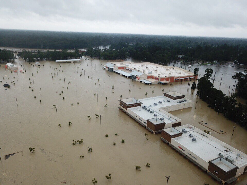
The @HEB Kingway Market along Lake Houston Pkwy.

Lake Houston Dam
Posted on 8/29/17 at 4:36 pm to TthomasJR
quote:
Slack,
How is your family holding up in Kelliwood?
They're pretty comfortable with the idea they won't flood and can safely get out to Westgreen without going through more than 6" of water, so they're staying put. It's going to be dicey 100yards east of them, but they should be fine. Thanks for asking.
Posted on 8/29/17 at 4:36 pm to Scoop
quote:
If the money is there to house takers 24/365 it should be there for the producers that have done the right thing and caught the worst of breaks.
I guess my question is this.
Everyone knows flood insurance is an option. In X zones... it's cheaper than the cost of cable TV.
I'm not sure you are "doing the right thing" if you don't buy flood insurance.
But it's just like how the Texas senators blasted aid for Sandy but you can bet they will have their hands out for this one.
We should help our fellow citizens in their time of need. Maybe now we will hear a lot less crap on the O-T about how people need to take care of themselves, etc.
Posted on 8/29/17 at 4:37 pm to Scoop
quote:There is no set way. Everyone's situation was different.
Probably walk away, declare bankruptcy, rent for several years while building up a big down payment on a new house in several years when out from under bankruptcy?
Do the people that have to walk away just take the credit hit or go the bankruptcy route?
The ones I know just took the credit hit. I have no idea where they went.
I'll add that people died later as a result of all of this. This lady I know, about 80 yr. old widow went into depression and died 3 months after her home had roof level water in it.
Posted on 8/29/17 at 4:37 pm to slackster
Any updated spaghetti models or path predictions since this morning?

 Page 569 of 618

Popular
Back to top