- My Forums
- Tiger Rant
- LSU Recruiting
- SEC Rant
- Saints Talk
- Pelicans Talk
- More Sports Board
- Coaching Changes
- Fantasy Sports
- Golf Board
- Soccer Board
- O-T Lounge
- Tech Board
- Home/Garden Board
- Outdoor Board
- Health/Fitness Board
- Movie/TV Board
- Book Board
- Music Board
- Political Talk
- Money Talk
- Fark Board
- Gaming Board
- Travel Board
- Food/Drink Board
- Ticket Exchange
- TD Help Board
Customize My Forums- View All Forums
- Show Left Links
- Topic Sort Options
- Trending Topics
- Recent Topics
- Active Topics
Started By
Message
re: Friday weather thread. Tornado watches everywhere, warnings, too
Posted on 3/31/23 at 12:27 pm to LegendInMyMind
Posted on 3/31/23 at 12:27 pm to LegendInMyMind
What’s different in the parameters between here and say Cleveland ms which is a TorCon of 7 close to the 9 area? Genuinely curious
 3
3

Posted on 3/31/23 at 12:29 pm to rds dc
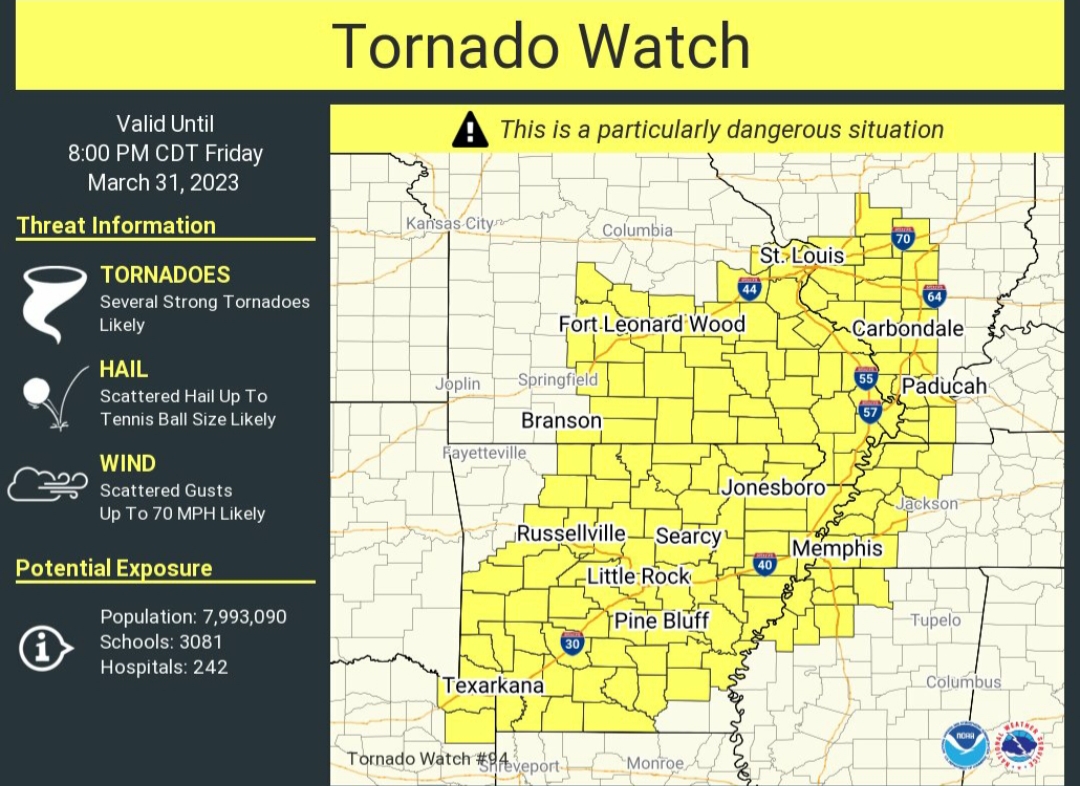
Second PDS watch of the day:
Posted on 3/31/23 at 12:31 pm to deltaland
quote:
What’s different in the parameters between here and say Cleveland ms which is a TorCon of 7 close to the 9 area? Genuinely curious
I have no idea what thresholds they use for TorCon. It is a proprietary product.
Posted on 3/31/23 at 12:31 pm to deltaland
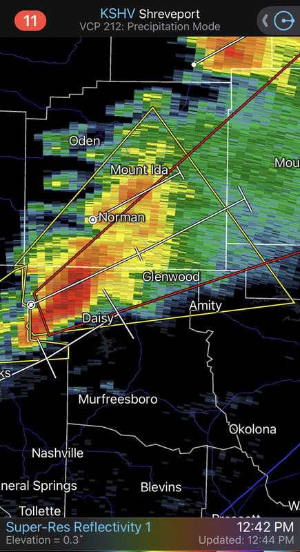
As I took this picture, I got the tornado watch notification. Wind is blowing about 20mph right now on top of this ridge.

Posted on 3/31/23 at 12:34 pm to WhuckFistle
got some pretty sizable cities in these PDS tornado watches
Posted on 3/31/23 at 12:35 pm to LegendInMyMind
A combined 13+ million population in the two PDS watch areas.
Not everyone will get hit but with that many people/towns there is a good chance someone will. I hope the bad ones stay in the open areas.
Not everyone will get hit but with that many people/towns there is a good chance someone will. I hope the bad ones stay in the open areas.
Posted on 3/31/23 at 12:36 pm to deltaland
quote:
TorCon
You’re better than this, delta…
Posted on 3/31/23 at 12:36 pm to rt3
quote:
got some pretty sizable cities in these PDS tornado watches
I’m in Amity, Arkansas. So for those smart enough and will better cell service/internet, let me know if I need to be on the look out.
Posted on 3/31/23 at 12:39 pm to WhuckFistle
It’s raining pretty good here all the way north to Memphis. Maybe that will cool things off and eliminate some of the instability
Posted on 3/31/23 at 12:41 pm to LegendInMyMind
What I think folks are trying to do in the 2 PDS zones...
Posted on 3/31/23 at 12:42 pm to East Coast Band
1st tornado warning of the day up in Iowa
Posted on 3/31/23 at 12:46 pm to East Coast Band
Posted on 3/31/23 at 12:49 pm to WhuckFistle
quote:
I’m in Amity, Arkansas. So for those smart enough and will better cell service/internet, let me know if I need to be on the look out.
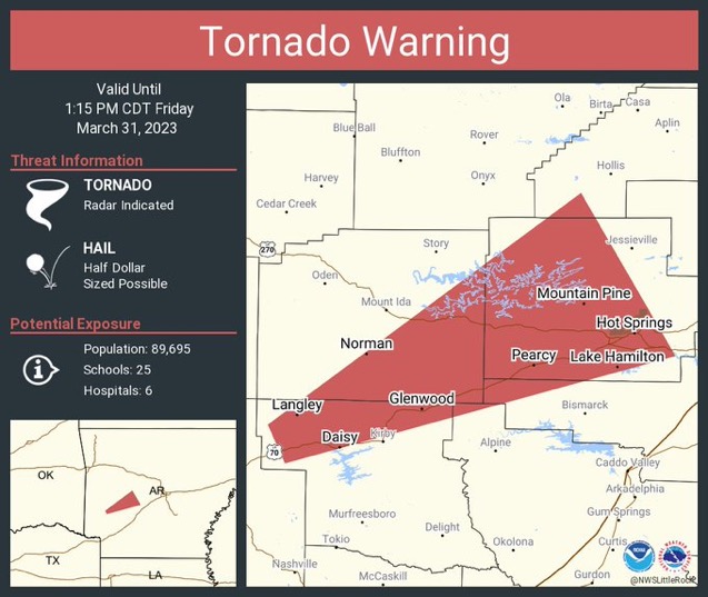
Heads up, tornado warning through 1:15pm for Clark, Montgomery, Garland, Perry, Pike and Hot
Spring counties.
This post was edited on 3/31/23 at 12:52 pm
Posted on 3/31/23 at 12:52 pm to WhuckFistle
quote:
I’m in Amity, Arkansas. So for those smart enough and will better cell service/internet, let me know if I need to be on the look out.

Posted on 3/31/23 at 12:52 pm to WhuckFistle
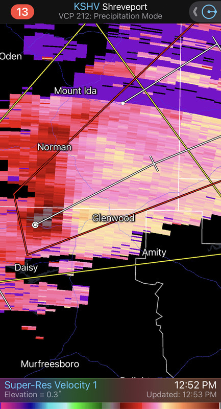
Heads up WhuckFistle...the polygon is just north of you but very close. Stay safe.
ETA - lachellie and Deltaland beat me to it.
quote:
A TORNADO WARNING REMAINS IN EFFECT UNTIL 115 PM CDT FOR SOUTHWESTERN PERRY...NORTH CENTRAL PIKE...WESTERN GARLAND... SOUTHEASTERN MONTGOMERY AND WEST CENTRAL HOT SPRING COUNTIES...
At 1249 PM CDT, a severe thunderstorm capable of producing a tornado was located near Norman, or 13 miles south of Mount Ida, moving northeast at 60 mph.
HAZARD...Tornado and two inch hail.
SOURCE...Radar indicated rotation.
IMPACT...Flying debris will be dangerous to those caught without shelter. Mobile homes will be damaged or destroyed. Damage to roofs, windows, and vehicles will occur. Tree damage is likely.
Locations impacted include... Hot Springs... Glenwood... Mountain Pine... Hot Springs Memorial Field... Meyers... Lake Ouachita State Park... Rockwell... Hot Springs National Park... Avant... Oaklawn Racetrack... Bonnerdale... Sunshine... Lodi... Royal... Lena Landing Rec Area... Fancyhill... Hamilton... Hempwallace... Salem in Pike County... Crystal Springs Landing...
PRECAUTIONARY/PREPAREDNESS ACTIONS...
TAKE COVER NOW! Move to a basement or an interior room on the lowest floor of a sturdy building. Avoid windows. If you are outdoors, in a mobile home, or in a vehicle, move to the closest substantial shelter and protect yourself from flying debris.
&&
TORNADO...RADAR INDICATED; MAX HAIL SIZE...2.00 IN
ETA - lachellie and Deltaland beat me to it.
This post was edited on 3/31/23 at 12:54 pm

Posted on 3/31/23 at 12:53 pm to lachellie
Welp, looks like it’s showtime.
Posted on 3/31/23 at 12:56 pm to NorthEndZone
Posted on 3/31/23 at 1:00 pm to lachellie
Thanks everyone. I’m probably in the clear, but all of my family is between here and glenwood, including my dads 94 yr old mother.
Hopefully nothing comes from this.
Hopefully nothing comes from this.
Posted on 3/31/23 at 1:01 pm to lachellie
Let us hear from you Whuck, when you can.
Posted on 3/31/23 at 1:03 pm to lachellie
Meso is on Glenwood right now

 Page 7 of 48

Back to top