- My Forums
- Tiger Rant
- LSU Recruiting
- SEC Rant
- Saints Talk
- Pelicans Talk
- More Sports Board
- Fantasy Sports
- Golf Board
- Soccer Board
- O-T Lounge
- Tech Board
- Home/Garden Board
- Outdoor Board
- Health/Fitness Board
- Movie/TV Board
- Book Board
- Music Board
- Political Talk
- Money Talk
- Fark Board
- Gaming Board
- Travel Board
- Food/Drink Board
- Ticket Exchange
- TD Help Board
Customize My Forums- View All Forums
- Show Left Links
- Topic Sort Options
- Trending Topics
- Recent Topics
- Active Topics
Started By
Message
re: Friday weather thread. Tornado watches everywhere, warnings, too
Posted on 3/31/23 at 11:02 am to LegendInMyMind
Posted on 3/31/23 at 11:02 am to LegendInMyMind
holy shite - i hope it is nowhere near as bad as they are thinking.
 0
0


Posted on 3/31/23 at 11:04 am to The Boat
Have a buddy thats an athletic trainer at University of Memphis. Just had ChatGPT write his obit for him.
Posted on 3/31/23 at 11:05 am to The Boat
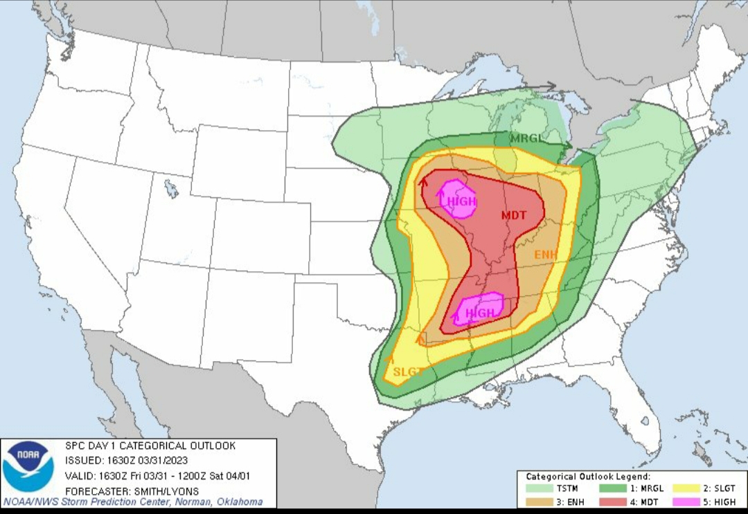
I hope this forecast doesn't verify. 30% is very rare for tornado probability.
This is getting concerning. Everyone in that area needs to be ready to get to a safe place to take shelter.
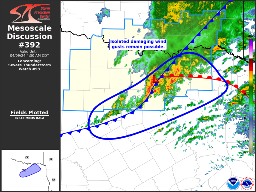
quote:
Mesoscale Discussion 0392
NWS Storm Prediction Center Norman OK
1047 AM CDT Fri Mar 31 2023
Areas affected...portions of eastern Arkansas...southwestern
Tennessee...and northern Mississippi
Concerning...Outlook upgrade
Valid 311547Z - 311645Z
SUMMARY...Portions of the Moderate Risk area over eastern AR,
southwestern TN, and northern MS will be upgraded to a categorical
High Risk in the 1630 UTC Convective outlook.
DISCUSSION...An upgrade to a tornado-driven High Risk (30%
probability) is expected for the 1630 UTC outlook. Environmental
conditions are quickly becoming favorable to support the potential
for numerous strong to potentially violent and long-track tornadoes
across portions of eastern AR, southwestern TN, and northern MS.
Please see the forthcoming Day 1 outlook update for more
information.
Posted on 3/31/23 at 11:05 am to The Boat
My county is touching the high risk on the north end and ENH on the south end
That’s not comforting that the high risk is only 30 miles north
That’s not comforting that the high risk is only 30 miles north
Posted on 3/31/23 at 11:06 am to deltaland
quote:
My county is touching the high risk on the north end and ENH on the south end
That’s not comforting that the high risk is only 30 miles north
That close is just splitting hairs.

Posted on 3/31/23 at 11:08 am to The Boat
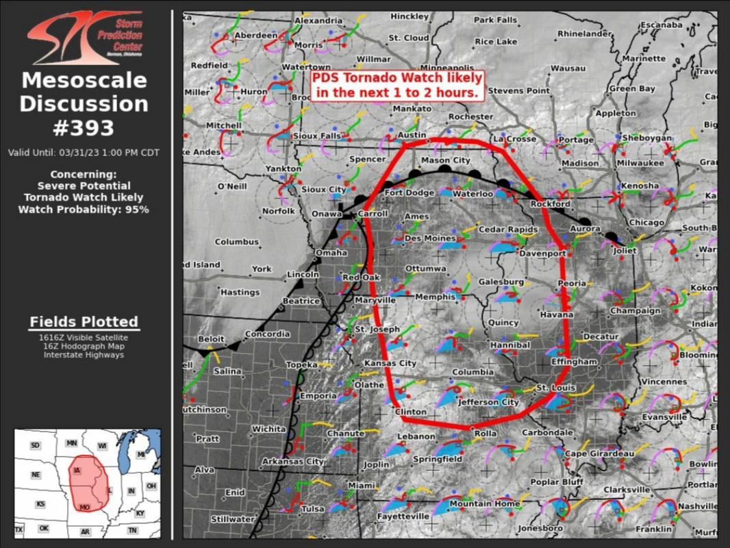
Wow two high risk areas for one event.
Posted on 3/31/23 at 11:11 am to The Boat
quote:
SPC upgrading to high risk at 16:30.
Do you still think it could creep further south in the southern area of concern or is the red area still pretty reflective of where you think this goes down?
Posted on 3/31/23 at 11:14 am to NorthEndZone
I’m not at all predicting this, but it’s been almost 10 years since the last EF-5 tornado in the United States. I wonder if today might be the day that changes. Things seem pretty ripe across a large area.
Posted on 3/31/23 at 11:19 am to The Boat
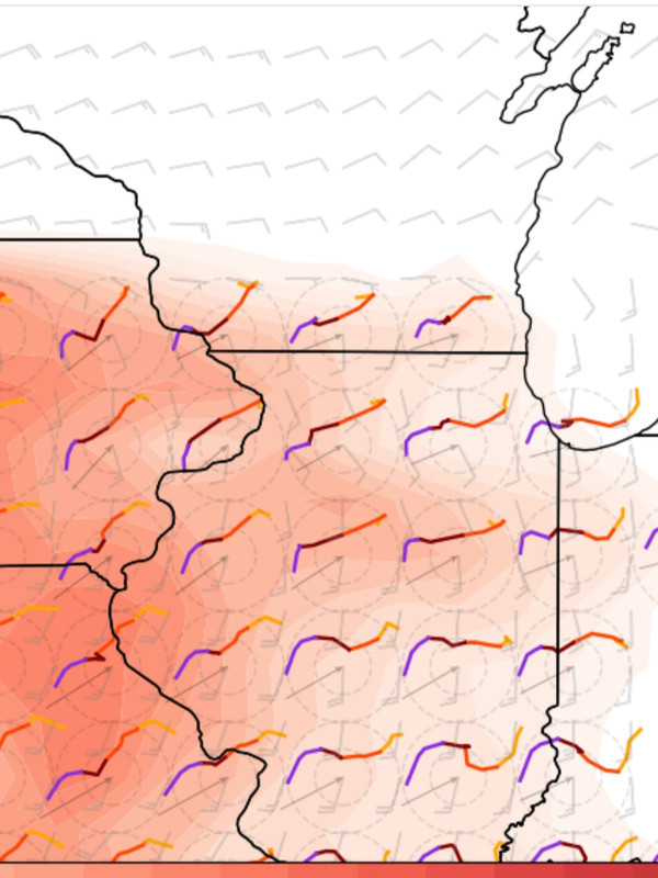
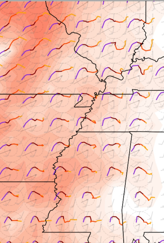
This is a huge area to see these type of hodographs.
Posted on 3/31/23 at 11:27 am to tide06
quote:
Do you still think it could creep further south in the southern area of concern or is the red area still pretty reflective of where you think this goes down?
Anywhere in the Enhanced area is of concern. Part of it will be upgraded to Moderate. On a day like today, those colors and boundaries don't mean much.
The southern extent will be dictated by timing and storm mode. I've pointed out the chance for Northern LA to have problems. Tail end storms on lines or line segments today are going to be problems. The general Shreveport area is in a sneaky bad spot.
This post was edited on 3/31/23 at 11:28 am
Posted on 3/31/23 at 11:31 am to LegendInMyMind
Legend, I’m approximately 45 miles ESE of NWS Shreveport office. I’m not asking you to pinpoint it but about how far south of Shreveport would you be concerned enough to consider bugging out further south for the day and maybe night?
Posted on 3/31/23 at 11:35 am to LegendInMyMind
Last question:
Do you see this setup as a “bad” day or is this now looking like a “historic” day?
Do you see this setup as a “bad” day or is this now looking like a “historic” day?
Posted on 3/31/23 at 11:36 am to lachellie
quote:
Legend, I’m approximately 45 miles ESE of NWS Shreveport office. I’m not asking you to pinpoint it but about how far south of Shreveport would you be concerned enough to consider bugging out further south for the day and maybe night?
I don't think it is necessarily a "bug out" scenario for you. It is more of a just be aware that you aren't in the clear. Unless you're in a bad living situation (mobile home and such) I would just take your normal storm precautions and keep an eye on things.
Posted on 3/31/23 at 11:37 am to LegendInMyMind
How about as far south as Cenla?
Posted on 3/31/23 at 11:38 am to Jim Rockford
quote:
How about as far south as Cenla?
The threat really drops off as you start to head south.
Posted on 3/31/23 at 11:39 am to LegendInMyMind
Thanks, I was in a house that was destroyed nearly 40 years ago and days like these give me PTSD flashbacks. I have a safety plan but I’m still a little shook at just watching the news from Mississippi last week.
Posted on 3/31/23 at 11:41 am to tide06
quote:
Do you see this setup as a “bad” day or is this now looking like a “historic” day?
It is hard to answer that with any setup. I think if things go right it could be really bad in Illinois.
It doesn't have to be historic on a large scale to be historic for any given person. If a tornado comes down your street, it will be historic no matter how the overall setup performs.
Posted on 3/31/23 at 11:41 am to LegendInMyMind
Unless I’m misreading this, this looks bad for me.

 Page 5 of 48

Popular
Back to top